Dan Robinson
EF5
When I awoke at 7am and started looking at morning data, it was clear that the tornado outbreak prospects had diminished considerably. All-night thunderstorms were still going, and they had pushed an outflow boundary south of the Ohio River. With the deeper moisture shunted so far to the south, it did not appear likely that it would be able to return north into the strongest areas of shear (the original threat area) in time. With the day's target seemingly much farther south and along I-64 to the east, I would not have as far to drive.
As I approached the Evansville area, some thunderstorms were still lifting northeast ahead of me. Unbeknownst to me, these were interacting with the outflow boundary to produce several tornadoes along I-64 in southern Indiana just after noon. I was about 30 minutes too late to see the closest one that crossed US 41 just south of I-64 at Warrenton:
My plan for the day was to stay with the western end of the outflow boundary as it lifted north. Satellite showed clear skies the southwest, and that developing instability would be pulled north into southern Indiana as the afternoon progressed. Furthermore, thunderstorms were beginning to develop in southern Illinois, and a tornado watch was issued.
I initially went north to Washington, expecting the storms to the southwest to begin encountering the outflow boundary somewhere around there. But the storms began turning more easterly, indicating that I needed to move east. Just like my June 25 chase last year, I would need to first make my way through the Hoosier National Forest before I would have clear views to observe the storms. East of Paoli, I found a spot with a view. To my west, several supercells were beginning to ramp up, each one with midlevel mesocyclones visible on radar. The strongest rotation was with a storm down near Evansville, and one heading right for me southwest of Paoli. The Paoli storm appeared to be having trouble maintaining its meso, and I felt it might need more time to organize. The storm speeds today were expected to be 60 mph or higher, which meant that one would need to stay well ahead of storms until it looked like it was ready to produce: once a storm got past you, there would be no way to get back ahead of it again.
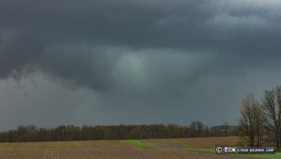
I moved over to Salem intending to keep my distance ahead of the Paoli storm, but the next storm to the west developed a much stronger low-level meso. It was also heading toward Paoli, so I backtracked a few miles to position ahead of it. This would mean letting the first storm go, which was still struggling to intensify. As it moved past me to the north, an RFD clear slot was evident, but motion was weak:
The second storm's meso to the west also was not taking off, so I started evaluating my options. The first storm was starting to look better, but it was already past me and out of reach. The original Evansville cell tracking along I-64 was maintaining a stronger meso, and looked like my best option. The fastest intercept route would be to go southeast to Georgetown, but the Sherman Minton Bridge was closed due to a major accident. The backup from that extended well west of the I-265 interchange, which meant going that way would leave me with no good options to stay ahead of the storm. So, I decided to head east to I-65 at Henryville and drop south.
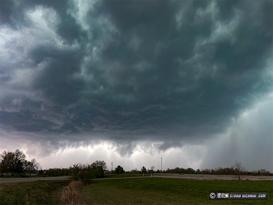
I just barely made it ahead of the I-64 storm, escaping the forward-flank precip at Sellersburg. I only had a minute to stop and look at the storm. By now, a very strong RFD surge was blasting east right along and south of I-265. This was the view of the storm just before it crossed I-65:
I turned east on I-265 to stay ahead. This highway was right in the storm's inflow notch. I stopped at International Drive, the last exit before the Lewis and Clark Bridge and tunnel (the tolled section of the highway). For the last 10 minutes, the storm had not had a very strong inflow corridor to counter the RFD push. But as it neared my location, that was evidently changing with a wall cloud taking shape and extending back into the rain.
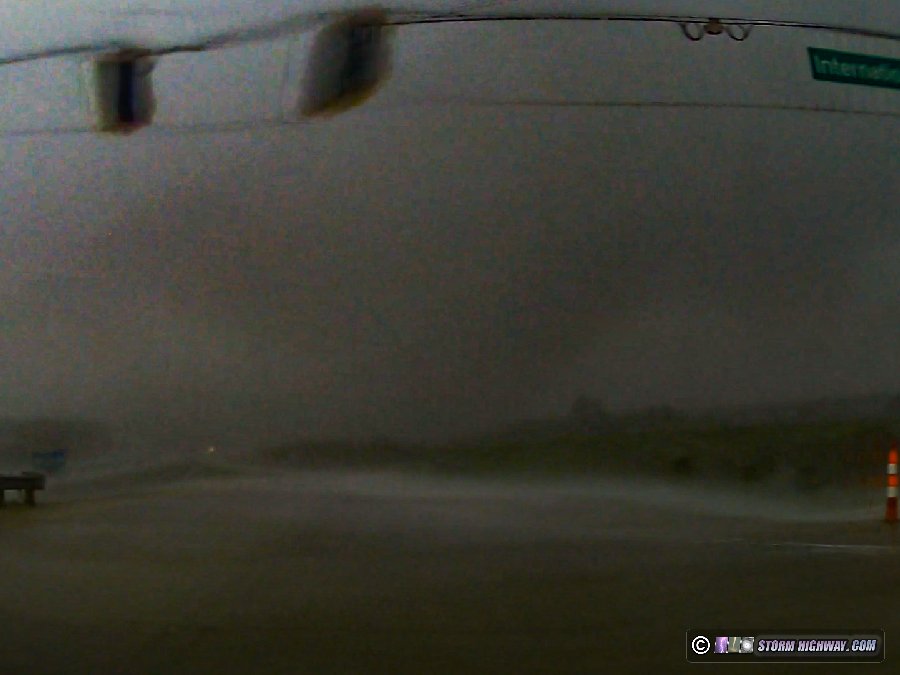
The storm was evolving rapidly at this point. Radar now showed a strong couplet developing at this location as the RFD gust front arrived, both ominous signs. The circulation was rain-wrapped and appeared to be heading in my general direction, so it was obvious I needed to move south out of its way. Southerly winds started ramping up as I cleared the intersection, and unbeknownst to me at the time, the rain had cleared somewhat to reveal a tornado visible over the highway to my west. My passenger-side dashcam captured it.
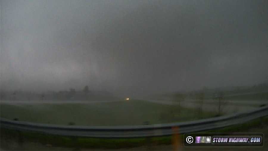
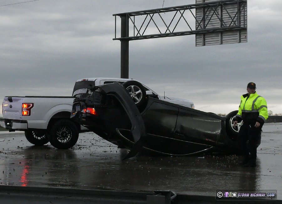
About a quarter-mile south of the interchange, the southerly wind ramped up rapidly, shifted to the west and intensified even more. A sign and a tree can be seen toppling in my video (see the video linked on this page). This was my first indication that a tornado was likely in progress to my north. I moved south quickly to keep a better margin of distance away from it, then immediately returned to the intersection to see if there was any definitive evidence of a tornado. I arrived to find fresh tornado damage at the interchange, with vehicles flipped. I immediately reported this to NWS Louisville within a minute of the tornado's impact. EMS arrived on the scene after only a couple of minutes.
A tractor-trailer that had turned east onto the on-ramp had been picked up by the tornado and flipped over the concrete barrier, coming to rest on the adjacent Lewis and Clark Bridge Trail. This took a big chunk out of the barrier:
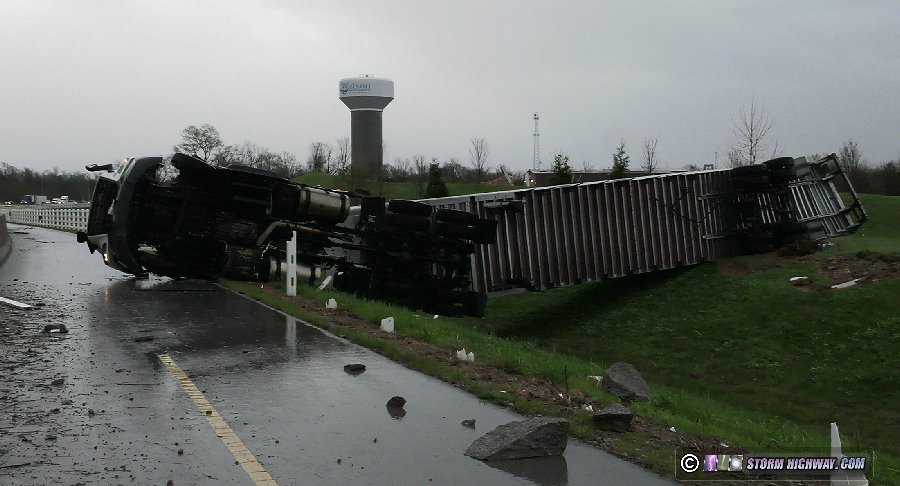
There were at least four semis that had been overturned at this location.
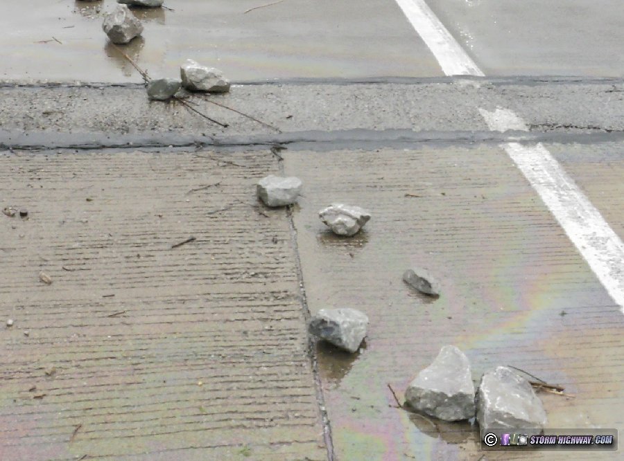
The most significant indication of stronger ground-level winds that I saw here was 8 to 10-inch riprap rocks blown onto the road.
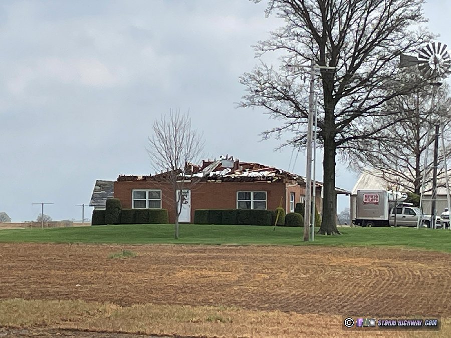
Despite this, overall damage at this location was not indicative of a violent or even a very strong tornado. In the first image of the car above, you can see a large-surface-area overhead highway sign that was not toppled. All of the light and traffic light poles were also still standing. It appeared that the damage wasn't any higher than EF-1.
Video:
As I approached the Evansville area, some thunderstorms were still lifting northeast ahead of me. Unbeknownst to me, these were interacting with the outflow boundary to produce several tornadoes along I-64 in southern Indiana just after noon. I was about 30 minutes too late to see the closest one that crossed US 41 just south of I-64 at Warrenton:
My plan for the day was to stay with the western end of the outflow boundary as it lifted north. Satellite showed clear skies the southwest, and that developing instability would be pulled north into southern Indiana as the afternoon progressed. Furthermore, thunderstorms were beginning to develop in southern Illinois, and a tornado watch was issued.
I initially went north to Washington, expecting the storms to the southwest to begin encountering the outflow boundary somewhere around there. But the storms began turning more easterly, indicating that I needed to move east. Just like my June 25 chase last year, I would need to first make my way through the Hoosier National Forest before I would have clear views to observe the storms. East of Paoli, I found a spot with a view. To my west, several supercells were beginning to ramp up, each one with midlevel mesocyclones visible on radar. The strongest rotation was with a storm down near Evansville, and one heading right for me southwest of Paoli. The Paoli storm appeared to be having trouble maintaining its meso, and I felt it might need more time to organize. The storm speeds today were expected to be 60 mph or higher, which meant that one would need to stay well ahead of storms until it looked like it was ready to produce: once a storm got past you, there would be no way to get back ahead of it again.
I moved over to Salem intending to keep my distance ahead of the Paoli storm, but the next storm to the west developed a much stronger low-level meso. It was also heading toward Paoli, so I backtracked a few miles to position ahead of it. This would mean letting the first storm go, which was still struggling to intensify. As it moved past me to the north, an RFD clear slot was evident, but motion was weak:
The second storm's meso to the west also was not taking off, so I started evaluating my options. The first storm was starting to look better, but it was already past me and out of reach. The original Evansville cell tracking along I-64 was maintaining a stronger meso, and looked like my best option. The fastest intercept route would be to go southeast to Georgetown, but the Sherman Minton Bridge was closed due to a major accident. The backup from that extended well west of the I-265 interchange, which meant going that way would leave me with no good options to stay ahead of the storm. So, I decided to head east to I-65 at Henryville and drop south.
I just barely made it ahead of the I-64 storm, escaping the forward-flank precip at Sellersburg. I only had a minute to stop and look at the storm. By now, a very strong RFD surge was blasting east right along and south of I-265. This was the view of the storm just before it crossed I-65:
I turned east on I-265 to stay ahead. This highway was right in the storm's inflow notch. I stopped at International Drive, the last exit before the Lewis and Clark Bridge and tunnel (the tolled section of the highway). For the last 10 minutes, the storm had not had a very strong inflow corridor to counter the RFD push. But as it neared my location, that was evidently changing with a wall cloud taking shape and extending back into the rain.
The storm was evolving rapidly at this point. Radar now showed a strong couplet developing at this location as the RFD gust front arrived, both ominous signs. The circulation was rain-wrapped and appeared to be heading in my general direction, so it was obvious I needed to move south out of its way. Southerly winds started ramping up as I cleared the intersection, and unbeknownst to me at the time, the rain had cleared somewhat to reveal a tornado visible over the highway to my west. My passenger-side dashcam captured it.
About a quarter-mile south of the interchange, the southerly wind ramped up rapidly, shifted to the west and intensified even more. A sign and a tree can be seen toppling in my video (see the video linked on this page). This was my first indication that a tornado was likely in progress to my north. I moved south quickly to keep a better margin of distance away from it, then immediately returned to the intersection to see if there was any definitive evidence of a tornado. I arrived to find fresh tornado damage at the interchange, with vehicles flipped. I immediately reported this to NWS Louisville within a minute of the tornado's impact. EMS arrived on the scene after only a couple of minutes.
A tractor-trailer that had turned east onto the on-ramp had been picked up by the tornado and flipped over the concrete barrier, coming to rest on the adjacent Lewis and Clark Bridge Trail. This took a big chunk out of the barrier:
There were at least four semis that had been overturned at this location.
The most significant indication of stronger ground-level winds that I saw here was 8 to 10-inch riprap rocks blown onto the road.
Despite this, overall damage at this location was not indicative of a violent or even a very strong tornado. In the first image of the car above, you can see a large-surface-area overhead highway sign that was not toppled. All of the light and traffic light poles were also still standing. It appeared that the damage wasn't any higher than EF-1.
Video:
Last edited: