• After witnessing the continued decrease of involvement in the SpotterNetwork staff in serving SN members with troubleshooting issues recently, I have unilaterally decided to terminate the relationship between SpotterNetwork's support and Stormtrack. I have witnessed multiple users unable to receive support weeks after initiating help threads on the forum. I find this lack of response from SpotterNetwork officials disappointing and a failure to hold up their end of the agreement that was made years ago, before I took over management of this site. In my opinion, having Stormtrack users sit and wait for so long to receive help on SpotterNetwork issues on the Stormtrack forums reflects poorly not only on SpotterNetwork, but on Stormtrack and (by association) me as well. Since the issue has not been satisfactorily addressed, I no longer wish for the Stormtrack forum to be associated with SpotterNetwork.

    I apologize to those who continue to have issues with the service and continue to see their issues left unaddressed. Please understand that the connection between ST and SN was put in place long before I had any say over it. But now that I am the "captain of this ship," it is within my right (nay, duty) to make adjustments as I see necessary. Ending this relationship is such an adjustment.

    For those who continue to need help, I recommend navigating a web browswer to SpotterNetwork's About page, and seeking the individuals listed on that page for all further inquiries about SpotterNetwork.

    From this moment forward, the SpotterNetwork sub-forum has been hidden/deleted and there will be no assurance that any SpotterNetwork issues brought up in any of Stormtrack's other sub-forums will be addressed. Do not rely on Stormtrack for help with SpotterNetwork issues.

    Sincerely, Jeff D.

Very dry air aloft

Jeff Duda

site owner, PhD
Staff member
Site owner
Supporter
Joined
Oct 7, 2008
Messages
3,822
Location
Thornton, CO
I'm only starting this thread because I've never seen water vapor imagery like this nor the associated dryness:

US_WV_082210_1915.jpg


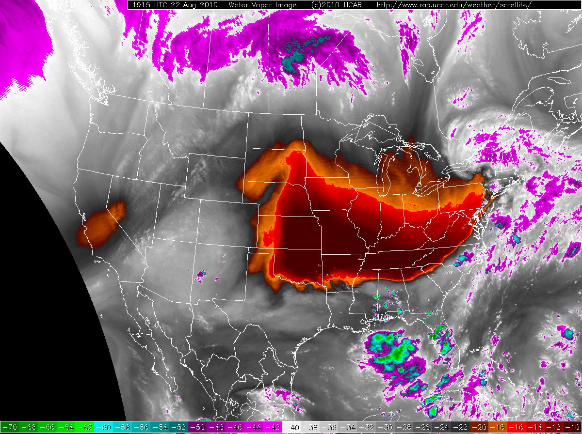
That's very dry air in place over the central US. The Springfield, MO (SGF) sounding from 12Z this morning is equally impressive, with dewpoint depressions in the 500 - 400 mb layer > 40 C throughout and maxing out at 48.0C! That's a relative humidity of around 1%! Despite surface dewpoints around 70 F in E KS and W MO, current RUC analyzed PWs are < 1", which attests to the incredible dryness of the air. Cool stuff.
 
Interesting information Jeff. Let me pose a question: Did any of the current model data (NAM/WRF or even GFS) for the 00z or 12z time frame depict this? Keep in mind that I have not looked at any output at all today. Just kind of curious as to how well the model output did/was?
 
Yeah. I like the detailed output of the SPC soundings.

Lanny, I too was curious about that and took a look.

Here is the TwisterData forecast sounding from the 0z GFS run today.

http://www.twisterdata.com/index.ph...iew=large&archive=false&sounding=y&sndclick=y

Seems like the GFS underestimated the depth of the dry air and dryness of the dry layer but almost nailed the winds. (Try to say that sentence five times fast.) Looks like the NAM also had the same problems.
 
Thanks Greg! I was actually just looking over data and was about to make another post with the graphic from the NAM when I saw your post. Thanks for looking for me ;) lol
 
Jeff, for those of us who are noobs, where did you get that image?

Hi, Jim.

The URL for the image can be found in the image across the top.

I have a script that takes these images and puts them into an interface that allows for java script looping. You can find them here: http://weather.forwarn.org

(Note, even though the page says the satellite feed is dead, it isn't!)
 
Back
Top