Since I’ll be on ice May 15th-19th I’m looking a little further ahead than most and am quietly becoming optimistic. Others have pointed out the pattern shift with SW flow starting around the 13th. I just want to add that every model I see has that pattern sticking around for a while. The CFS has the pattern holding until the 28th. Of course the CFS is the only one going out that far, but I’ll be doing cartwheels if the other models come into agreement over the coming week.
-
While Stormtrack has discontinued its hosting of SpotterNetwork support on the forums, keep in mind that support for SpotterNetwork issues is available by emailing [email protected].
You are using an out of date browser. It may not display this or other websites correctly.
You should upgrade or use an alternative browser.
You should upgrade or use an alternative browser.
State of the Chase Season 2025
- Thread starter Dan Robinson
- Start date
Warren Faidley
Supporter
Moisture return can occur rather quickly this time of year, and with the saturated soil out west, the models may be underestimating the DP's. It's also not uncommon for RH to sneak up through the Pecos Valley this time of year. I'm departing on the 11th.
Bobby Little
Supporter
realistically those 3 days might be the only decent ones in your period i'd hate to sayI’ve already written off Fri-Mon as being hopeless for good chase days. Marginal upslope activity does appear likely for 1 or 2 of those days despite low DPs, so there’s that at least. Tuesday is the first glimmer of hope as the ULL exits and flow and moisture begin to return…problem is, the models show fairly stong capping with the first couple days of good moisture return. Who knows if that holds at this range though.
I’m close to pulling the trigger and extending my trip 3 more days (end date 5/18 instead of 5/15). Probably going to make that decision around Thurs-Fri this week.
Warren Faidley
Supporter
Just remember we are entering the time of year when obvious set-up dates often produce even better results on the "pre-day(s). I've been burned more times than I can count when I tried to cut it too close.
JamesCaruso
Staff member
Just remember we are entering the time of year when obvious set-up dates often produce even better results on the "pre-day(s). I've been burned more times than I can count when I tried to cut it too close.
Great reminder Warren. I’m trying to resist the temptation to cut it too close myself. Not necessarily even thinking of a “day before the day” situation. More so just for going out in general. If I wait too long into this first 8 day period I have beginning on the 13th before going out there, it will seem less and less worthwhile once the remaining available window has shortened. Or I’ll be questioning whether the setup is worth a last-minute scramble to rearrange my schedule and get out there in time (if the last minute logistics are even still workable). Might as well just plan to head out for the 13th no matter what; then once I am there, I can make less-biased decisions about what’s worth chasing. At worst I’ll waste a little money and travel time. But even worst case with no good chasing, some time to myself and a change of scenery won’t be the worst thing in the world.
They do look very nice. However I’m liking the good trend continuing in the 12z models to make Wednesday and Thursday next week decent severe days. Pair that with one or two low end days with high based junk and lightning and I’m happy enough. So even if I don’t extend my trip my original dates don’t look completely dead yet.realistically those 3 days might be the only decent ones in your period i'd hate to say
Brett Roberts
EF5
Well, the ensembles have definitely shifted more toward SW flow over the past couple days... to the point that SW flow appears quite plausible over the S/C Plains by mid-late next week (5/13-5/16). The 12z EPS even has 30-40 kt flow in the ensemble mean for several days, almost reminiscent of an upper air pattern like late May 2016... with one catch. I'm actually worried about blowing this momentum too early, before we can really shake the SE troughing and reestablish quality moisture.
Regardless, it seems likely that reasonable chase opportunities somewhere in the core alley will emerge by mid-month, which is an improvement from the prognosis several days ago.
Regardless, it seems likely that reasonable chase opportunities somewhere in the core alley will emerge by mid-month, which is an improvement from the prognosis several days ago.
Bobby Little
Supporter
Just got back from Derby and wanted to chase after. That omega cutoff low ruined most the weekend and my chase plans.
To make things worse "this low continues to follow me wherever i go..." jus saying
To make things worse "this low continues to follow me wherever i go..." jus saying
Brett Nickeson
EF2
Euro and GFS in fairly good agreement now with regards to southwest flow and a trough returning on 5/14. Moisture return looks fairly poor and displaced that day but subsequent southwest flow over the next several days will have much better moisture. Things are looking like they might start kicking off around the 5/16 time period.
Hope I didn't just jinx it.
Hope I didn't just jinx it.
I personally am looking forward to this omega-block ..
because while nothing severe, looks like the western low will setup in the right location to provide some good rain where I am over the next couple days.
Looking at various models I was seeing 1-1.5" with most, but up to 2" on the higher end. (total through wed evening)
With as dry as its been, any bit of rain is good, and especially an amount like that!
Plus along with that rain there is some chance for a bit of lightning (yeah minor chance, but I love lightning-shows, so I can hope for that as an added bonus to the rain.)
Oh and in the mountains there could be a couple feet of snow, so that would be a late-season boost to the below-normal snowpack.
JamesCaruso
Staff member
Seems like the middle of next week will come down to two things:
1. How fast can that ULL get out of the southeast?
2. Will the trough in the west dig and slow down enough to allow for decent moisture return?
If the timing is right we may get chaseable weather back as early as Tues-Wed. If not we have to wait for Thurs-Fri.
1. How fast can that ULL get out of the southeast?
2. Will the trough in the west dig and slow down enough to allow for decent moisture return?
If the timing is right we may get chaseable weather back as early as Tues-Wed. If not we have to wait for Thurs-Fri.
John Farley
Supporter
Due to early week commitments, I am hoping for the Thursday-Friday timing. That said, if you were in the right place and are interested in wild weather phenomena besides tornadoes, the stalled upper low pattern the past week has offered some interesting stuff, at least in New Mexico. Without ever getting more than 20 miles from Santa Fe I observed thundersnow on multiple days, SVR-warned storms, snow and hail at the same time, and a lot of other interesting weather. Probably nothing worth crossing half the country to chase, but interesting and in some ways quite unusual if you were in the right place to begin with , like I was. Elsewhere in NM, there were even a daytime landspout tornado one day near Roswell, a funnel on a tornado-warned storm on an otherwise busted NM-TX tornado watch another, and severe storms with large hail, including supercells in a variety of places and over several days. I made a post on my observations on another thread so won't post any specifics here, but the point is that there is often interesting weather somewhere even if the overall pattern is what many of us consider boring.
Jason N
EF5
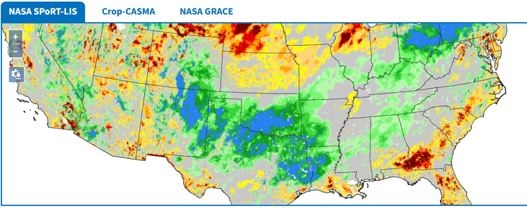
Again, I'll go back to the trends, and they continue to improve, the mesoscale will have to work itself out, but as James showed, the ground recently has been given some good moisture to perhaps in the short term keep the soil moisture content a little higher. That, and the fact that the period around the 13 to16 time frame looks fairly optimal from the mid-level perspective that I think will adjust as you get lower down to the surface over time. I'm of the opinion that the odds are pretty good of there being some quality days ahead.. and the longer term gives the impression that the 5 wave isn't going to be controlled by a dominating unmoving ridge, but that waves will still be moving across CONUS, despite there being periods of lesser or more activity. So, I am continuing with my modest confidence line of thinking.
Jason N
EF5
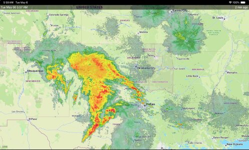
Glad to see lots of beneficial rain this morning - another variable shifting in our favor for later?
View attachment 27331
Similar threads
- Replies
- 61
- Views
- 7K
- Replies
- 12
- Views
- 2K

