William Monfredo
EF4
"You don't always get what you go after, but you do get what you wouldn't have got if you hadn't gone after what you didn't get." - Blaze Foley.Well I’m finally pulling the trigger.
"You don't always get what you go after, but you do get what you wouldn't have got if you hadn't gone after what you didn't get." - Blaze Foley.Well I’m finally pulling the trigger.
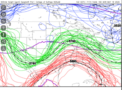
I think that's a solid point and one that doesn't get a lot of play about upstream data influencing and effecting model output. A good friend of mine used to fly on Ms. Piggy when they were doing Pacific runs during the winter months, and I remember how the extra releases of soundings would be of some additional benefit over geographically data sparse regions leading to down range model benefits. it will be a good thing when radio-occultation data starts filling in those gaps I think, and maybe some of these wide swings in synoptic / long range guidance might smooth outoombined with reduced radiosonde launches over the northern Plains and Rockies,
 It looks like I’ll miss some good days, but all hope isn’t lost. Starting later next week there will be some opportunities for some fun chases. The CAPE values will be lower, which I can deal with and the storms that can fire will be closer to the slower moving variety that I really love. I’ll take what I can get and be happy about it.
Todd, cant you hit that graduation a day early? SPC showing enhanced through woods of WisconsinThe state of my chase season is that I’ll be heading to Green Bay Friday the 16th for another of our kids graduations until the following Tuesday. I now realize that if you have four kids spaced out just right you can have a graduation every May for eight years straight.