That’s a great thought. The problem is my wife and two of are daughters (including the one graduating) are flying with me and we didn’t get insurance on the flights. I will check on this though and repost. A helpful note to anybody chasing this and is unfamiliar with the chasing in Wisconsin. You can basically draw a line straight West from Green Bay and if a storm heads North of that line you should just say goodbye. There just aren’t many places you can see anything North of that.Todd, cant you hit that graduation a day early? SPC showing enhanced through woods of Wisconsin
-
While Stormtrack has discontinued its hosting of SpotterNetwork support on the forums, keep in mind that support for SpotterNetwork issues is available by emailing [email protected].
You are using an out of date browser. It may not display this or other websites correctly.
You should upgrade or use an alternative browser.
You should upgrade or use an alternative browser.
State of the Chase Season 2025
- Thread starter Dan Robinson
- Start date
Not sure anyone cares, but I can change my flight to Thursday morning. I asked my brother who lives there to pick me up at the airport and chase from there. He said he wants to look at the models in the morning to decide. He’s worried about missing trap shooting….. For the record, this is the same brother that caused me to miss Chapman in 2016 because he had to get home to “water his grass”. Hopefully the models looks awesome in the morning. We’re already knee deep into the season and I’ve barely been out due to circumstances beyond my control.
Friday through Tuesday all look like chase days, with Sunday, Monday and Tuesday likely being the peak. Hopefully we can keep some at least zonal flow meso days going beyond that, but globals are still unreliable at that range. At the very least the first week of chase vacation looks like really good potential!
Jason N
EF5
Might as well start putting up Target Area Chats for the 18th, 19th, and 20th across OK/TX, lol
Warren Faidley
Supporter
Two solid, Central Plains chase days could be realized on Sunday (18th) and Monday (19th). Still a lot TBD, especially with storm modes and DL placement. Hopefully, there will be multiple target zones to thin out the onslaught of chasers and Klingons. This set-up (current forecast), gives me the heebie-jeebies -- it's got that ICT OKC danger feeling.
Models are somewhat synced and reasonable with shifting RH east for a few days after this next system passes. Models diverge in regards to the UL flow afterwards, with ridging to zonal to NW -- not going to worry about that this far out.
Models are somewhat synced and reasonable with shifting RH east for a few days after this next system passes. Models diverge in regards to the UL flow afterwards, with ridging to zonal to NW -- not going to worry about that this far out.
Jason N
EF5
I was already wondering about the possibility of SPC bumping up to 30% for the 19th... there are a few things that will surely be answered when the models get a little closer in, but the timing/location of the mid-level jet max and corresponding shrtwv, juxtaposed to some of the Sub LLJ features and capping on the Skew-T I think will work themselves out, and of course how the SFC environment looks each day from left over boundary's and where the best backed wind fields will be at the time. but the Synoptic setup looks pretty good for this period.Two solid, Central Plains chase days could be realized on Sunday (18th) and Monday (19th). Still a lot TBD, especially with storm modes and DL placement. Hopefully, there will be multiple target zones to thin out the onslaught of chasers and Klingons. This set-up (current forecast), gives me the heebie-jeebies -- it's got that ICT OKC danger feeling.
Models are somewhat synced and reasonable with shifting RH east for a few days after this next system passes. Models diverge in regards to the UL flow afterwards, with ridging to zonal to NW -- not going to worry about that this far out.
Jason N
EF5
Oh man, the Chaser Convergence Hoard will be almost too much to bear in some places if the convective coverage is limited.
Bobby Little
Supporter
This is my main concern for the weekend. Pent-up demand explodes with population of Rhode Island chasing in the plains sun-tues. my plan was to target the alt. south target mid ill./in. for thurs. drop down to my target area of south tip of ill. for Friday. Get to OkC for Sunday. Kansas for Monday. Chash east Tuesday on my way home. gotta decide if the plains chase will be worth the traffic/chaos i expect??Oh man, the Chaser Convergence Hoard will be almost too much to bear in some places if the convective coverage is limited.
Hopefully there is enough coverage to provide a secondary option at least. Every Tom, Dick, and Harry will be out there chasing the most prime target spot, so having that in the back pocket would make for a more enjoyable chase experience than fighting NYC traffic on a dirt road in western KansasOh man, the Chaser Convergence Hoard will be almost too much to bear in some places if the convective coverage is limited.
Sean Ramsey
EF5
Oh man, the Chaser Convergence Hoard will be almost too much to bear in some places if the convective coverage is limited.
At least I know the TV media guys will be in the conga line with the rest of us.
Mikaela Norris
EF2
As much as I like Colorado Springs, I seriously miss living in Oklahoma right about now. A trip down there this weekend just isn't feasible for me at the moment unfortunately. Maybe if things setup a little farther west than currently forecast Sunday I could make a run into SW Kansas or the Panhandles, but right now it seems like I'll be missing out. It's just a long way to go when I also have to be at work bright and early Monday. Hopefully we'll get some good Colorado opportunities in June.
Eric Bucsela
EF2
On the 12z ECMWF, GFS and NAM, Saturday has potential to be a “day-before-the-big-day” kinda day. No idea about capping, but shear and moisture look to be there. And climatology of course.
Warren Faidley
Supporter
Three things strike me about the latest run of the GFS (5-14 @18z). 1: Saturday is likely to be in play (and could be a very good day), 2: the CAP does not seem to be a big problem (especially further north) and 3: the tornado juice is still hugging the OK / Texas panhandles / W. Central KS -- allowing for better chase terrain through cell maturity, especially during the early stages when visibility will be best. The big question to be determined is whether to play the south option for three days or go further north and avoid storms moving into the OKC clown zone. My final decision will likely be based on storm day hodos and trying to avoid HP cells. Since Saturday could provide some OFB's, it makes things even more interesting on multiple levels.
Jason N
EF5
slightly off topic thought, but got me wondering,.. what do you think the consensus would be on doing something like a MS Teams page to discuss these topics, or maybe Target Weather, since you can post images, files, and still chat.. I really didn't know where else to put this, except to write a thread... meh, or on the chat window, but it doesn't seem to get a lot of looks lol.. the board here is great, don't get me wrong.. but I was thinking alternatives to this that might be more "live" .. where that format might be useful. I don't have a discord, so that might be everyone's first answer, lol..
the interesting thing about teams at least would that there could be something like a METCON on days 1 and 2 for chaser chat.. analysis, or interesting points ... another reason it might be a useful platform.
the interesting thing about teams at least would that there could be something like a METCON on days 1 and 2 for chaser chat.. analysis, or interesting points ... another reason it might be a useful platform.
Jason N
EF5
Well, the first Hack NAM has on Sunday Night (18th) looks like this. (Guaranteed to change), so not really worth getting TOO excited about but, watching these trends will be important over the next 30hrs, not to mention with the shotgun repetition and left over boundaries will be certainly things to watch for. However, the synoptic conditions as well as some of the parametric have continued to show potentially good outcomes.
The other nice thing seems to be that there could be a few areas so chaser convergence may not be AS extreme. One interesting point of note in the NAM is the Nocturnal early AM TS IVO the Red River that advects northward during the day Sunday, and the precedent Convective/frontal thermal bndry across Nrn ArKSas into SE KS.. could be some interesting focal points and localized benefits or detractors during the reset hours.
Below, I chose
West of ICT
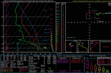
West of OKC
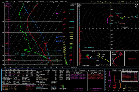
and
IVO Tulsa
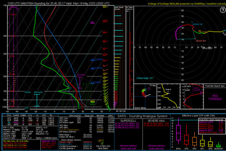
The other nice thing seems to be that there could be a few areas so chaser convergence may not be AS extreme. One interesting point of note in the NAM is the Nocturnal early AM TS IVO the Red River that advects northward during the day Sunday, and the precedent Convective/frontal thermal bndry across Nrn ArKSas into SE KS.. could be some interesting focal points and localized benefits or detractors during the reset hours.
Below, I chose
West of ICT

West of OKC

and
IVO Tulsa

Last edited:
Similar threads
- Replies
- 61
- Views
- 7K
- Replies
- 12
- Views
- 2K
