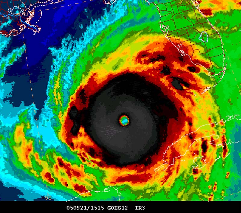
NOW: Hurricane Rita

Oy, again. The 00Z GFS coming in spoofs R making landfall somewhere near Lake Charles, LA, then turns it west just off the coast and inland somewhere up the coast from Houston, then stalls it on the TX-LA border, then loops the remnant off the coast and back through Houston next Tuesday morning. Blub, blub, blub.

There are a lot of people going to reeeeelly hate Rita in the next few days, I fear, including every tropical meteorologist in the Western Hemisphere plus a large fraction of the offshore oil and gas industry.

I'm not convinced with this novel solution, but hit Houston, stall, and bumble around is looking more likely, though. :roll:
 
I notice in the latest model runs that many of the models show Rita landfalling and then turning west or southwest into central Tx. What do you folks think of this trend? Do you think it is really possible?
 
Just a note regarding the "Early-cycle" plots on http://euler.atmos.colostate.edu/~vigh/gui...dance/index.htm

The forecast aids fit into two categories: early-cycle products and late-cycle products. Early-cycle products are forecast aids which only take a short time to produce and are available at the synoptic time. Most of the statistical and simple dynamical models fit into this category. Late-cycle products are the forecast aids which take longer to run and hence, are not available at the synoptic time. These are generally available 6-h after the synoptic time, so by the time you get them, the forecast is already 6-h old. The global and regional models, and the products which depend on them are generally late-cycle products. To allow comparison between the early- and late-cycle products, the late-cycle products are interpolated in time to the same times as the early-cycle products. Thus, in the early-cycle plots, all the forecast aids with a 'TECH' identifier ending in 'I' are interpolated late-cycle products and represent a forecast at least 6-h old.

The 0z GFS is indeed quite a change. That would put the southern LA coast in the surge zone, and I've heard that that part of LA is largely swamp-land-like, making chasing a little more difficult. In addition, this would largely "save" Houston and Galveston given that those areas would be in offshore flow. This probably really should go into the FCST thread and not the NOW thread, so I'll stop here.
 
It is as scary as it is beautiful....
If hell had a name it would be Rita.

theperfectstormsept211130ameasternrita.jpg
 
http://tropicalupdates.nhcwx.com/recon.htm

is a good sight for recon info... the page will refresh every 10 minutes or so.

on the first pass through the NE eyewall they picked up a max flight level wind of 165 knots which is a little less than 150 on the ground.

EDIT: It looks like the heights rose about 20 meters and temperature and d-values are about the same... they should return about the same pressure.

officially 898 mb...
 
Originally posted by 6z VORTEX

MAX FL WIND 165 KT NE QUAD 05:34:00 Z
FREQUENT LIGHTNING
MODERATE TURBULENCE IN EYEWALL
EXTREMELY IMPRESSIVE STADIUM EFFECT IN MOONLIGHT

Very interesting... I wish they could take some pictures of that eyewall at night... Somehow, I'd think they'd need a lens with F/1 and ISO16000 on a standard dSLR to capture much given the fast motion of the place + very little light (only moonlight).
 
Originally posted by Jeff Snyder
Very interesting... I wish they could take some pictures of that eyewall at night... Somehow, I'd think they'd need a lens with F/1 and ISO16000 on a standard dSLR to capture much given the fast motion of the place + very little light (only moonlight).
My words exactly...this would be really interesting to see. I love pictures of eyewall...but with moonlight...oh my.. can't even imagine that beauty! 8)
 
Now officially 897mb. I can't see it going much lower than that -- there was a double wind maxima on the outbound flight through the NW quad, so I'm guessing the ERC will begin sometime today.
 
Max winds 134kts flightlevel in SW quad of storm, max winds 159kts flightlevel in NE quad of the storm. Down a bit from the 165kt in the last pass.


0905. 2448N 08803W 03061 5445 306 128 122 122 133 02663 0000000000
0906 2449N 08802W 03067 5531 304 132 104 104 134 02583 0000000100
0906. 2451N 08801W 03061 5615 307 114 128 128 127 02493 0000000100
0907 2452N 08759W 03060 5682 306 081 154 154 091 02424 0000000000
0907. 2453N 08758W 03061 5726 309 054 184 144 066 02381 0000000000
0908 2455N 08757W 03057 5750 324 030 228 128 036 02353 0000000000
0908. 2456N 08756W 03062 5766 360 016 248 114 020 02342 0000000000
0909 2456N 08754W 03060 5778 082 005 250 110 009 02329 0000000000

...


0915. 2505N 08751W 03057 5666 125 116 156 156 120 02438 0000000000
0916 2506N 08750W 03072 5601 131 136 114 114 141 02517 0000000100
0916. 2507N 08749W 03065 5522 132 154 096 096 159 02590 0000000100
0917 2508N 08748W 03044 5457 130 152 082 082 157 02634 0000000100
0917. 2508N 08747W 03070 5412 127 149 076 076 149 02705 0000000100
0918 2509N 08747W 03057 5382 129 144 074 074 147 02722 0000000100

*edit* also up to 902mb:

944
UZNT13 KNHC 220944
XXAA 72097 99249 70879 08147 99902 27225 24017 00/// ///// /////
92/// ///// ///// 85524 24025 24512 70234 26869 36012 88999 77999
31313 09608 80912
61616 AF307 1618A RITA OB 20
62626 EYE SPL 2494N08791W 0915 MBL WND 24516 AEV 20507 DLM WND 26
512 902719 WL150 24017 075 =
XXBB 72098 99249 70879 08147 00902 27225 11850 24025 22795 23656
33751 26464 44749 26464 55726 27468 66695 25865
21212 00902 24017 11850 24512 22747 29010 33732 33510 44719 33511
55695 01012
31313 09608 80912
61616 AF307 1618A RITA OB 20
62626 EYE SPL 2494N08791W 0915 MBL WND 24516 AEV 20507 DLM WND 26
512 902719 WL150 24017 075 =
 
Morning everyone ...

Rita seems to be onto a possible ERC? Latest lowest pressure via RECON has the storm at 902 mb with 165 kt max flight winds ... though that report is a bit old.

Saddening, I'll put money on it that Rita was below the measured 897 mb ...

Interestingly enough the track of Rita seems to put it more on course with the ANTICYCLONIC LOOP CURRENT

http://www.aoml.noaa.gov/phod/cyclone/data/go.html

Wouldn't be surprised if now the storm goes through a wobbling period of intensity, and in addition I wouldn't be one bit surprised if the storm curves towards the TX/LA border making landfall as a strong category 4 ... the GOM waters don't seem to paint the picture of sustaining a strong cat 5 and there's always the issue of the environment of which Rita is moving into ...

In fact latest WV loop shows some considerable weakening of Rita ... evidence of moving into an environment of drier air? Worth noting ... less colder cloud tops.

http://www.ssd.noaa.gov/PS/TROP/DATA/RT/fl...at-wv-loop.html


At least people are listening to the warnings and going through evacuations.
 
IR loop is not looking nearly impressive...the western side

of the storm seems to be shrinking rather rapidly.

Houston and Galveston seem to be a bit out of the woods with the move to the north last night...out of the woods for a direct hit I must say.


Winnie Texas, Beaumont, Sabine Pass and Cameron seem to be in the direct path at this point.

Looks to me like a cat 2-3 at landfall if this weakening trend continues.
 
Look at the latest Dvorak and water vapor loop and Rita looks like she is rapidly losing her punch. Rita is starting to reming me of Isadore and Lilly, lets just hope she finishes with the same results. It also looks to me like it is going to hit in S. Central La. unless she is on a huge wobble to the NW she is making the turn somewhat sharper than expected. I don't expect Houston/Galveston area to see too much wind or surge. If I had to guess now she is going to hit as a cat 2. This could be really bad news for New Orleans since it would put them around some of the worse rain bands.
 
Back
Top