Skip Talbot
EF5
Low expectations, backyard chase. Intial target: Beardstown, IL for developing supercells coming out of western Illinois. Left Springfield late, and dominant/lead cell went tornado warned before I could get on it. Intercepted south of Beardstown noting classic structure (for a Midwestern 5%) and wall cloud:
Supercell #1 a few miles south of Beardstown, IL looking west-southwest:
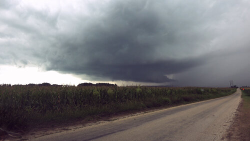
I had a visual on another developing cell to the east that was sporting a gorgeous base and wall cloud. Unwarned, but in totally clear air, "the grass is always greener" made me want to go after it, but I stuck with the mature tornado warned storm. It fell apart a short time later, which I expected given modest speed and directional shear. The east cell didn't last either. The atmosphere started to overturn, and the area turned into a sloppy mess. I wasn't going to call the chase just yet, but I wondered if that was going to be it for the day.
I targeted a new cell coming up out of the Jacksonville area, on the southern periphery of the ongoing convective activity. It had clean inflow off the warm sector. I arrived on the backside of the cell just in time to see it rapidly intensify with a wall cloud and prominent velocities and hook on radar. I thought for sure ILX would tornado warn it, but they didn't.
Supercell #2 just east of Jacksonville looking east-southeast:
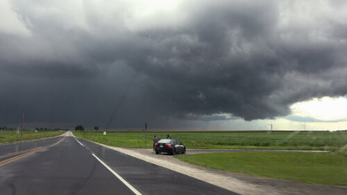
I hooked sliced this one on the road in the above photo, losing visibility on the area of interest only briefly. I emerged under the RFD gust front, which looked promising, menacing even as I got it front of it and turned around, but it was soon blasted by surging outflow and fell apart. Theme of the day it seemed.
CAMs hinted that the cells would continue to handoff to the southeast, the lead cell in the untapped inflow being dominant, so I kept moving downstream east and south trying to stay in the game and not get bogged down. A cell was developing to my east near Lake Springfield. Looking at the track, I decided my best bet to get ahead of it was to go up and around the cell using I-55 where it rounds the bottom of Springfield and highway 29, which runs southeast to Taylorville, both fast four lane divided highways.
Convective mode was a mess as I started the maneuver. Traffic backed up briefly on 55 due to some incident, and then I hit a painfully long and useless red light in Rochester before I was finally cruising southeast on 29. A tornado report came in for a multivortex tornado. The cell didn't look amazing on radar yet, but I could plainly see the cycle on reflectivity and imagined how it could have squeaked one out. Little did I know that it was the start of a long track tornado. ILX didn't warn the storm though.
I core punched the cell blasting southeast down 29, encountering some hail exceeding an inch. I broke out of the forward flank near Edinburg and got onto the grid driving due south for the intercept. The roads were maddeningly lined with trees though, and I wasted a few minutes hunting for a view before deciding I better just get back on 29 and try again further down.
The tornado had been ongoing for 15 minutes at this point, and on any other chase I would have simply missed the show. There was also still no tornado warning. Despite the traffic, red light, and jungle detour, I had managed to get well downstream of the storm just as the storm was peaking. I turned onto the grid once more, this time lined with 9 foot tall corn, but a large gravel lot allowed me to get away from the corn and look at the storm over a bean field.
Supercell #3 with ongoing tornado one mile south of Edinburg looking southwest at 6:25 pm:
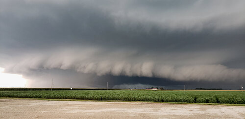
I stared at the prominent white gust front with a dark, ground dragging smudge underneath for some moments. At that distance and through the haze (photo is contrast enhanced) it finally sank in. "Oh, that's a tornado."
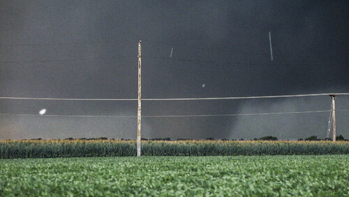
And maybe a big one, or the base was just so low it looked like a mini-wedge. My phone finally went off for a tornado warning right about this time, the radar now showing an extremely pronounced hook and couplet. According to the logs, the warning was 15 minutes late, and was for radar indicated rotation and a storm *capable* of producing a tornado. I tried to report the tornado via Spotter Network through Radarscope, but frustratingly the report was tagged to a location I was at an hour earlier. Several other chasers reported it and I could hear the sirens in Edinburg, so I figured folks were on top of it.
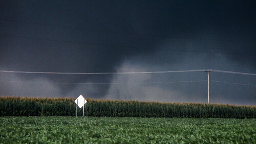
The condensation funnel was intermittent, going stretches with just a looming tornado cyclone aloft, and then entering a multivortex phase.
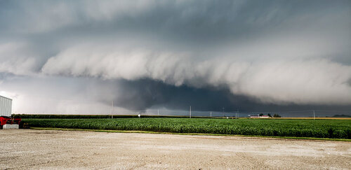
I was deep in the notch looking south-southwest. The tornado looked buried behind a huge RFD gust front, a ton of rain ahead of it to the east. I decided to just hold my ground and get a stable shot while I had a visual, not too keen on blasting in there for a closer look. I figured the whole thing might just fill in with rain rapidly while I was in the cage with a confirmed bear, or I'd lose my nice view and be driving through a 9 foot tall corn maze once again wondering where the thing was.
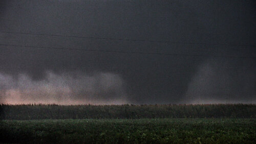
The storm was moving east-southeast and I was starting to get buried in rain from the forward flank and arm of the hook. I held until I completely lost visual though, the tornado appearing to be increasing in size as the contrast faded to zero.
And then I sat in the rain hemming and hawing about what to do next. Half of me wanted to aggressively get in there and reestablish a view, and the other half said just let it go. I decided to approach, but cautiously, heading southeast down 29 at 40 mph with my hazards on, hoping to reemerge in the notch or see some parent structure and meanwhile giving the velocity time to update. I was apprehensive of deviant left turning motion with not a lot of speed shear to keep this thing on course. The update came in and the couplet was just across 29. I pushed in a little harder now, more worried about debris in the road than the tornado. The southeast sky lightened and I could see the tornado cyclone to my left. I blasted southeast toward it, and the tornado emerged from the rain once more:
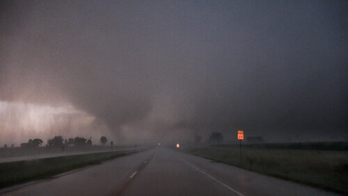
I got about even with it off to my due east before turning onto the grid to go after it. The rain just totally swallowed it, however.
I zig zagged south to Taylorville and then east again negotiating the grid and trying to get out of the core, but I was solidly stuck in it. I tried to push east through the RFD, hoping to come out the bottom of the cell, which at this point was merging into a huge line. However, the southeast motion put me squarely behind the circulation. A chaser passed me, but then stopped a short ways later. I tried to push on for a ways, but northwesterlies exceeding severe threshold told me I was driving into the back of the circulation, which at that point had just become totally swamped. There would be no view again. I aborted the intercepted, cut due south to see if Tail-End-Charlie on the line could do anything. It was a long shot, and as expected it was just gusting out, caught behind the line's outflow boundary. I called the chase and headed for home, back up highway 29. Curiously, I saw no damage where the tornado had crossed the highway.
Supercell #1 a few miles south of Beardstown, IL looking west-southwest:

I had a visual on another developing cell to the east that was sporting a gorgeous base and wall cloud. Unwarned, but in totally clear air, "the grass is always greener" made me want to go after it, but I stuck with the mature tornado warned storm. It fell apart a short time later, which I expected given modest speed and directional shear. The east cell didn't last either. The atmosphere started to overturn, and the area turned into a sloppy mess. I wasn't going to call the chase just yet, but I wondered if that was going to be it for the day.
I targeted a new cell coming up out of the Jacksonville area, on the southern periphery of the ongoing convective activity. It had clean inflow off the warm sector. I arrived on the backside of the cell just in time to see it rapidly intensify with a wall cloud and prominent velocities and hook on radar. I thought for sure ILX would tornado warn it, but they didn't.
Supercell #2 just east of Jacksonville looking east-southeast:

I hooked sliced this one on the road in the above photo, losing visibility on the area of interest only briefly. I emerged under the RFD gust front, which looked promising, menacing even as I got it front of it and turned around, but it was soon blasted by surging outflow and fell apart. Theme of the day it seemed.
CAMs hinted that the cells would continue to handoff to the southeast, the lead cell in the untapped inflow being dominant, so I kept moving downstream east and south trying to stay in the game and not get bogged down. A cell was developing to my east near Lake Springfield. Looking at the track, I decided my best bet to get ahead of it was to go up and around the cell using I-55 where it rounds the bottom of Springfield and highway 29, which runs southeast to Taylorville, both fast four lane divided highways.
Convective mode was a mess as I started the maneuver. Traffic backed up briefly on 55 due to some incident, and then I hit a painfully long and useless red light in Rochester before I was finally cruising southeast on 29. A tornado report came in for a multivortex tornado. The cell didn't look amazing on radar yet, but I could plainly see the cycle on reflectivity and imagined how it could have squeaked one out. Little did I know that it was the start of a long track tornado. ILX didn't warn the storm though.
I core punched the cell blasting southeast down 29, encountering some hail exceeding an inch. I broke out of the forward flank near Edinburg and got onto the grid driving due south for the intercept. The roads were maddeningly lined with trees though, and I wasted a few minutes hunting for a view before deciding I better just get back on 29 and try again further down.
The tornado had been ongoing for 15 minutes at this point, and on any other chase I would have simply missed the show. There was also still no tornado warning. Despite the traffic, red light, and jungle detour, I had managed to get well downstream of the storm just as the storm was peaking. I turned onto the grid once more, this time lined with 9 foot tall corn, but a large gravel lot allowed me to get away from the corn and look at the storm over a bean field.
Supercell #3 with ongoing tornado one mile south of Edinburg looking southwest at 6:25 pm:

I stared at the prominent white gust front with a dark, ground dragging smudge underneath for some moments. At that distance and through the haze (photo is contrast enhanced) it finally sank in. "Oh, that's a tornado."

And maybe a big one, or the base was just so low it looked like a mini-wedge. My phone finally went off for a tornado warning right about this time, the radar now showing an extremely pronounced hook and couplet. According to the logs, the warning was 15 minutes late, and was for radar indicated rotation and a storm *capable* of producing a tornado. I tried to report the tornado via Spotter Network through Radarscope, but frustratingly the report was tagged to a location I was at an hour earlier. Several other chasers reported it and I could hear the sirens in Edinburg, so I figured folks were on top of it.

The condensation funnel was intermittent, going stretches with just a looming tornado cyclone aloft, and then entering a multivortex phase.

I was deep in the notch looking south-southwest. The tornado looked buried behind a huge RFD gust front, a ton of rain ahead of it to the east. I decided to just hold my ground and get a stable shot while I had a visual, not too keen on blasting in there for a closer look. I figured the whole thing might just fill in with rain rapidly while I was in the cage with a confirmed bear, or I'd lose my nice view and be driving through a 9 foot tall corn maze once again wondering where the thing was.

The storm was moving east-southeast and I was starting to get buried in rain from the forward flank and arm of the hook. I held until I completely lost visual though, the tornado appearing to be increasing in size as the contrast faded to zero.
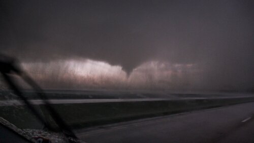
And then I sat in the rain hemming and hawing about what to do next. Half of me wanted to aggressively get in there and reestablish a view, and the other half said just let it go. I decided to approach, but cautiously, heading southeast down 29 at 40 mph with my hazards on, hoping to reemerge in the notch or see some parent structure and meanwhile giving the velocity time to update. I was apprehensive of deviant left turning motion with not a lot of speed shear to keep this thing on course. The update came in and the couplet was just across 29. I pushed in a little harder now, more worried about debris in the road than the tornado. The southeast sky lightened and I could see the tornado cyclone to my left. I blasted southeast toward it, and the tornado emerged from the rain once more:

I got about even with it off to my due east before turning onto the grid to go after it. The rain just totally swallowed it, however.

I zig zagged south to Taylorville and then east again negotiating the grid and trying to get out of the core, but I was solidly stuck in it. I tried to push east through the RFD, hoping to come out the bottom of the cell, which at this point was merging into a huge line. However, the southeast motion put me squarely behind the circulation. A chaser passed me, but then stopped a short ways later. I tried to push on for a ways, but northwesterlies exceeding severe threshold told me I was driving into the back of the circulation, which at that point had just become totally swamped. There would be no view again. I aborted the intercepted, cut due south to see if Tail-End-Charlie on the line could do anything. It was a long shot, and as expected it was just gusting out, caught behind the line's outflow boundary. I called the chase and headed for home, back up highway 29. Curiously, I saw no damage where the tornado had crossed the highway.
Last edited:

