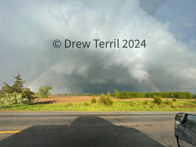
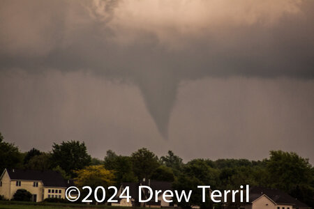
2024-05-07 REPORTS: MI/OH/IN

Joined
Mar 4, 2004
Messages
145
Location
Kalamazoo, Michigan
Wowzers! Today's forecast verified almost on top of my family's homestead in Texas Township, Michigan.

Observed a large, significant tornado develop just to the southwest of Texas Corners, Michigan near the 8th Street and S Avenue location between apx. 5:45-5:50 p.m. ET. Blasted east and then north on US 131 at Center Street in Portage, Michigan [Southern Kalamazoo County, MI] just in time to see a large tornado develop less than a mile to my southwest. Then jumped north on US 131, east on I-94 and then exited south on Westnedge Avenue in Portage, Michigan at 6 p.m. A large and destructive tornado soon came into view just to the southwest and tracked east/northeast along Center Street, just behind the Crossroads Mall area [for those familiar] and continued east. This video still was taken around 6:05 p.m. ET in Portage, Michigan

The large vortex continued east, likely south of the Kalamazoo-Battle Creek International Airport. From reports and images, looks like a FedEx plant took a direct hit with reports of people trapped inside along with some other businesses and residential areas. Visual EF-2/EF-3 damage apparent at FedEx per a photo from a friend. The supercell/mesocyclone cycled again along I-94 between Galesburg and Climax, crossed I-94 east of Climax and continued into Calhoun County, where at that time I stopped pursing the storm east, with debris raining down [roofing, siding, tree branches, leaves]. Hope nobody was seriously injured or worse with this event.

This is the first time in 44 years that a series of significant tornadoes in Kalamazoo County, Michigan transpired. The last being the May 13, 1980 F3 killer Kalamazoo tornado, of which was the keynote event that first got me interested in meteorology, tornadoes and severe thunderstorms. Synoptically the warm frontal boundary setup today was very similar to the 1980 event. Today's event was also synoptically suggested on the GFS and Euro medium range runs a week out with assorted geospatial variances. This was also the first time I've ever observed a tornado in Michigan, oddly it was also in my hometown!

Full video to follow soon on my YouTube channel.

Another significant tornado was reported near the Union City, Michigan in Branch County to the southeast of the Kalamazoo County tornado. Curious what transpired there.
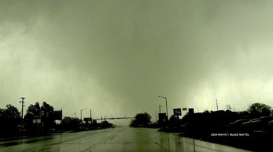

2024_0507_PortageMITornado_605p.png
 
Last edited:
decided to end my chase early. nothing too exciting happened in my area of Central IN. at least nothing I could see. Chased the cell over Frankfort when it and I met up in Kirklin. continued to chase until Elwood when I needed to stop and get gas. ultimately I decided to quit following it after Elwood just because I figured continued going East past Anderson and Muncie would've made it a little more difficult to make it home in a timely manner since I have work tomorrow morning. After keeping an eye on another storm South of Anderson as it moved Northeast, I decided to head on home since it looked a little messy. I'm not sure if I should call this a "bust" for me. I mean, sure I'm a little disappointed with the storms around the Kokomo area, but I wasn't honestly expecting to see a tornado with the first cell I was chasing. Too HP. But in the end, I did get pictures, though they don't really "Wow" me. I'll be sure to post those in the report thread after I do some edits tomorrow.
 
I trusted my gut and went north where the surface winds were still backed. Ended up with 3 for sure for the day. One near Fremont, IN, one near Ransom, MI, and the final one near Paulding, OH. Long story short, hauled balls up I-69. Had the storm near Three Rivers not gotten the zooms and accelerated from 25 to 45, I was en route to get it. But then the cell near Fremont went up, and I followed it into MI. Saw the first tornado from that right before I got onto IN-120 (and heard confirmation over the scanner so I knew I wasn't seeing things). The second I saw after the first storm went through a merger that basically killed off that meso. I had just turned around to go south on M-99 when I saw the lowering. Found a place to park and watched that till the base got completely rain wrapped. Then headed south into OH where I got to Paulding just as that storm (that had been tornado warned since Fort Wayne) dropped a gorgeous cone out in the middle of nowhere.

Biggest lesson out of that? One that I continue to remind myself (and that we've discussed in some recent threads on this forum). Trust your gut. I've been doing this for nearly 2 decades and still have to remind myself to trust my gut.
 
Followed an on-again off-again tornado warned cell from Fairmount Indiana into Mercer County Ohio before storm motion became too fast and darkness took over. Saw a nice meso as it went into Ohio and then it became blocked/enveloped in rain. There could have been a tornado in there or maybe what I thought was a mesocyclone was actually it. For a day when I couldn't go far I was happy: I was rewarded for staying on the storm with some nice structure and great sunset. The best part was hanging out with my teenage son for a few hours (plus he drove). :)
 
Had a chance to get what few pics I got onto the computer. I wasn't able to get anything picture wise of the first tornado as I was still on I-69.

This picture was taken probably 5 minutes after tornado 2 for the day. This was probably the last gasp for this particular meso. Rain curtains were definitely wrapping around in the middle of the shot, but I don't believe anything was down at this point (not that I could see well enough into the bear cage to know if anything was in fact down).

IMG_0864.JPG

This one was one of my better tornado shots that I've had over my time chasing, although I doubt I'll ever get anything that matches Forgan, OK from 5/17/19. That was a textbook classic tornado that I doubt I'll ever top. This certainly tops Minneola in my eyes from 5/17/19 though. Yesterday, IWX released their survey results and this one, east of Paulding, OH, ended up receiving an EF1 rating.

IMG_0812.jpg


All in all, pretty solid day for me. Had I kept going north for the storm in northern Branch County, I doubt I would have been able to drop down in time to get the Paulding tornado. That said, I probably would have left earlier had I not waited for my gf to finish up with work, so everything worked out in the end, and she was able to get her first three tornadoes, as well as her first wall hanger.

I did get some shots with my film SLR as well, but I still have to finish up that roll before I can get it developed.
 
I had just returned from Plains trip #3 at 2:00pm, and was only home for 30 minutes before leaving to cover this event. I could not make the best area in northern/central Indiana/southern Michigan in time, but the southern extent of the event along I-64 would not be firing until late afternoon and therefore would be within reach. I headed to the Fairfield exit east of Mount Vernon and watched agitated cumulus begin developing into a few showers. These were struggling to take off. Meanwhile, a much more robust cell was getting started east of Evansville, Indiana, and looked like a viable play. If the western activity did take off, it would be easy enough to go back to get it. The Evansville storm began looking healthy as I approached it at Ferdinand:

may724d.jpg


The storm turned right just before the meso crossed I-64, staying just south of the interstate. I made it under the storm at Sulphur in the heart of the Hoosier National Forest, one of the worst places on I-64 to intercept a storm. Nonetheless, I had a view of the base and wall cloud, which was visibly rotating with fast pre-tornadic motion in cloud tags at its base.

may724e.jpg


Less than a minute after I stopped, a weak tornado spun up under the wall cloud to the southwest of the Sulphur/English exit.

may724a.jpg


The mesocyclone tracked generally right along the interstate eastward. I had some great views looking up through the RFD clear slot with the meso just to the north, but low-level motion was weak.

may724f.jpg


Meanwhile, a new supercell just to the north produced a highly visible tornado near Sellersburg. My supercell's structure with a clear slot remained even as the storm continued weakening. This funnel-like feature appeared at Lanesville, but motion was very weak.

may724g.jpg


Models had indicated that supercells would develop back to the west near Evansville. So as my storm's reflectivity continued to fade, I let it go and returned west to Warrenton as new storms developed to the south and southwest. These quickly went linear with no supercell structure, so I didn't keep after them. I stopped to the north of a cell at Haubstat to shoot some of the lightning in the cores, catching a couple on stills:

may724b.jpg


may724c.jpg


No stratiform region was developing, so there was no opportunity for sprites or upward lightning as the storms moved away. I made it back home at 2AM.
 
I was right on the supercell that formed by South Bend. I did everything right except made 1 minor road navigation error that lead to me being behind the ef2 tornado that hit Union City, etc in southern Michigan. As a result I was hook slicing for damn near an hour and was never able to get visual on it, only seeing the hail and damage it left behind. Super frustrated.
 
Back
Top