cdcollura
EF5
Good day all, Here is my report for storms for June 18, 2019...
Chase Summary: June 18 was another long chase day but awarded with two brief tornadoes on south-central / central Kansas at the end of the day, these being the only tornadoes of the day, despite the SPC having an enhanced outlook with a 10% tornado, 30% wind, and 30% significant hail in their probabilities. The target area and forecast was quite complex, with supercell storms being attributed to a MCV (mesoscale convective vortex) moving across central Kansas surrounded by mainly wind and hail probabilities. The Enhanced risk (13z and 1630z issued by the SPC) stretched from NE Kansas to SW Texas! I began the day by leaving Amarillo and taking Highway 60 off I-40 east and northeast of town. I used SR 152 east to go around major construction delays on Highway 60, then north on FM 748 to resume Highway 60 east of Miami, Texas. I entered Oklahoma, then took Highway 283 and SR 15 to Woodward, Oklahoma. Out of there, I headed up to via SR 34 to SR 1 off Highway 64 through Coldwater, Kansas, and Highway 183 from there with a primary target area anywhere north and west of Pratt, Kansas. I stopped in Greesburg and once again met up with chasers including Dan Shaw and Greg Ansel for lunch at the Subway as well as a fuel stop. The SPC issued Mesoscale Discussion 1116 and eventually tornado watch box 935 valid until 10 PM CDT. A developing supercell I was watching on the way up matured and quickly became severe, and we hastily left (carrying out our sandwiches) and headed back up Highway 183 to Kinsley, Kansas just in time to see two brief tornadoes from about 5 to 10 miles out. We headed east on Highway 50 to near Macksville as the storm weakened and attention turned to another supercell storm near Medicine Lodge and Harper. I took Highway 281 south to Pratt, then east on Highway 54 / 400, dropping south through Murdock to SR 42, then east and south towards Argonia. The storm remained multicellular and no tornadoes were produced. I wrapped up by heading east to Wellington on Highway 160, then south on Highway 81 / 177 back into Oklahoma to observe another supercell that appeared to be weakening to the southeast near Ponca City. I continued south on I-35 out of Bramen, and continued to Oklahoma City for the night.
Storm Interception Details Are Below
1). June 18, 3:00 PM - Interception, penetration, and observation of a very severe and tornadic thunderstorm to the northwest of Kinsley, Kansas in Hodgeman and Edwards Counties from near Highways 50 and 183 and west of Highway 56. The storm was a classic supercell storm, and two brief tornadoes were observed from a distance of about 5 to 10 miles as the storm was approached from the southeast. A large wall cloud with funnels was also observed, as well as a gust front extending from the RFD region and southwestward (this meant the storm was "anchored" on an outflow boundary). The storm also contained lightning, heavy rains, 50 MPH winds, and large hail, but the core was not penetrated. Some tree damage was noted after the storm became outflow dominant and began down-scaling, most likely from one of the brief tornadoes, and / or RFD winds. One tornado was an elephant trunk type, while the other was a thin needle type. Documentation was digital stills and HD video. Conditions causing the storms were surface heating, an outflow boundary, a low pressure area (particularly an MCV), and upper trough. A 2016 Jeep Wrangler was used to chase the storms. A tornado watch was also in effect for the area until 10 PM CDT.
2). June 18, 6:00 PM - Observation and indirect penetration of very strong and severe thunderstorms in Sumner County, Kansas from north of Conway Springs and east of Harper, and along Highways 54 and 160 to near Wellington. The storm was originally a supercell storm, but it became outflow dominant and was mainly a large multicell cluster at the southwestern end of a squall line. Small hail to marble sized, 60 MPH winds, lightning, and very heavy rains were encountered with these storms. Street / flash flooding was also encountered. Documentation was digital stills. Conditions causing the storms were surface heating, an outflow boundary, a low pressure trough, and upper trough. A 2016 Jeep Wrangler was used to chase the storms. A tornado watch was also in effect for the area until 10 PM CDT.
Pictures For June 18, 2019 Are Below
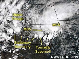
Above: This is a visible satellite image of the synoptic environment as of 22z on June 18, 2019. Important features are annotated with a mesoscale convective vortex crossing Kansas and a surface boundary providing the stream-wise vorticity for a tornadic supercell storm.
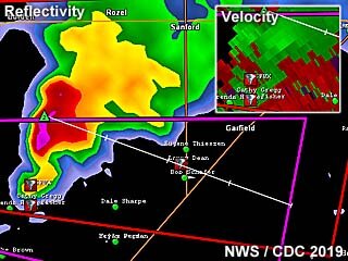
Above: Base reflectivity radar image of a tornadic supercell storm over Hodgeman and Edwards Counties, Kansas during the afternoon of June 18. The classic supercell signature is shown, with the velocity to the upper-right. Storm spotter network icons also appear on this image.
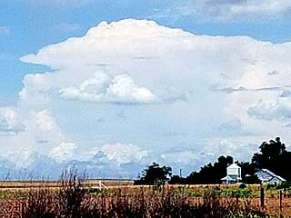
Above: The chase is on! In the distance, a developing supercell can be seen looking northwest of Greensburg, Kansas on June 18. This storm will quickly become severe and produce some brief tornadoes later near Kinsley.
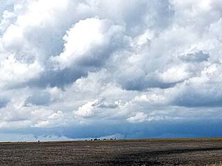
Above: Approaching a tornadic supercell (about 10 to 15 miles away) near Kinsley, Kansas during the afternoon of June 18. The view is towards the northwest and a tornado is visible on the ground just to the right of the lower-center of the picture.
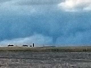
Above: Closer view of a brief tornado on the ground (from a distance of 5 to 10 miles) while closing in on a classic supercell storm near Kinsley, Kansas during the afternoon of June 18.
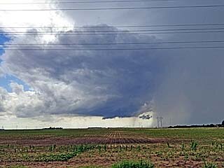
Above: View of formerly tornadic supercell storm east of Kinsley, Kansas on June 18. Looking west, the wall cloud and updraft structure can be seen.
Note: For DETAILS on this storm / setup as well as others in June 2019 … Please visit the link BELOW for more information!
Chase Summary: June 18 was another long chase day but awarded with two brief tornadoes on south-central / central Kansas at the end of the day, these being the only tornadoes of the day, despite the SPC having an enhanced outlook with a 10% tornado, 30% wind, and 30% significant hail in their probabilities. The target area and forecast was quite complex, with supercell storms being attributed to a MCV (mesoscale convective vortex) moving across central Kansas surrounded by mainly wind and hail probabilities. The Enhanced risk (13z and 1630z issued by the SPC) stretched from NE Kansas to SW Texas! I began the day by leaving Amarillo and taking Highway 60 off I-40 east and northeast of town. I used SR 152 east to go around major construction delays on Highway 60, then north on FM 748 to resume Highway 60 east of Miami, Texas. I entered Oklahoma, then took Highway 283 and SR 15 to Woodward, Oklahoma. Out of there, I headed up to via SR 34 to SR 1 off Highway 64 through Coldwater, Kansas, and Highway 183 from there with a primary target area anywhere north and west of Pratt, Kansas. I stopped in Greesburg and once again met up with chasers including Dan Shaw and Greg Ansel for lunch at the Subway as well as a fuel stop. The SPC issued Mesoscale Discussion 1116 and eventually tornado watch box 935 valid until 10 PM CDT. A developing supercell I was watching on the way up matured and quickly became severe, and we hastily left (carrying out our sandwiches) and headed back up Highway 183 to Kinsley, Kansas just in time to see two brief tornadoes from about 5 to 10 miles out. We headed east on Highway 50 to near Macksville as the storm weakened and attention turned to another supercell storm near Medicine Lodge and Harper. I took Highway 281 south to Pratt, then east on Highway 54 / 400, dropping south through Murdock to SR 42, then east and south towards Argonia. The storm remained multicellular and no tornadoes were produced. I wrapped up by heading east to Wellington on Highway 160, then south on Highway 81 / 177 back into Oklahoma to observe another supercell that appeared to be weakening to the southeast near Ponca City. I continued south on I-35 out of Bramen, and continued to Oklahoma City for the night.
Storm Interception Details Are Below
1). June 18, 3:00 PM - Interception, penetration, and observation of a very severe and tornadic thunderstorm to the northwest of Kinsley, Kansas in Hodgeman and Edwards Counties from near Highways 50 and 183 and west of Highway 56. The storm was a classic supercell storm, and two brief tornadoes were observed from a distance of about 5 to 10 miles as the storm was approached from the southeast. A large wall cloud with funnels was also observed, as well as a gust front extending from the RFD region and southwestward (this meant the storm was "anchored" on an outflow boundary). The storm also contained lightning, heavy rains, 50 MPH winds, and large hail, but the core was not penetrated. Some tree damage was noted after the storm became outflow dominant and began down-scaling, most likely from one of the brief tornadoes, and / or RFD winds. One tornado was an elephant trunk type, while the other was a thin needle type. Documentation was digital stills and HD video. Conditions causing the storms were surface heating, an outflow boundary, a low pressure area (particularly an MCV), and upper trough. A 2016 Jeep Wrangler was used to chase the storms. A tornado watch was also in effect for the area until 10 PM CDT.
2). June 18, 6:00 PM - Observation and indirect penetration of very strong and severe thunderstorms in Sumner County, Kansas from north of Conway Springs and east of Harper, and along Highways 54 and 160 to near Wellington. The storm was originally a supercell storm, but it became outflow dominant and was mainly a large multicell cluster at the southwestern end of a squall line. Small hail to marble sized, 60 MPH winds, lightning, and very heavy rains were encountered with these storms. Street / flash flooding was also encountered. Documentation was digital stills. Conditions causing the storms were surface heating, an outflow boundary, a low pressure trough, and upper trough. A 2016 Jeep Wrangler was used to chase the storms. A tornado watch was also in effect for the area until 10 PM CDT.
Pictures For June 18, 2019 Are Below

Above: This is a visible satellite image of the synoptic environment as of 22z on June 18, 2019. Important features are annotated with a mesoscale convective vortex crossing Kansas and a surface boundary providing the stream-wise vorticity for a tornadic supercell storm.

Above: Base reflectivity radar image of a tornadic supercell storm over Hodgeman and Edwards Counties, Kansas during the afternoon of June 18. The classic supercell signature is shown, with the velocity to the upper-right. Storm spotter network icons also appear on this image.

Above: The chase is on! In the distance, a developing supercell can be seen looking northwest of Greensburg, Kansas on June 18. This storm will quickly become severe and produce some brief tornadoes later near Kinsley.

Above: Approaching a tornadic supercell (about 10 to 15 miles away) near Kinsley, Kansas during the afternoon of June 18. The view is towards the northwest and a tornado is visible on the ground just to the right of the lower-center of the picture.

Above: Closer view of a brief tornado on the ground (from a distance of 5 to 10 miles) while closing in on a classic supercell storm near Kinsley, Kansas during the afternoon of June 18.

Above: View of formerly tornadic supercell storm east of Kinsley, Kansas on June 18. Looking west, the wall cloud and updraft structure can be seen.
Note: For DETAILS on this storm / setup as well as others in June 2019 … Please visit the link BELOW for more information!
