• A friendly and periodic reminder of the rules we use for fostering high SNR and quality conversation and interaction at Stormtrack: Forum rules

    P.S. - Nothing specific happened to prompt this message! No one is in trouble, there are no flame wars in effect, nor any inappropriate conversation ongoing. This is being posted sitewide as a casual refresher.

2019-05-20 REPORTS: OK/TX

Joined
Aug 9, 2012
Messages
585
Location
Macomb, IL
Targeted Hollis, OK area for supercell development this afternoon. Waited on the Oklahoma side for the Paducah, TX supercell to cross similar to my strategy on the Elmer day in 2015. I documented a funnel cloud that may or may not have touched down. It was too difficult to tell thanks to the awful terrain. Another spotter reported a funnel 3/4 the way down at the same time, so I'm sure it was at least a funnel and I saw condensation getting lifted from the ground, but I'm still unsure it was a tornado. A for sure tornado touched down to my south of Hollis and lasted for 3 minutes or so as an elephant trunk before roping out in a quite cool manner. The roads turned into a mess and we were driving in a Toyota Camry and got stuck for probably 20 minutes, which put us behind the storm. I had to push the car for 2-3 miles and had an asthma attack as a result; rolled my ankle. We caught up, but the massive hordes of chasers prevented me from getting a view of the Mangum, OK tornado. I possibly saw the right edge of it, but hard to say it was the tornado, and I'm not gonna claim it. Annoying how many people were on the roads, but I guess that is modern chasing in Oklahoma. Last time I'll probably ever chase down here. Here are a few shots from today. I screwed up the shots of the tornado because my camera was out of focus, another failure on the day. Overall I'm disappointed with how I played the day, another let down in 2019 for me and just a miserable chase honestly. I'm glad nobody got hurt though. Very grateful for that.


EDIT: Not sure why the first image didn't upload correctly. Sorry about that. Its attached at the bottom as a file attachment. Nothing too spectacular though.

View attachment 18199

18200

18201

18202
 

Attachments

  • DSC_9320 copy.jpg
    DSC_9320 copy.jpg
    857 KB · Views: 0
I saw two tornadoes whilst chasing the "Paducah" storm. The first photo is the first tornado, and I shot this at 2003Z. The second one is a vidcap, from a little later (10 minutes?) These pics are crappy as heck, but I'm posting them for the benefit of anyone who wonders what they looked like, since I have noticed that nobody else has posted pics/vids of these tornadoes. There were other chasers on these, though, so other pics/vids are out there somewhere. I would estimate that each tornado's duration was 3 or 4 minutes.DSC00214.JPGPaducahVidcap.PNG
 
Last edited:
This is my first post here and I’m excited. I took off work half a day yesterday and drove from Joplin to Midwest City. Right as the cell near Union City/El Reno went up, I headed north and caught it west of Crescent as both tornadoes were on the ground. Unfortunately the soupy roads and speed of the storms kept me from catching back up but it was not a terrible day chasing and I was back home and in bed in Missouri by bedtimeC77B9028-71CA-45F1-BF1E-AE31120E4E32.jpeg6C5A9FDA-563A-4F8D-B87B-8A4C777780FB.jpeg99188E18-61BB-4E6D-9FC4-D70E5DA848F1.jpeg
 
Last edited:
I ended up having a pretty good chase considering how underwhelming the setup ended up being. I targeted Childress and got on the storm coming up from Post around the time it reached Paducah. It ended up producing the first tornado of the day for me.
18223

I stayed with the storm as it looked like it may be the only storm to stay isolated. I stayed ahead of it and it appeared to weaken for a bit, but I had hopes it would eventually strengthen and it was my only shot at something isolated. It did start to strengthen as it approached Mangum and I made my play on it. It ended up producing my second tornado of the day.
18224

Overall a pretty solid day. I didn’t experience much in the form of convergence. I think I may have just lucked out with my timing and positioning. After the many challenging chases over the last couple years with minimal results, I needed this.
 
I waited for the storm coming up from Post in Dickens TX. I was concerned because of how early it popped up and it seemed slow to gather strength. After letting it slide by on HWY 70, I spent the rest of the day in a futile effort to get in position again, eventually giving up in Hobart OK. No pictures worth posting, but I did get a crappy view of the Magnum tornado through the rain.
 
I started the day in San Angelo, TX and headed north on US 277/ TX 70 at around 2pm. My initial target was around Sweetwater, TX, but after a quick radar check I moved on up north to Snyder, TX on US 84. I held there for about 15 minutes and then pushed up 84 towards Post. The first storm crossed 84 just south of Post and I was in decent position, but it wasn't doing much of anything. I might have seen a brief funnel, but I wasn't sure enough to report it. I'll have to check back through my gopro dash footage on that one.

After allowing the storm to pass, I went north into Post and then east on US 380 to get back into position. I turned north on county road 2008 and the storm seemed to be getting it's act together a little bit. Unfortunately I started smelling gear oil and could feel a lot of heat coming from around my shifter (I drive a stick shift). So I pulled over to try and let it cool off, and on radar I noticed another cell coming up from the WSW (ish) which put me in the path of that hail core. So I had to bail on the storm I was on (apparently right before it produced near Dickens), and head back south to US 380. I pulled over at the intersection of CR 2008 and US 380, checked the transmission gear oil (which was full) and headed east on 380 to get ahead and out of the way of the storms coming, in case I broke down.

I kept east on 380 and then turned south on TX 208. I was pretty much just heading back to San Angelo at this point and calling it a day. Strangely enough (and a bit annoying as well depending on the way you look at it) the transmission heat/ gear oil smell never returned the whole way down 208. So when I got into Snyder again, I topped off my fuel and rechecked the trans fluid. Around this time the two storms were coming up from around Midland toward the Colorado City area along I-20. So instead of heading home, I turned west on I-20.

I stayed on I-20 until I was somewhere between Colorado City and Westbrook, and hopped off onto the service road. I got some cool shots (in my opinion) of the meso on the northern storm as it came by with some interesting colors from the impending sunset. I even got a pretty neat time-lapse (again, at least in my opinion). Also on this one, I once again thought I saw a brief funnel, but I couldn't be sure enough to report it, and after looking back through my images I couldn't find any evidence of it. It was probably a mix of wishful thinking and my imagination. At this point the storm that had produced near Forsan, TX was heading my way, so I headed back east on I-20 and turned south on 208 to avoid the hail core of that storm. I kept south on 208 for a bit and then turned back north to try and see what I could as the storm moved across the highway. But alas, darkness had finally caught up with me and so I called it off and headed south on 208 back to San Angelo. I got home around 10pm.

After about 8 hours, a little over 400 miles driven, and 0 tornadoes, I am actually pretty happy with, and dare I say even proud of, this chase. When I would chase several years ago I never did much forecasting for myself. I would wake up the day of, try to get to the SPC risk area and then essentially polygon chase. Frankly, I was young and didn't know any better. Needless to say I never had much luck. Here lately though, being a bit older and hopefully a bit wiser, I have been trying to learn all I can about forecasting and use of the numerical models and feeding all of that into my decisions on a target area. So over all I would say yesterday was a success for me. I learned a lot, I managed to put myself into a pretty good position a couple of times, and I chased safely and courteously. The storms just weren't producing when I was in position. Then of course the car trouble thing up between Post and Dickens, which may well have cost me a tornado, but can't ever know for sure. It still has me frustrated though and even a bit confused because the issue didn't come back the entire rest of the trip.

Once I get all the images, videos and time lapses off my gopro ( unfortunately I don't have any other camera besides the gopro and my cell phone at the moment) I will post the best ones up.
 
Targeted Hollis waiting for the warm sector storms to start going. When it became evident this was not going to occur, I dropped down to the storm at Paducah, Texas just in time to watch it produce a small ten-minute plus long tornado. The tornado lingered for a very long time in a rope stage, refusing to die.

may2019a.jpg

The RFD had carved a long clear slot into the storm's base, but only the trailing occlusions stayed interesting. The southwestern-most one produced another small tornado just west of Highway 62, with a swirl of debris at the ground and a partially-condensed funnel hanging in midair:

may2019b.jpg

I stayed with the storm until just north of Kirkland, a couple of miles before the Red River crossing. My map showed CR S as a highway that continued to the bridge. The road turned to dry dirt (OK), then suddenly soft sand (not OK). My wheels fell into the ruts and I high centered the car. The sand was easy enough to dig by hand, just like at the beach. But after 30 minutes of digging, I was making no headway. I called a towing company in Childress, but they refused to come out, saying they too would get stuck - then hung up on me before I could say the road was still dry. Storms to the west were about 45 minutes away. If I could not get out before it rained, I was in big trouble (likely a 24-36 hour camp out waiting for a farmer's tractor). 15 minutes later, a local resident came by with a 4WD SUV and with my tow strap, pulled me the 500 feet back to solid ground. The reverse tow tore off my exhaust heat shield, which dragged on the pavement despite my best efforts to dislodge it. I was extremely thankful to be back on the road, the ordeal certainly could have been many orders of magnitude worse and expensive!

At that point, my only other option was the supercell moving toward Guthrie. It beat me across the highway south, and after that my chase was over. Ended the day in Lawton.
 
We looked everywhere and could not find anything here's a photo of me looking ...
1.jpg

OK ....we targeted Wellington Texas and sat there catching up with chasers until the cells started to fire south of us. We got on the cell that dropped the two by Paducah ....
2.jpg3.jpg

We got caught up in the chaser convergence yet still got a blah glimpse of the Magnum tornado
5.jpg

Not a bust for us but not what we thought this day would be ... on to next ...
 
Targeted Childress, and then moved north a bit across the Red River and waited for initiation. Once I saw the storms go up to the south near Paducah I attempted to drive south to intercept them, but unfortunately the road options were limited and I didn't want to risk getting cored by potential giant hail so I decided to wait on Road 287 for the storm to move north. The storm then began to fall apart around the time it was reaching the Red River so I took the opportunity to cross north of Quanah and headed north towards El Dorado. Making this move actually placed me well ahead of the chaser horde coming up from the south so I had little issue positioning.

While driving north, I noticed a small cell go up just south of the main supercell and began to suspect a rear flank merger was imminent so I continued north towards Mangum to position ahead of the storm. Sure enough, once the merger completed the storm ramped up and produced the Mangum tornado. During the tornado I didn't have much issue with chaser convergence, but after passing through Mangum I ran into the giant conga line while trying to get out of the RFD. Very frustrating chase, but happy I didn't come out of it empty handed.
 

Attachments

  • IMG_20190520_190442_203.jpg
    IMG_20190520_190442_203.jpg
    138 KB · Views: 1
  • IMG_20190520_172433.jpg
    IMG_20190520_172433.jpg
    116 KB · Views: 0
There was a massive amount of blowing dust and dust in the air which caused a brownish haze... along with the high humidity I assume. I was worried about finding a tornado at all in that driving West on 180 from Snyder to Lamesa. I got under the first storms that fired there and up toward Tahoka and the dust settled down some. Fell behind those storms at Spur with a road hole and closed highway north of Spur. Dropped south to a few more storms, one of which was warned for a confirmed tornado as the meso passed directly over me. That got my heart pumping. I doubted the report but also afraid I was just missing it. No tornadoes but overall I'm glad I picked the area I did. I wish I had just gone on down to Odessa and set there all evening. Could have watched sups develop again and again, with tornadoes, at least one very photogenic tornado, and not moved more than 25 miles. Instead i caught the storms further down stream after they had become mushy or more HP. But I was not initially worried about that considering environment sustaining supercells with long trackers in the forecast. That is three times this year I have picked a good general area and missed tornadoes because they occurred so quickly at initiation.
 
We launched a radiosonde into the storm west of Paducah, TX, right after the second tornado lifted off the ground. We were near the location where the first weak tornado crossed the main road west of Paducah and the balloon was released between the two circulations that were present at the time. It flew on the rear side behind the core, encountered lots of hail below the anvil, then was absorbed by the anvil and flew over FFD where it encountered heavy snow and hail/graupel. The sonde then descended to around 1000 metres due to icing (which stopped data recording temporarily and video recording permanently) before it re-ascended to near 10.000 metres after which it overtook the storm and landed in a field a few miles ENE of Mangum, where strong tornadoes were reported. Unfortunately, the GoPro wasn't recording by then, but radiosonde data was being logged again by then. We recovered the right as a shelf-cloud passed over us a few hours after it landed. Data is attached. Feel free to share and use for scientific purposes as long as you mention my name (Miroslav Provod). Go Pro video was uploaded and shared via my Facebook page: Miroslav Provod
 

Attachments

  • EAGLE029.TXT
    171 KB · Views: 0
Started the day in Childress, Texas with several chaser friends. When storms started to fire there was some debate about whether to go north to Oklahoma right away to take the river out of the equation early or to stay south and worry about crossing the river later. Didn't want to miss something happening before the storm crossed into Oklahoma so we decided on the latter. Dropped a little south and east of Childress and saw some rotation while there were two discrete storms, but not the first rope. Then crossed the river at Quanah, Tx and made our way towards a planned intercept at Mangum. Made a timely intercept - saw a low contrast cone to the west as we were nearing Mangum from the south and then a little later got these shots on 283 headed north in Mangum. Then went over to the 6 and headed north towards Granite with the hoards. Despite some questionable driving decisions by chasers and police alike, finally got headed east on 9 out of Granite. Got just a little dicey around Lone Wolf when we were in RFD outflow with one area of circulation to our NE and looking like another meso might be trying to form to our SE. By the time we got to just north of Hobart the storm appeared to be gusting out and we abandoned it.
 

Attachments

  • IMG_1099.JPG
    IMG_1099.JPG
    119.9 KB · Views: 0
  • IMG_1100.JPG
    IMG_1100.JPG
    116.9 KB · Views: 0
I started the day in San Angelo, TX and headed north on US 277/ TX 70 at around 2pm. My initial target was around Sweetwater, TX, but after a quick radar check I moved on up north to Snyder, TX on US 84. I held there for about 15 minutes and then pushed up 84 towards Post. The first storm crossed 84 just south of Post and I was in decent position, but it wasn't doing much of anything. I might have seen a brief funnel, but I wasn't sure enough to report it. I'll have to check back through my gopro dash footage on that one.

After allowing the storm to pass, I went north into Post and then east on US 380 to get back into position. I turned north on county road 2008 and the storm seemed to be getting it's act together a little bit. Unfortunately I started smelling gear oil and could feel a lot of heat coming from around my shifter (I drive a stick shift). So I pulled over to try and let it cool off, and on radar I noticed another cell coming up from the WSW (ish) which put me in the path of that hail core. So I had to bail on the storm I was on (apparently right before it produced near Dickens), and head back south to US 380. I pulled over at the intersection of CR 2008 and US 380, checked the transmission gear oil (which was full) and headed east on 380 to get ahead and out of the way of the storms coming, in case I broke down.

I kept east on 380 and then turned south on TX 208. I was pretty much just heading back to San Angelo at this point and calling it a day. Strangely enough (and a bit annoying as well depending on the way you look at it) the transmission heat/ gear oil smell never returned the whole way down 208. So when I got into Snyder again, I topped off my fuel and rechecked the trans fluid. Around this time the two storms were coming up from around Midland toward the Colorado City area along I-20. So instead of heading home, I turned west on I-20.

I stayed on I-20 until I was somewhere between Colorado City and Westbrook, and hopped off onto the service road. I got some cool shots (in my opinion) of the meso on the northern storm as it came by with some interesting colors from the impending sunset. I even got a pretty neat time-lapse (again, at least in my opinion). Also on this one, I once again thought I saw a brief funnel, but I couldn't be sure enough to report it, and after looking back through my images I couldn't find any evidence of it. It was probably a mix of wishful thinking and my imagination. At this point the storm that had produced near Forsan, TX was heading my way, so I headed back east on I-20 and turned south on 208 to avoid the hail core of that storm. I kept south on 208 for a bit and then turned back north to try and see what I could as the storm moved across the highway. But alas, darkness had finally caught up with me and so I called it off and headed south on 208 back to San Angelo. I got home around 10pm.

After about 8 hours, a little over 400 miles driven, and 0 tornadoes, I am actually pretty happy with, and dare I say even proud of, this chase. When I would chase several years ago I never did much forecasting for myself. I would wake up the day of, try to get to the SPC risk area and then essentially polygon chase. Frankly, I was young and didn't know any better. Needless to say I never had much luck. Here lately though, being a bit older and hopefully a bit wiser, I have been trying to learn all I can about forecasting and use of the numerical models and feeding all of that into my decisions on a target area. So over all I would say yesterday was a success for me. I learned a lot, I managed to put myself into a pretty good position a couple of times, and I chased safely and courteously. The storms just weren't producing when I was in position. Then of course the car trouble thing up between Post and Dickens, which may well have cost me a tornado, but can't ever know for sure. It still has me frustrated though and even a bit confused because the issue didn't come back the entire rest of the trip.

Once I get all the images, videos and time lapses off my gopro ( unfortunately I don't have any other camera besides the gopro and my cell phone at the moment) I will post the best ones up.

So my laptop decided to literally die. However I was able to get a few screenshots from videos using my gopro app, plus the best shots from my cell phone. The first 3 photos are of what I am now pretty sure was a funnel. All 3 are grabs from my dash video. First of the 3 was on 84 just south of Post, the other 2 are just east of Post on 380 near the municipal airport.

The next photo is just looking back west as I was moving south on 208. Just thought it was a cool shot.

The remaining photos are from the later storm along I-20 just to the north of the interstate between Colorado City and Westbrook. Unfortunately no timelapse due to the laptop failureGH010034_1558565020749_high.JPG20190522_184130.jpg20190522_184215.jpg20190521_115010.jpg20190521_114841.jpg20190521_114919.jpg20190521_114626.jpg
 
Stayed east all day in hopes WAA would fire a Turnpike Hog™ but eventually bailed west and watched evolution of ultimately the Mangum storm on radar as I approached from State Highway 9 and then from the northeast. Sniped the tornado, super close at touchdown and super close again at rope out. Here's the long version of the video

 
Good day all, Here is my report for storms for May 20, 2019...

Chase Summary: May 20 was an anticipated major chase day, with ultimately a moderate, then a rare high risk outlook, being issued for the target areas by the SPC. Although many storm chasers including myself caught tornadoes, the day (fortunate to threats to life and property) did not realized the feared violent tornado outbreak it could have been. Upon forecasting and preparing the vehicle, I left Amarillo via I-40 and 287 east and southeast, targeting an area from Childress, Texas northward, with the main primary target of Hollis, Oklahoma. The SPC had a high risk in place for much of the SE TX Panhandle and SW Oklahoma as of 1630z, with a staggering 45% tornado, 45% wind, and 45% hail probability (all hatched for significant). Several Mesoscale Discussions were issued, including 698 and 699, and subsequent PDS (particularly dangerous situation) tornado watch boxes 197 and 199, both valid until 10 PM CDT. I arrived in Hollis, OK via Highway 62 out of Memphis, TX and waited there wish some other chasers. A few hours later convective initiation was underway in Texas, with two supercells. I headed back west to Highway 83 south, intercepting one of the supercells near Paducah, TX and witnessed the entire life cycle of a thin tornado. Visibility was poor in the storm environment (hazy). Things became very difficult with the fast storm motions (and attempting to cross the Red River), so keeping up with this storm was difficult, requiring either going back north on 83 / 62 well west of the storm through Hollis again, or east on Highway 287 and try to find a viable route north (SR 6out of Quanah was jammed with chaser traffic). There was an attempt to try to go north on FM 680 or 1033, but those either were dead ends or not paved (mud)! Back tracing and lost time making catching the supercell, later to produce another tornado in Magnum, OK, impossible. I headed back west on 287 to 62 / 83 north, encountering another supercell that was outflow dominant, then SR 30 out of Hollis to I-40 near Erick, then east. The setup became more and more of a flooding MCS than a tornado outbreak, with the Paducah and Magnum tornadoes being the best storms of the day. Through torrential rains, I headed east on I-40 to Oklahoma City for the night.

Storm Interception Details Are Below

1). May 20, 3:30 PM
- Interception, indirect penetration, and observation of a very severe and tornadic thunderstorm from near Paducah, Texas in Cottle County from along Highways 62 and 83, and near Highway 287 south of the Red River. The storm was a cyclic supercell storm, and a thin tornado was observed just north of Paducah and west of Highway 83. This was the same storm that would merge with a supercell to its immediate west, and later cycle again farther northeast near Magnum, OK (that was not reachable due to poor road options and fast storm motions). Other conditions encountered were 50 MPH winds, frequent lightning with close hits, heavy rains, and hail up to 2" (the main core was indirectly penetrated). Conditions causing the storm were surface heating, dryline / boundary interactions, a low pressure system, and intense upper level wave / jet stream aloft. Documentation was digital stills and HD video. A 2016 Jeep Wrangler was used to chase the storm. A PDS tornado watch watch was also valid for the area until 10 PM CDT.

2). May 20, 5:00 PM - Observation and indirect penetration of a severe and thunderstorm near the intersection of Highways 62 and 83 in Childress County, Texas. The storm was an outflow dominant HP supercell storm that evolved to a bow / line segment. This became involved in a line / MCS of strong and severe storms as it moved east and northeast into western Oklahoma from along SR 30 north of Hollis and south of I-40. The core was not penetrated but a spectacular view of a dark, greenish tinted shelf cloud was noted west of Hollis, OK. 40 MPH winds, very heavy rains, small hail, and frequent lightning was also observed. Conditions causing the storm were surface heating, dryline / boundary interactions, a low pressure system, and intense upper level wave / jet stream aloft. Documentation was digital stills. A 2016 Jeep Wrangler was used to chase the storm. A PDS tornado watch watch was also valid for the area until 10 PM CDT.

Pictures For May 20, 2019 Are Below

m20sat4.jpg

Above: Annotated satellite image showing convective evolution and the synoptic setup during the afternoon of May 20, 2019. The linear nature of the dryline orientation (SW to NE instead of N to S) averted stronger tornadoes from forming on this day.

m20rad6.jpg

Above: Radar image (base reflectivity) of a tornadic supercell developing near Paducah, Texas during the early afternoon of May 20. The inset shows the Doppler velocity of the developing tornado.

m20tor15.jpg

Above: 
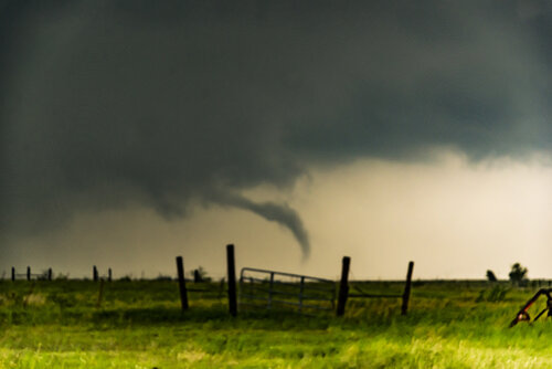
Tornado touches down near Paducah, Texas during the early to mid afternoon of May 20. The view is to the WSW.

m20tor19.jpg

Above: Thin rope stage of the Paducah, Texas tornado on May 20. The view is to the W.

m20tor20.jpg

Above: 
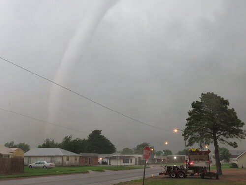
Close up view of the tornado near Paducah, Texas on May 20 showing the thin and hollow structure of the vortex tube.

18650

Above: 
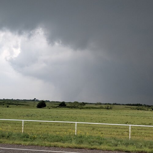
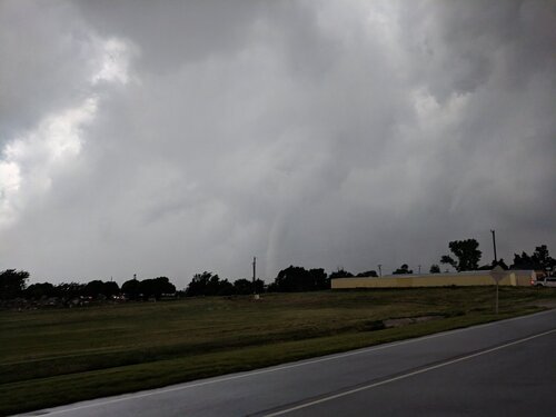
Storm cycling and producing another large funnel, or even a brief tornado, west of Childress, Texas on May 20. The view is to the SSE. This same storm will eventually produce another series of tornadoes, including the one near Mangum, Oklahoma.

m20nav1.jpg

Above: View of the navigation software and tracking showing how difficult it was to find a way back across the Red River. The original supercell can be considered "lost" at this point!
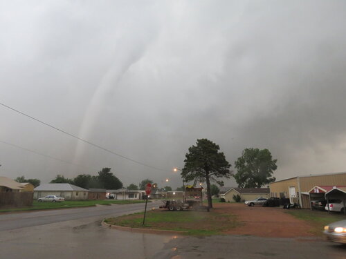
m20gf1.jpg

Above: The storms near Hollis, Oklahoma later in the day became an active squall line and messy MCS (instead of the feared cluster of violent tornadic supercells). This shelf cloud and strong outflow denotes the chase day of May 20 is pretty much over.

Note: For DETAILS on this storm / setup as well as others in May 2019 … Please visit the link BELOW for more information!

 
The most memorable thing about this day for me isn't how under performing the overall setup ended up being, but that I got my favorite personal pic of me and a tornado on this day (see avatar).

I was personally targeting Paducah this day. No real reason other than I believe Cottle County is quite a hot spot in general. There was a lot of great looking real estate the morning of, with my home in Amarillo being the starting point. Met up with some local chasers at the new Allsups in Clarendon (the have actual usable bathrooms) hyping each other up for the day. My plan was to pluck the storms down the dryline starting from about Paducah southward. First storms popped up on radar around 2:30, and we didn't waste much time headed for the storm. We approached from the north through a weak core. And shortly thereafter, we had our first tornado reaching down. We had a nice distant view of the snake like tornado all the way to rope out.

19276

And that was it. Our day was over just after 4pm. We continued north but decided against staying with the crowds north of the Red River. We began plucking the storms down the dryline, and drove from Childress to just east of Midland as night fell. But the storms never put on anything better than what we saw early on. We still counted the day a great success. Sadly, this might actually be the most photogenic tornado I've ever seen on a high risk.

 
Back
Top