• After witnessing the continued decrease of involvement in the SpotterNetwork staff in serving SN members with troubleshooting issues recently, I have unilaterally decided to terminate the relationship between SpotterNetwork's support and Stormtrack. I have witnessed multiple users unable to receive support weeks after initiating help threads on the forum. I find this lack of response from SpotterNetwork officials disappointing and a failure to hold up their end of the agreement that was made years ago, before I took over management of this site. In my opinion, having Stormtrack users sit and wait for so long to receive help on SpotterNetwork issues on the Stormtrack forums reflects poorly not only on SpotterNetwork, but on Stormtrack and (by association) me as well. Since the issue has not been satisfactorily addressed, I no longer wish for the Stormtrack forum to be associated with SpotterNetwork.

    I apologize to those who continue to have issues with the service and continue to see their issues left unaddressed. Please understand that the connection between ST and SN was put in place long before I had any say over it. But now that I am the "captain of this ship," it is within my right (nay, duty) to make adjustments as I see necessary. Ending this relationship is such an adjustment.

    For those who continue to need help, I recommend navigating a web browswer to SpotterNetwork's About page, and seeking the individuals listed on that page for all further inquiries about SpotterNetwork.

    From this moment forward, the SpotterNetwork sub-forum has been hidden/deleted and there will be no assurance that any SpotterNetwork issues brought up in any of Stormtrack's other sub-forums will be addressed. Do not rely on Stormtrack for help with SpotterNetwork issues.

    Sincerely, Jeff D.

2024-04-15 EVENT: NE/KS/OK

Gotta love the satellite feed being down. From COD:
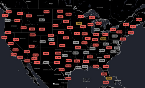
That's just the half of it. NWS radar network was down during the night with ~80% of the radars offline (some radars, like ICT's were down but were not shown).

The NWS is literally falling apart. We must have a Natural Disaster Review Board to advise NWS and the administration -- otherwise, things will only get worse.
 

Attachments

  • Screenshot 2024-04-15 at 9.59.49 AM.png
    Screenshot 2024-04-15 at 9.59.49 AM.png
    1.3 MB · Views: 5
Satsquatch.com also is pretty decent for satellite data and they have a working feed. The free Unidata AWIPS has been down all weekend, i believe for unrelated issues. I'd go one further and say our country is coming apart and we're watching the managed decline of the USA. I don't know how data outages on what I'd consider a decently weather critical day is going to help their mission of protecting life and property.
 
Is there going to be live thread for this event to switch to? Might be a good one to practice on.

Yes, @Jeff Duda and I will have a nowcasting event this evening on Zoom. This will be a pilot program to discuss this evening's severe weather event. We will begin at 4 PM MT/5 PM CT/ 6 PM ET. There will be a discussion of the synoptic and mesoscale features of the event, targets, etc. Everyone is welcome to join.

https://zoom.us/j/97977022252
 
The environment down along I-20 looks excellent. If a storm goes down there, it will be good. The cap is shown killing it after a couple of hours though. I can't make it down there in time anyway, and going down there is going to make getting back for Tuesday difficult.

It looks like the dryline in Kansas might stay west of the cloud deck. The OUN sounding shows better moisture depth upstream, and that's on the move northbound. Definitely better looking than last night, though it does appear the show will be entirely after dark.
 
I suggest we just go ahead and make this a NOW thread?

SPC just issued a MSD for the Childress area south, quite a ways. At some distance south, I'm assuming you start losing favorable upper level shear.
 
I still think a couple supercells are going to blow up in SW KS and some of the CAMs are hinting at it as well. As referenced before the models last time I checked (outside working right now) showed a good environment in the SW KS region. For better or worse I had picked Great Bend, but couldn't make it happen today although if I left now I could still be in position before convection initiates.
 
Is there going to be live thread for this event to switch to? Might be a good one to practice on.
See Jeff's post at the end of this thread:

 
The environment down along I-20 looks excellent. If a storm goes down there, it will be good. The cap is shown killing it after a couple of hours though. I can't make it down there in time anyway, and going down there is going to make getting back for Tuesday difficult.

It looks like the dryline in Kansas might stay west of the cloud deck. The OUN sounding shows better moisture depth upstream, and that's on the move northbound. Definitely better looking than last night, though it does appear the show will be entirely after dark.

Sweetwater has a less-than-optimal T/Td depression though... Towards Abilene is much better, but east of there the road network and terrain are tough to navigate... I dislike that whole area southeast of Rotan...

Not much convergence on the SW KS portion of the dryline - I think the models handled that fairly well. Maybe a better shot when the dryline retreats later...

CDS looks like a great spot right now as Warren has been saying, but it's still cloud-covered...

NAM3km much more aggressive w/ convection than HRRR, which only has an impressive cell further south in TX.
 
Back
Top