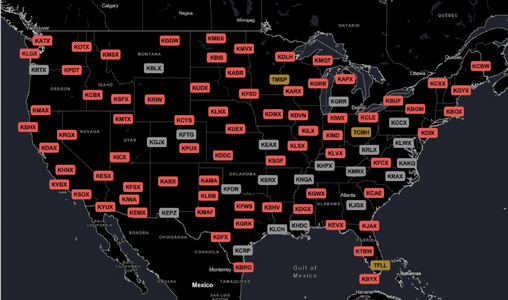
2024-04-15 EVENT: NE/KS/OK

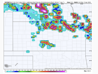
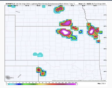
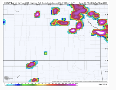
As I know some people do not have access to this, here are the 18Z ECMWF's lightning forecasts from 5pm Monday to 11pm at 2-hour intervals.

The storm that develops near Pratt at 5p moves NNE and intensifies until it hits the warm front two hours later.

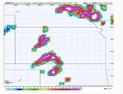
The dry line finally begins erupting around 9 and is going full blast at 11 with two possible cells ahead of the line.

Just in: the new Nadocast is quite interesting:
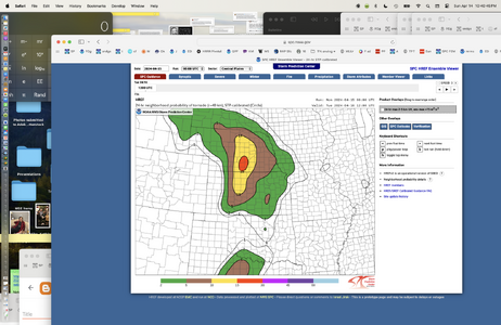
Finally, here is the new (10:40pm HREF from SPC, at far right).
 

Attachments

  • Screenshot 2024-04-14 at 10.22.35 PM.png
    Screenshot 2024-04-14 at 10.22.35 PM.png
    823.9 KB · Views: 13
  • Screenshot 2024-04-14 at 10.22.47 PM.png
    Screenshot 2024-04-14 at 10.22.47 PM.png
    537.3 KB · Views: 12
  • Screenshot 2024-04-14 at 10.22.58 PM.png
    Screenshot 2024-04-14 at 10.22.58 PM.png
    593.8 KB · Views: 10
  • Screenshot 2024-04-14 at 10.23.06 PM.png
    Screenshot 2024-04-14 at 10.23.06 PM.png
    664.8 KB · Views: 12
  • Screenshot 2024-04-14 at 10.40.45 PM.png
    Screenshot 2024-04-14 at 10.40.45 PM.png
    992.6 KB · Views: 35
To me, this setup has some shades of 4 May 2007 (Arnett/Greensburg) and 17 May 2019 (Forgan/Minneola) for the S Plains portion of each setup. But that doesn't mean it will have an outcome worthy of its own town names.

CAMs have not been very excited thus far about robust CI along the dryline, at least outside the deeply mixed air near I-20 in TX. However, there are some hints of CI in coarser guidance like the ECMWF, ICON, and even GFS... particularly during the 00z-03z timeframe.

Although the incoming wave timing is certainly later than "ideal," there are substantial mid-level height falls forecast even before 00z, with a strong upper jet punching into the OK Panhandle vicinity.

With all that being said: it's not like I'm sold on robust supercells before dark. It's 3-5 weeks earlier in the season than the two events I mentioned above, and moisture will be a bit inferior, as well. But if a subtle ripple in the upper flow, a dryline bulge, or whatever other factor manages to spark explosive convection during the early evening in the E Panhandles or SW KS, the tornado potential would obviously be considerable.

Ultimately, I think this is one of those textbook dryline gambles: even the best forecaster among us isn't going to know whether this is destined to be a cap bust; a significant, impactful event; or something in between until lunchtime or later. In my view, it's worth the gamble if you're within a few hours' drive of the W OK to C KS segment of the dryline, and it's one of those torturous high risk-high reward propositions if you're not.
 
I just now ran Col Miller's 14 point checklist for tornadoes using 18Z ECMWF. Each parameter is rated either weak/medium/strong.

All of the first five (most important) are strong. #6, 850mb moisture is moderate. #7 to 14, are all strong except for one which is unknown because, to my knowledge, the map needed to assess it is no longer produced.

More and more, I'm thinking we are looking at a big day tomorrow in Kansas and, maybe, southern Nebraska. Oklahoma ahead of the dry line is more uncertain and, yes, I agree with Warren there will be a tail-end event in the SPS-CDS region.

The question is timing. Both of the events Brett mentioned (above) were after sunset. However, the ECMWF (see my posting above Brett's) has storms firing by 5pm.
 
Typically if I were to chase this set-up I would have left today by early afternoon to hotel in either OK or KS depending on the favored target. Based on model data earlier today I couldn’t justify the long trip out, yes the potential is there but the odds of a bust are too large. I’ll be sitting Monday out but if chasing I would target SW OK/NW TX where the parameters are off the charts and some CAMs initiate convection prior to 00z. But overall the risk/reward to me isn’t worth it, especially when Tuesday has potential much closer to home that would require a marathon chase from either the KS or OK location. I’ve done that before and barely made it in time for the 4/9/15 Rochelle-Fairdale EF-4 after driving 650+ miles from Wichita after busting the day before…and that day had less of a bust risk than 4/15/24. Kind of funny that my first Illinois tornado was less than 40 miles from home but I had to drive over 650 miles to see it...that’s the nature of chasing sometimes but not this time. Sitting Monday out and hoping that Tuesday presents an opportunity much closer to home.

Edit: If I lived in TX/OK/KS this would definitely be a chase, this is the type of set-up where I envy the southern plains based chasers!
 
Last edited:
To me, this setup has some shades of 4 May 2007 (Arnett/Greensburg) and 17 May 2019 (Forgan/Minneola) for the S Plains portion of each setup.

I believe both of these events were pretty heavily reliant on the evapotranspiration from the winter wheat crop. Being later in the season would make things better in that regard.

I know the moisture isn't "great" (or is it?) but the 00Z OUN had a MeanW of 12.1. That's been pretty adequate I have found. Fort Worth a full 13.0. Have you been outside this evening? It does have that humid feeling. It snuck in during the day today.

The models do indeed look kinda like garbage tonight for tomorrow, but as Mike pointed out we're checking off a lot of boxes.
 
DDC AFD notes “pristine supercell environment” but “very low” confidence that a storm will develop before 0Z to take advantage of it.

However, this NAM forecast sounding (near Larned, northeast of DDC) shows little cap by 0Z. The NAM 3K is similar. Perhaps the bigger issue is lack of convergence along the dryline, which DDC also notes. In fact most models look worse than the NAM, showing a dryline that is not sharp in KS and/or mixes further east by 0Z. See Euro below for example.

IMG_2099.png


IMG_2100.jpeg
 
While all the ingredients look to be in place and the cap doesn't look to be impenetrable I'm noticing the dryline retreating in W OK/S KS and doesn't make a push east until well after dark so forcing may be a big issue today further north. Really don't want to go down to the Seymore area again but that may be where it's at today.
 

Attachments

  • floop-hrrr-2024041511.sfctd-imp.us_c.gif
    floop-hrrr-2024041511.sfctd-imp.us_c.gif
    1.7 MB · Views: 7
I believe both of these events were pretty heavily reliant on the evapotranspiration from the winter wheat crop. Being later in the season would make things better in that regard.

I know the moisture isn't "great" (or is it?) but the 00Z OUN had a MeanW of 12.1. That's been pretty adequate I have found. Fort Worth a full 13.0. Have you been outside this evening? It does have that humid feeling. It snuck in during the day today.

The models do indeed look kinda like garbage tonight for tomorrow, but as Mike pointed out we're checking off a lot of boxes.
That is a great point about ET. I was thinking yesterday about how both those events were also in wet springs where we were coming out of a wintertime Nino and the subtropical jet was active. But the difference is that the Panhandles and W KS were green and lush, which we still don't have right now.

And all else being equal, it is unfortunate that last week's soaker was confined to mainly S of I-40, leaving the most interesting synoptic target today in short-term drought.

While all the ingredients look to be in place and the cap doesn't look to be impenetrable I'm noticing the dryline retreating in W OK/S KS and doesn't make a push east until well after dark so forcing may be a big issue today further north. Really don't want to go down to the Seymore area again but that may be where it's at today.
One interesting thing about the two events I mentioned (2007-05-04 and 2019-05-17) is that, at the synoptic scale, the dryline was either stationary or retreating through the early evening. There may have been mesoscale perturbations where it advanced or buckled over a focused area, though. Sometimes, these events with a surface low in KS/NE and a long, sharp dryline that's fairly stationary can pop an isolated storm or two that goes nuts. But yeah, the I-20 corridor looks like maybe the greatest odds of convection overall.

As the sun comes up, my biggest concern for today is shifting toward cloud cover, which SPC correctly highlighted in their initial SWODY1. If we can't get most of that out of the picture along the dryline by mid-afternoon, my hopes will dwindle considerably.
 
If I was there....... I'd be in Amarillo drinking my morning coffee and looking over data before heading SE. The words "retreating dryline" is always grounds for "red alert." I'm still sold on staging in Childress, TX and adjusting my location as the day progresses. RH in this region is better and surface heating might be unhindered. The +6 hour SPC supercell composite (below) and multiple CAMs suggest favorable parameters and some type of development before 00z. I believe this **may** be the only chance of seeing something before dark. After dark, all bets are off. As others have said, this is a classic set-up for nighttime monsters, like Greensburg. Chasers will need to be careful if pursuing cells after dark.

sell.png
 
If I was there....... I'd be in Amarillo drinking my morning coffee and looking over data before heading SE. The words "retreating dryline" is always grounds for "red alert." I'm still sold on staging in Childress, TX and adjusting my location as the day progresses. RH in this region is better and surface heating might be unhindered. The +6 hour SPC supercell composite (below) and multiple CAMs suggest favorable parameters and some type of development before 00z. I believe this **may** be the only chance of seeing something before dark. After dark, all bets are off. As others have said, this is a classic set-up for nighttime monsters, like Greensburg. Chasers will need to be careful if pursuing cells after dark.

View attachment 24872

Hoisington 2001 also comes to mind. That was also in mid-April before greenup was really there to help with moisture ET.
 
The RAP is zeroing in on that area near Childress as well, then exploding the state line area up US83.

Gotta love the satellite feed being down. From COD:
Update (4/15/2024 2:20:43 PM): The primary National Weather Service satellite image feed is down. Those who have ground stations picking up the feed directly instead of going through the NWS are not affected. We do not have an estimated time of return, but this means all NWS forecast offices also have NO satellite imagery either. -Gilbert
 
Back
Top