• A friendly and periodic reminder of the rules we use for fostering high SNR and quality conversation and interaction at Stormtrack: Forum rules

    P.S. - Nothing specific happened to prompt this message! No one is in trouble, there are no flame wars in effect, nor any inappropriate conversation ongoing. This is being posted sitewide as a casual refresher.

2024-04-15 EVENT: NE/KS/OK

Joined
Feb 19, 2021
Messages
531
Location
Wichita
I'm shocked no one has begun a thread on what looks like an outbreak day on Monday, Tax Day.

I'm sure everyone has seen SPC's forecasts, so no need to recount them.

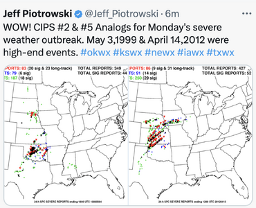
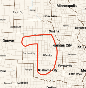
We'll kick this off with my friend Jeff Piotrowski's find of the two best analogs which -- if either verifies -- are frightening. Of course, the only city to be hit both of those days was Wichita, which might be a good preliminary target for Monday.

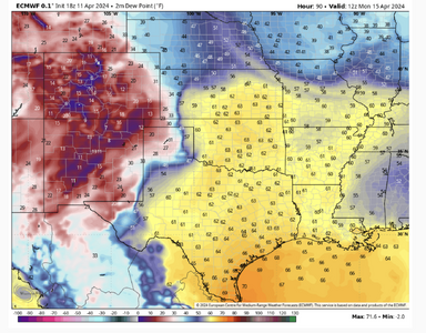
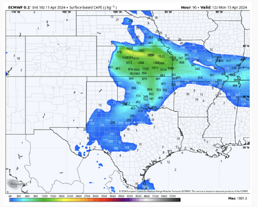
The ECMWF shows plenty of instability plus a negatively tilted trough. The various models have High Plains surface pressure as low as 884mb which is extremely low any time of year but as late as mid-April? Wow.

It is far too soon to get into the intricacies because they are unforecastable at this point. I've already cleared my calendar for Monday.

Some suggestions for new chasers:
  • Other factors roughly equal, Kansas has better roads than Oklahoma and more consistent roads than Nebraska (too many roads end at creeks in that state). West of the Flint Hills, Kansas is very flat except for the south central Gyp Hills (esp.Barber Co.) and the Jerusalem Rocks of NW Kansas.
  • There is such as thing as "too dangerous to chase," especially for beginners. If we get high-end moisture the visibility may go down in haze, especially with annual agricultural burning in progress. These storms may have forward motions of 40-50mph (too soon to know for sure) and it is essential to be able to see to keep yourself out of danger.
  • Especially if you are inexperienced, don't chase alone on a day like this is forecast to be. It is completely unsafe to be driving and trying to watch radar and other data. Your life is never work risking.
 

Attachments

  • Screenshot 2024-04-11 at 4.07.27 PM.png
    Screenshot 2024-04-11 at 4.07.27 PM.png
    598.5 KB · Views: 65
I may actually fly out for this one -- depending on future model runs. There is a lot of excess chatter right now, bordering on hype, especially this far out. I suppose it's mostly caused by the number of big busts, so everyone is overly antsy for a good chase day. A lot will depend on how far the DL races east. I've seen similar dynamic set-ups push the sweet spot into the Mekong Delta east of I-35 which is the no go line for me, especially with storms moving at 50+ mph as forecast. I would not rule out a target in the CDS area.
 
Yes, east of I-35 in KS is good, but not in OK. Just priced out this chase and it's not in my budget. Air fares are insane now days. An out of state chaser could easily drop 2k on just airfare and a rental car. :mad:
 
For years I’ve been telling myself I don’t have to just settle for a lousy two week chase vacation and could always head out for a single day, synoptically evident, high end event forecast enough in advance. Some far less experienced chasers than me have done this and scored more big events than me, even without taking lengthy chase vacations. It never seems to work out for me to actually do it. Weather, work and life always seem to conflict. And quite frankly it can be a pain in the ass to get out and back for a single day event; it’s hard to get motivated to wager so much time and money, especially on short notice.

But this time, I am about 85% certain I am finally going to do it. Monday looks like a slam dunk so far. I can travel out on Sunday without worrying about missing work time to travel, hopefully get some work done Monday morning, chase Monday afternoon and evening, work remotely on Tuesday and fly home Tuesday night.

Biggest consideration for me is how far west the dryline sets up. I plan to fly into Dallas, as it’s the only place I can fly direct. I don’t want to drive late on Sunday night, and I don’t want to have to take the entire day off Monday because of a long positioning drive. Achikdress target would be ideal. But I am committed to finding a way to make it work.

I’ll post some forecast thoughts tomorrow or Saturday. I’ll start making travel plans after the Friday 12Z models come out.
 
An out of state chaser could easily drop 2k on just airfare and a rental car. :mad:
Have you looked at flying into ICT? If I recall, you fly out of PHX. A RT, non-stop, from PHX to ICT Saturday evening and returning Wednesday (thinking you may wish to chase Tuesday) is $545.
 

Attachments

  • Screenshot 2024-04-11 at 7.24.25 PM.png
    Screenshot 2024-04-11 at 7.24.25 PM.png
    300.8 KB · Views: 35
Jim,

I don't mean to be everyone's travel agent, but if you are willing to fly to ICT (now looking like a reasonable target area) from PHL, here are some fares on SWA. These are round trips. Leave Sat, return Wed.
 

Attachments

  • Screenshot 2024-04-11 at 7.33.24 PM.png
    Screenshot 2024-04-11 at 7.33.24 PM.png
    375.3 KB · Views: 33
Thanks for checking... Yes, looked at that but ICT is too far N. for me ATM and I'm in Tucson. Plus, cannot leave until Sunday. Getting off topic, but appreciated. I'll have more time to check things out tomorrow.
 
For years I’ve been telling myself I don’t have to just settle for a lousy two week chase vacation and could always head out for a single day, synoptically evident, high end event forecast enough in advance. Some far less experienced chasers than me have done this and scored more big events than me, even without taking lengthy chase vacations. It never seems to work out for me to actually do it. Weather, work and life always seem to conflict. And quite frankly it can be a pain in the ass to get out and back for a single day event; it’s hard to get motivated to wager so much time and money, especially on short notice.

But this time, I am about 85% certain I am finally going to do it. Monday looks like a slam dunk so far. I can travel out on Sunday without worrying about missing work time to travel, hopefully get some work done Monday morning, chase Monday afternoon and evening, work remotely on Tuesday and fly home Tuesday night.

Biggest consideration for me is how far west the dryline sets up. I plan to fly into Dallas, as it’s the only place I can fly direct. I don’t want to drive late on Sunday night, and I don’t want to have to take the entire day off Monday because of a long positioning drive. Achikdress target would be ideal. But I am committed to finding a way to make it work.

I’ll post some forecast thoughts tomorrow or Saturday. I’ll start making travel plans after the Friday 12Z models come out.

I'd really pay close attention to the forecast. They will be very fast moving storms and there are still a lot of questions to be resolved. The long-range forecasts this year have been a problem and the inertia from this event is off the scale ATM.
 
So we have been missing something recently in OK, we have been close but it just never reaches the potential. But I will say this IF it goes up and is memorable we will be saying remember the Tax Day Outbreak right after the Eclipse. LOL
 
Things of which I am confident:

For those that do not have access to the 18Z ECMWF, here are the forecast dew points for 7am Monday (as far out as the off-hour deterministic goes).

At 500mb the 18Z is a bit faster and farther north as compared to the 12Z run . Heights across Kansas and southern Nebraska (and NW OK to a lesser extent) crash during the day Monday. It will be fast-moving system due to being "kicked" by an impulse over the State of Washington. I've found that fast moving systems produce supercells more readily than slow-moving systems, other factors equal.


Things of which I am not confident:

This is the first time for Kansas in ≥ two years where moisture and instability look abundant. At 12Z (from 18Z run today) Monday, we already have 1,900j of surface-based CAPE. See middle map.

I have attached my "first guess" as to where tornadoes may be Monday based on the 12Z and 18Z ECMWF's. If I had to pick a starting point to chase, it would be somewhere Alva to Medicine Lodge. I don't have a lot of confidence in the tornado forecast outline below, but it is "first guess." The forecast 500mb pattern is surprisingly similar to April 26, 1991 (Wichita-Andover, Red Rock, etc.) as I still have the charts. In 2024, the strongest PVA is into Kansas with surface pressures falling roughly 16mb (!!) in the 12 hr. ending at 7pm in the western part of the state and 8-10mb in central Kansas. I've always found significant falling pressures and heights are part of any major tornado situation.


A bit of history, on 4/26/91 the temperature was 81° and the dew point 69° at McConnell at 6p, the tornado got there about 20 minutes later. Monday is looking like 78-79F and Td ~ 66°.

So, while this is very preliminary, it is my first guess for what it is worth.
 

Attachments

  • Screenshot 2024-04-11 at 9.14.01 PM.png
    Screenshot 2024-04-11 at 9.14.01 PM.png
    1.6 MB · Views: 39
  • Screenshot 2024-04-11 at 9.31.23 PM.png
    Screenshot 2024-04-11 at 9.31.23 PM.png
    1 MB · Views: 33
  • Screenshot 2024-04-11 at 9.48.17 PM.png
    Screenshot 2024-04-11 at 9.48.17 PM.png
    713.5 KB · Views: 44
It would appear that heavy cloud cover on Monday could be an inhibiting issue as we have seen with multiple set-ups this year. I would suspect that large scale forcing would be more than adequate to overcome it. The question now becomes timing and how far the DL pushes east before forcing gets the show going. I'm going to wait until Saturday and view the higher resolution models before making any deployment decisions.

I have little doubt there will be severe weather events, but the questions of when and where need to be determined.
 
Just getting back into my normal routine after the eclipse trip, otherwise I'd have posted earlier. The NAM and the Euro agree on the forcing arriving in time. The NAM depicts a relatively narrow warm sector with the cap eroding right on the dryline at 00z, but by no means does that look like a problem for the setup. I'm in agreement with what's been said so far that the synoptics look like a no-brainer chase day, just a question of where. I'm at James' level of confidence on a trip, that will only increase if models remain in agreement on what's been shown so far. I already put in for PTO on Monday.
 
Well my enthusiasm for this event had a short half-life. If I was out there of course it would be a “chase day.” But I no longer think it’s worth the time, money or effort to fly out from Philadelphia just for this. There are too many limiting factors -

- Timing of initiation before dark. Keep in mind we have ~30 minutes less daylight compared to late May. (30 minutes of daylight is significant, considering how many storms even in late May don’t really get cranking until a couple hours before dark).
- Depending on the model and particular segment of the dryline, there are areas of strong mixing (veered winds to the east of the dryline and lack of a sharp moisture gradient), areas where the dryline is sharper but convergence not great, areas where it’s more of a Pacific front than a dryline (not very hot in the drier air) or the Pacific front is overtaking the dryline.
- Cap may be too strong and/or instability too weak given cloud cover in the warm sector (also influences timing above)
- No precip at 0Z shown on NAM or Euro. GFS does show convection at 0Z (but not at 21Z). NAM 3KM not out that far yet.
- Quality and depth of moisture (noted as a potential issue in SPC Day 3 and in AMA AFD)
- Further west dryline position makes it a little more logistically difficult for me, trying to take a relatively quick trip to limit travel time and lost work time, with a nonstop flight which limits me to flying into DFW and leaves more driving than I was hoping for (wanted to get to DFW Sunday night and work half day Monday)

SPC is backing off on the earlier strong language. Now it’s “scattered thunderstorms” and “a few tornadic storms are possible.” Understanding that there is some inertia to maintain continuity with earlier forecasts, read between the lines and they are probably even less bullish on the event than they are actually saying.

It really is quite expensive and disruptive to do a one day chase from the east coast, so in some ways I am biased toward finding reasons not to chase. I certainly would go for it if I were already on my chase vacation, or if I had no other responsibilities or commitments, and I wouldn’t discourage anyone from chasing Monday. But it’s no longer the slam dunk it appeared. I guess this will be another year of me saying I’m going to be more aggressive about going out when opportunities present themselves and then not doing it…
 
Last edited:
Wise decisions by everyone. If I lived within a few hundred miles, I would go for it, but a long drive or flight from Tucson is not justified. As a long-shot chaser, I might focus a little further south, maybe CDS or even further south / southwest and hope for a cap-cracking, Panahdle magic event near the dryline right before sunset.

Interestingly, the GFS had wonky hodographs for days, not worthy of a "major" event. I figured this would change as the trough approached, but it never did.

There is still plenty of time for things to change. I've seen seesaw patterns like this actully contribute to a bigger day than expected. I believe there will be at least one isolated event, or multiple events after dark.
 
I've taken today's base SPC forecast and modified it a bit: Keep an Eye on the Weather Monday

I can't see that much has changed since Thursday. This morning's FV3 looks almost exactly as I'd pictured it except the storms are just a bit farther southeast ( ~50 mi or so) than I expected.

At 7p Monday, the 3km NAM is showing thunderstorms just starting to fire. At the same time, here are the forecast STP's (middle).

In 2024, the CAMs have generally underforecast moisture but is forecast to be saturated, or nearly so, to 850mb on both the 3kmNAM and FV3 at 00Z along the dry line. Here is the Alva OK 7pm forecast sounding.
 

Attachments

  • Screenshot 2024-04-13 at 10.19.52 AM.png
    Screenshot 2024-04-13 at 10.19.52 AM.png
    902.7 KB · Views: 22
  • Screenshot 2024-04-13 at 10.11.54 AM.png
    Screenshot 2024-04-13 at 10.11.54 AM.png
    778 KB · Views: 25
  • Screenshot 2024-04-13 at 10.07.08 AM.png
    Screenshot 2024-04-13 at 10.07.08 AM.png
    507.7 KB · Views: 26
Can't say I'm real encouraged by SPC mentioning initiation after 0z and widespread convection thereafter. Waiting for most of the CAMs to come into range but FV3 is bullish on convection prior to dark, but 3KNAM not so much. One thing I've noticed over the last two seasons is that HRRR tends to be a couple of hours late vs actual initiation so if it doesn't fire storms until 01z it's a fair bet that there will be initiation around 23z.

I'm not much of an night-time chaser so the amount of daylight is important to me. Thankfully, the chances of my target being within two hours drive are pretty good so I'll be out regardless.
 
For those who don't know me, I'm an "old-guy" meteorologist who began forecasting tornadoes in the late 1960's when there were -- gasp -- no models at all 🙂. I find that experience very useful as a check for when the models' forecasts look wonky. So, I thought I'd pass along some old time info on the upcoming situation.

The father of severe storms forecasting, the late Col. Bob Miller of the USAF, swore by the SWEAT index which is a really useful product because it combines instability and shear. SWEAT also assumes the moisture reaches 850mb, so it is implicitly saying moisture depth will not have a problem. It predates hodographs by decades. The SWEAT tornado threshold is 500. Below are forecasts from the Saturday 12Z ECMWF (via AccuWeather's model site) and are very high values. Keep in mind Kansas' worst tornadoes (Udall, Greensburg, Ruskin Heights, Topeka, Hesston/Moundridge) were all at or after sunset with the exception of the latter which was afternoon. When the SWEAT is 700+ in a highly dynamic atmosphere (strong PVA plus pressures fall 11mb at DDC in 12hr ending at 7p), a major threat exists.

Miller also had an objective forecast list. Of the first five on his list (in order of importance), all five are "strong" for Monday and, of the next five, all are strong or "moderate."

I agree that this may later in the day than we would like from a chasing/photography point of view. But, from a danger to the public point of view, this could be a bad day. The ECMWF has these 1-hr lightning forecast maps ending at 7p and 11p (WeatherBell). The supercells become more widespread after 11p.

Finally, there is some chance of a warm front play near or north of I-70 in Kansas.
 

Attachments

  • Screenshot 2024-04-13 at 1.15.21 PM.png
    Screenshot 2024-04-13 at 1.15.21 PM.png
    1.4 MB · Views: 20
  • Screenshot 2024-04-13 at 1.15.39 PM.png
    Screenshot 2024-04-13 at 1.15.39 PM.png
    1.3 MB · Views: 17
  • Screenshot 2024-04-13 at 1.45.10 PM.png
    Screenshot 2024-04-13 at 1.45.10 PM.png
    654.1 KB · Views: 16
  • Screenshot 2024-04-13 at 1.45.32 PM.png
    Screenshot 2024-04-13 at 1.45.32 PM.png
    691.2 KB · Views: 19
Agree with the above that Monday is no longer a "drop everything and fly in from halfway cross the country to chase" (if it ever was) type of setup, but is a definite chase if you're local/regional with a high public hazard potential type of setup.

Monday is out of range for me due to work but I plan to chase Tuesday afternoon (have Wednesday morning off, 3AM-noon shift), most likely in Iowa assuming it continues to look at least as good as it does on today's 12Z NAM.

For Monday, the preferred spot could be in south-central Kansas where the 3K NAM appears to portray a dryline bulge with the environment in the attached forecast sounding out ahead of it, but as others have noted, the model has not fired robust supercells in this environment by 0Z Tuesday. However, despite -7 MLCINH, the lack of an apparent warm nose (rightward jog in the temperature profile) on the skew-T suggests to me (someone better versed in thermodynamics and how CINH numbers actually relate to temperatures at certain heights, correct me if I'm wrong) initiation should be commencing shortly if not underway.

As an aside, I threw this together for s***s and giggles and to get pumped for chase season '24 using the music video for Van Halen's "Humans Being" from the Twister soundtrack and my storm footage over the years. Enjoy and here's to successful and safe chasing on Monday/Tuesday!


Attachments

  • nam4km_2024041312_060_37.16--99.3.png
    nam4km_2024041312_060_37.16--99.3.png
    244.1 KB · Views: 17
I've taken today's base SPC forecast and modified it a bit: Keep an Eye on the Weather Monday

I can't see that much has changed since Thursday. This morning's FV3 looks almost exactly as I'd pictured it except the storms are just a bit farther southeast ( ~50 mi or so) than I expected.

At 7p Monday, the 3km NAM is showing thunderstorms just starting to fire. At the same time, here are the forecast STP's (middle).

In 2024, the CAMs have generally underforecast moisture but is forecast to be saturated, or nearly so, to 850mb on both the 3kmNAM and FV3 at 00Z along the dry line. Here is the Alva OK 7pm forecast sounding.

Mike----One correction, although trivial, Is the 1966 Topeka tornado went all the way through town with the sun up. It occurred roughly from 7:00 to 7:30 on June 8.
 
For what it is worth, sunset at Dodge City Monday is 8:16pm. So, the light should be decent until about 8:30.

True, but in this situation where it would be an out and back trip for me from the east coast, it’s just not worth it for at most 90 minutes of action before dark. And that’s more likely to be the ceiling than the floor.
 
The late timing, models not reliably convecting before sunset (if at all) and the shallow moisture are all things that make me feel the need to back off of chasing this. I think the first two of those could be overlooked if not for the third. We've seen plenty of events like this where storms actually did fire by late evening, and I would not be surprised if one or two did. Some models do have the left exit region of the jet over the dryline at 00z, even if they don't convect. The moisture issue is what I don't think this system can realistically overcome to produce much of any quality.

The late timing also puts into question my ability to get home for Tuesday with adequate rest. A two-day grind is doable with a late enough sleep into Monday, but those usually aren't very fun. I'll be packed and ready to leave tomorrow, but will hold that decision off until the last possible minute.
 
Back
Top