Brett Roberts
EF5
In the spirit of recent threads decrying social media stealing real-time discussion from ST, I'm making an effort to post thoughts on some Plains days of interest this year... we'll see how long that lasts!
A major trough ejection out of the Rockies is on tap for Sun 2024-03-24. Across the N Hemisphere we see a relatively high wavenumber pattern, which typically isn't ideal early in the spring when moisture is scarce. Still, NWP progs for Sunday show a very impressive trough resulting from some degree of phasing between the polar and subtropical jets over the SW US during the prior 24-48 h.
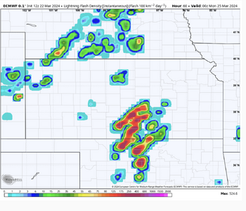
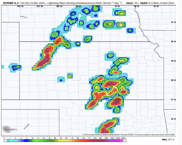
With a seasonably strong jet aloft punching into TX/OK, the dryline should be arced nicely SE-NW back toward a very deep sfc low (985 mb range) in W KS by 00z Mon. Dynamics and kinematics appear excellent for high-end severe weather. Moisture, of course, is the limiting factor... and with progged dews ranging from mid-upper 40s in W KS to low-mid 50s near the Red River, that limitation will be significant. It's common to hear chasers say "if only it were May" this time of year when 80-kt flow aloft and 40-kt LLJs are easy to come by. Sometimes that's just silly, but in this case it does sting... because it's not like we just had a Gulf-wiping front recently. We've had a relatively quiet, warm period this week leading up to the event, with mid 60s dews already sitting on the TX Gulf coast. If only the downstream wave weren't amplifying significantly this weekend over the SE US, we could probably manage enough moisture for respectable tornado potential. But, as it stands, we will be dealing with marginal moisture even relative to the seasonably cool temperatures aloft.
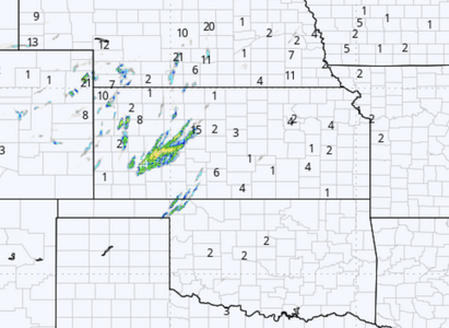
MLCAPE by late afternoon appears likely to range from 500-1000 J/kg along the most unstable segments of dryline, quite low by Plains chaseability standards. The marginal instability and moisture coupled with large, looping hodographs scream "structure chase" to me. The good news is that strong forcing should eject into the warm sector during the afternoon, so daytime convection is all but certain, barring an anomalously significant slowing trend for the lead times we're now at. IMO, the probability of supercells with decent to good structure by sunset is considerable. The Hollis, OK, supercell on 2019-04-03 is a good example of dynamic early season setups with similarly sad moisture coming through in that regard.
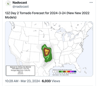
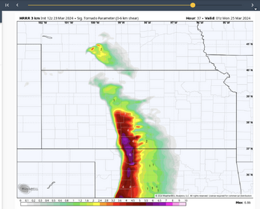
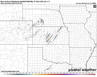
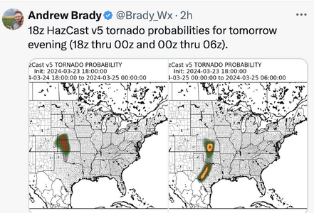
I would not rule out a low-end tornado threat around sunset, simply because this system is so dynamic and 500-mb temperatures as cool as -22 C are progged to punch over the dryline. But in general, this looks like a setup worth considering for structure fanatics and/or people within a few hours' drive... not so much tornado snobs. As of now, you could argue for anywhere from SW KS (best dynamics and cold punch aloft) to NW TX/SW OK (least objectionable PBL moisture). My hunch is that northern areas will be the better long-shot tornado target, whereas the safer structure/hail target will become clearer as CAMs come into range.
A final note is that when moisture looks this marginal and it's only March, would-be setups have been known to fall off a cliff even at these 3-5 day lead times... simply because moisture return that's 3-5 F worse than now progged, or entrenched cold air further constricting the warm sector, turns this into a complete non-event. The very high-end dynamics and vigorous return flow on Sunday should make that unlikely, but it's worth noting.
A major trough ejection out of the Rockies is on tap for Sun 2024-03-24. Across the N Hemisphere we see a relatively high wavenumber pattern, which typically isn't ideal early in the spring when moisture is scarce. Still, NWP progs for Sunday show a very impressive trough resulting from some degree of phasing between the polar and subtropical jets over the SW US during the prior 24-48 h.
With a seasonably strong jet aloft punching into TX/OK, the dryline should be arced nicely SE-NW back toward a very deep sfc low (985 mb range) in W KS by 00z Mon. Dynamics and kinematics appear excellent for high-end severe weather. Moisture, of course, is the limiting factor... and with progged dews ranging from mid-upper 40s in W KS to low-mid 50s near the Red River, that limitation will be significant. It's common to hear chasers say "if only it were May" this time of year when 80-kt flow aloft and 40-kt LLJs are easy to come by. Sometimes that's just silly, but in this case it does sting... because it's not like we just had a Gulf-wiping front recently. We've had a relatively quiet, warm period this week leading up to the event, with mid 60s dews already sitting on the TX Gulf coast. If only the downstream wave weren't amplifying significantly this weekend over the SE US, we could probably manage enough moisture for respectable tornado potential. But, as it stands, we will be dealing with marginal moisture even relative to the seasonably cool temperatures aloft.
MLCAPE by late afternoon appears likely to range from 500-1000 J/kg along the most unstable segments of dryline, quite low by Plains chaseability standards. The marginal instability and moisture coupled with large, looping hodographs scream "structure chase" to me. The good news is that strong forcing should eject into the warm sector during the afternoon, so daytime convection is all but certain, barring an anomalously significant slowing trend for the lead times we're now at. IMO, the probability of supercells with decent to good structure by sunset is considerable. The Hollis, OK, supercell on 2019-04-03 is a good example of dynamic early season setups with similarly sad moisture coming through in that regard.
I would not rule out a low-end tornado threat around sunset, simply because this system is so dynamic and 500-mb temperatures as cool as -22 C are progged to punch over the dryline. But in general, this looks like a setup worth considering for structure fanatics and/or people within a few hours' drive... not so much tornado snobs. As of now, you could argue for anywhere from SW KS (best dynamics and cold punch aloft) to NW TX/SW OK (least objectionable PBL moisture). My hunch is that northern areas will be the better long-shot tornado target, whereas the safer structure/hail target will become clearer as CAMs come into range.
A final note is that when moisture looks this marginal and it's only March, would-be setups have been known to fall off a cliff even at these 3-5 day lead times... simply because moisture return that's 3-5 F worse than now progged, or entrenched cold air further constricting the warm sector, turns this into a complete non-event. The very high-end dynamics and vigorous return flow on Sunday should make that unlikely, but it's worth noting.