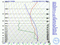
Completely separate discussion: just looked at the 00Z UCAR ensemble. Seems to be some sizeable uncertainty unless things have dramatically changed since that forecast cycle. The ensemble says storms will likely initiate in far W TX shortly after 18Z. By 00Z they will only just be approaching the OK-TX border, but will already be a squall line. Interesting.
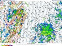
I had typed up a post on Monday morning before heading out worried about the difference between the HRRR and 4 km NAM solutions. The 12Z 4 km NAM had depicted the boundary would only just be approaching AMA at 00Z with storms only that far east. I was not excited about the prospect of having to go that far west, especially given how suddenly progs had changed over the past few days. However, my previous post above alluded to the change in forecast. As it turns out, this forecast of lagged ejection of the trough and associated boundaries verified, as evinced by the following mesoanalysis of surface divergence and winds:

The main boundary was, in fact, west of Amarillo at 00Z. I had been banking on some sort of pre-frontal convergence to fire off storms. This did happen, and I was right on that convergence when it happened (we sat looking at CU towers near Groom at 4 PM).
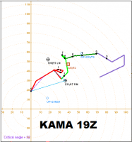
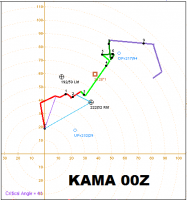
I have only myself to blame for my bad chase experience. There are many things I should have done differently. For one, I shouldn't have gone all the way through Palo Duro Canyon to intercept the first storm. I wasn't paying close attention to radar, plus data was intermittent anyway. I had visual of it, but my view of the base was shrouded by the heavy precip. I had assumed the storm would turn to the right eventually, so I was more worried about getting south ahead of the core. As seen by comparing the 19Z and 00Z AMA soundings, the hodograph tilted counterclockwise during the late afternoon, pulling the right-moving storm motion vector to the left. It seemed to me the whole day that storm motions had too little eastward component. I guess the motions do look fairly consistent with the 00Z hodograph.


Second, I just plain shouldn't have given up after last light. After taking a closer look at the images I shot near Goodnight of the first storm passing off to the north, I can pretty clearly discern a horseshoe shaped cloud base. There was even a darker mass embedded within the left edge of it (relative to my view), which would be the correct storm relative location for tornadoes. Even on the second storm, my last few shots showed a clear slot being punched by an RFD. However, the storm had formed several shallow lowerings below the base that all fizzled within minutes.
Third, I should've kept a closer eye on the data. Given the westward position of the storms, I was assuming they were struggling during daylight hours because they didn't have that better moisture that was in place in far W OK. Dewpoints in the eastern TX PH at 00Z were barely clipping 60, and closer to where the tornadoes happened, they were only 55-57. I didn't think that was going to be good enough to get the job done, but analyzed MLCAPE got to 1500 and stayed there until after dark.
Also, I haven't chased a lot in the eastern TX panhandle until this year. I'm not at all in love with the road network east of Amarillo. It f---ing sucks, actually, especially between TX-207 and US 83 except for a patch between Panhandle, Pampa, Groom, and Conway, and then a strip along US 60 and TX-152 east of Pampa about 10 miles. In future setups in this area, I'm going to seriously consider avoiding this corridor in favor of other areas, especially to the north, in the OK PH/SW KS, or to the south.
I know I only missed tornadoes that occurred after dark, but I'm really beating myself up about this miss since I was on the god damn storms as they were starting to produce.


