2019-05-20 EVENT: TX/OK/KS

Believe SPC mentions WAA discrete just to cover anything in the free warm sector and good environment. However we will favor the DL and OFB intersection(s). Probably won't chase TP due to cool air north side concerns.

Subtle forcing is probably favored for storm chasing. Maybe we can avoid the 2017 debacle or the day after Chapman 2016. Be safe in the crowds and good luck!
 
I hope it's OK to add a question in here as it's relevant to the setup. SPC in its 6Z Day 2 says the following:

"Large-scale forcing for ascent is expected to be negligible until after 00Z, resulting in some uncertainty regarding the primary mechanism for convective initiation within the warm sector. One mechanism will be the dryline, which could act to initiate multiple rounds of storms over the TX Panhandle before it surges eastward after 00Z. Another forcing mechanism will be warm advection, where storms would initially be elevated but could become more surface-based as intensity increases. Both of these mechanisms suggest a predominantly discrete mode, although the warm advection mechanism leaves some uncertainty where the most favored region for initiation would be."

How/why would warm advection support a "predominantly discrete mode"? Isn't warm advection-driven convection, from the LLJ being in place throughout the period, one of the potential negatives we see in Monday's setup?

The easiest way to imagine this is the April 27th super-outbreak. A lot of those storms formed well away from any boundary in a region of warm advection. Storms will form and as they begin to mature, they may become surfaced based with all that juicy theta-e air.

As far as the CAMs... 12z (5/19) runs of the WRF put what appears to be a messy storm mode over Cent OK around 00z. However, their are lots of updraft helicity tracks within that.
NSSL-WRF

The 06z TX Tech WRF keeps the show out over TX panhandle and W OK and puts on a nice show of several rounds of discrete supercells.

TX Tech WRF
 
I hope it's OK to add a question in here as it's relevant to the setup. SPC in its 6Z Day 2 says the following:

"Large-scale forcing for ascent is expected to be negligible until after 00Z, resulting in some uncertainty regarding the primary mechanism for convective initiation within the warm sector. One mechanism will be the dryline, which could act to initiate multiple rounds of storms over the TX Panhandle before it surges eastward after 00Z. Another forcing mechanism will be warm advection, where storms would initially be elevated but could become more surface-based as intensity increases. Both of these mechanisms suggest a predominantly discrete mode, although the warm advection mechanism leaves some uncertainty where the most favored region for initiation would be."

How/why would warm advection support a "predominantly discrete mode"? Isn't warm advection-driven convection, from the LLJ being in place throughout the period, one of the potential negatives we see in Monday's setup?

I interpreted this statement as it pertains to storms initiating along and north of the thermal boundary/warm front along the northern edge of this setup. WAA is broad and homogeneous, but it does tend to lead to discrete updrafts initially. However, WAA driven storms should have a tendency to fill in spatially and that increases the odds of a linear transition pretty quickly.

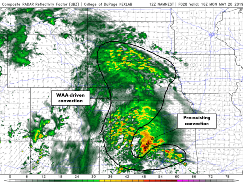
You can identify convection that is being forced by WAA pretty easily when looking at composite reflectivity charts. There is a definite "texture" pattern that is consistent with this. Check out these illustrative examples:

WAA_conv_1.png
Typically you will see very small convective cells with little spacing between them. They don't tend to max out at very high reflectivity values (rarely much higher than 55 dBZ or so) and they tend not to be rotating significantly (since they tend to be elevated and have limited vertical extent), but some of these can coalesce into larger storms with more separation and begin rotating substantially.

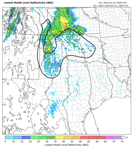
The black contour in the below image is another example of reflectivity consistent with WAA forcing:
WAA_conv_2.png
Again, look for that "speckly" appearance in the reflectivity to identify precip that is likely being driven by WAA.
 
Last edited:
Sitting here in Woodward today, with undoubtedly scads of other chasers, I came to realize (mostly from reading the 1730 D2 text) that we may be looking at a day with morning tornadoes followed by evening tornadoes. Morning garbage? Heads up, everyone, as you head for LBB? Am I wrong?
 
So begins the “Games of Torns.” Two questions remain: What modes will dominate the day and where to position tonight. I made the mistake before of setting up east, and missed the big event as massive hail, flooding, accidents, freeway closures and embedded mesos prevented me from reaching the big show near the dryline. Setting up in West Texas means being rudely awoken at around 1:00 am to the sound of watches and warnings while monitoring the mayhem including Godzilla hail from elevated storms. LBB mentioned 5” hail at some point during the event. Regardless, chasers will need to be extra careful tomorrow as any surface-based storm will have the potential to produce a violent tornado.
 
Last edited:
A couple of quick things:

The latest high resolution guidance suggests that there will be little if any substantial convection near/south of I-40 in Oklahoma through midday Monday. This is an alarming trend, which leads the latest 00z HRRR to break out numerous supercells (likely tornadic) across the warm sector and near the warm front in the afternoon.

In fact, the HRRR shows a relatively discrete/semi-discrete storm mode in most of the risk area through early Monday evening. Taken verbatim, this run would suggest, in my opinion, a higher-end, regional, as opposed to localized, tornado outbreak.

Also, there is increasing confidence in the potential for a few tornadoes as far east as Arkansas during the afternoon as well. Local climatology with a warm front near the Arkansas River Valley suggests that there will be sharply backed, channeled, flow in the vicinity of I-40. For example, winds will probably be out of the SE, if not ESE, in this area. This would locally enlarge low-level hodographs and could lead to a few tornadoes there as well. I don't think many will choose to chase there, unless they live locally, but in my view, Arkansas is under a tornado threat, too.
 
I live two hours from Little Rock and had noticed the 18z HRRR had cells tracking across central Arkansas. Haven't looked at 00z yet as I'm in terrible internet spot at present. I would stay local only if I thought they could manage to get East of Little Rock as that is the only somewhat treeless area. Doesn't look like SPC is worried in earlier outlooks. I have family and friends there so I will be looking things over very early AM. Can't see it keeping me here though. I can't pop off dates like others can but seems like i can remember and surely there have been past dynamic systems having rogue cells way out ahead of main forcing or even area considered to be the likely warm sector initiation zones.
 
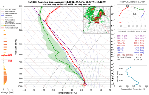
Did an area sounding using 00z 3-km NAM. Kinematics look impressive. 0-1 km SRH > 400 m2/s2. That is impressive. Also, plenty of instability. 00z HRRR shows lots and lots of discrete cells across the warm sector. The ceiling is very high for this event. I will be interested to see if the storms that form on the warm front near OKC from 8-11am turn tornadic. Could be a very long day.

18176
 
Moisture quality alone looks very impressive, which is what is helping fuel this setup, given the kinematic fields expected on Monday.

The CRP 00z sounding sampled an 80F dew-point, which is right about where their annual max is. They've only had a few occasions with a dew-point higher than 80F, with the record being an 83F in September. That case was either associated with a tropical system and/or return flow off of the Gulf, which is around peak temperature in September. Also, the DRT 00z sounding featured a 69F dew-point.

Although dew-points are in the lower 50s in the Northwest Texas vicinity now, virtually all data, which is supported by early evening RAOBs, supports the environment reaching a dew-point AOA 70F by early afternoon Monday.

There was also a question about the Dallas-Fort Worth area. The HRRR shows upwards of 5000 J/kg SBCAPE with negligible convective inhibition in that area by early afternoon. There's not much of a forcing mechanism to trigger deep convection that far south, but should a sustained storm develop, it would, conditionally, have the potential of becoming a supercell with a tornado threat. That threat would be most apparent for areas north of the OK/TX border, where deeper convection is more supported, but the entire warm sector south of the warm front looks very ominous. This includes parts of North Texas.
 
Right now I am trusting the HRRR guidance rather than NAM 3K based on real time surface data and what the last two runs have projected. HRRR has been more accurate but that is not to discount NAM 3K. Probably a 30 mile accuracy spread between the two. If HRRR verifies it will be a tornado outbreak from about Highway 33 or 51 and areas south tomorrow in Oklahoma.
 
I don't know. The data seeems to be heading south, figuratively. Straight-line hodos, morning garbage (which I earlier thought would be severe), misplaced upper level support. Gotta bad feeling tonight.
 
The HRRR has been an outlier since it first came into range 24 hours ago. While it has verified better in the "discrete vs. linear" storm mode issue quite recently compared to the HREF members, it should still be noted that it remains basically at the far right end of the forecast uncertainty distribution. Last night's NCAR ensemble was also on board with an event resembling that from the HREF. Even the HRRRE forecasts from today have not been in total agreement with the deterministic member through the early part of tomorrow.
 
Good point Jeff. Just have to go off of what I have experienced with percentage verification. The HRRR has been pretty good this year from my experience. We're pretty much in monitoring day of event real-time data now and cross-referencing with model runs. I'm sure there are a lot of chasers gulping down late night coffee crunching the current data and latest runs as I am. The Oklahoma Mesonet is going to be a busy site tomorrow.
 
Well we have a HIGH risk. I think we will see it expand to include the OKC metro in later outlooks. The TX Tech 00z WRF and the HRRR paint an ominous picture for OKC metro. Lots of discrete supercells with long updraft helicity tracks. Parameters are there. Is there a fly in the ointment? I don't think so. Stay safe everyone!

TX Tech WRF at 5pm
d02_det_sfc_dbzuh_f22.png
 
Waking up early to see far less early storm coverage much farther north than models had indicated. That seemed to be the main failure mode threat of this setup, as heavy precip would reinforce the boundary across Oklahoma and keep the warm sector from advancing north, if much at all. Some HREF/WRF runs were showing it sagging south through the day as a cold front and keeping the main juice down near the Red River. Now, a much less contaminated warm sector looks possible if not likely.
 
Back
Top