2019-05-20 EVENT: TX/OK/KS

Here is an important map for tracking that warm front today. Some models had theta-e get up into the 360 range today.
current.THTE.grad.png
 
Just my amateur opinion, and not many flies, but I see a few potential flies in the ointment. Firstly, the 500/700mb winds are almost perfectly parallel to the corresponding pressure contours and there appears to be at least some weakness in the profiles above 2-3km, so storm mode is probably going to be at least somewhat of an issue. Secondly, the environment is essentially uncapped beneath the warm front all day, and as Jeff notes, we expect several rounds of subtle warm advection initiation. This seems to be pushing the warm front more southward, but there are some model differences with HRRR lifting the warm front toward KS/OK border by 00Z and the NAM3km keeping a sharp stationary/cold front south of OKC metro by 00z. That said, advection below the front, wherever it is located, is aggressive.

During the afternoon initiation phase, I see storms over central into northern OK merging and generally becoming messy, developing in a SSW to NNE "tendril" and interfering with each other. This IMHO leaves a play on the southern edge of these "tendrils," TEC style. I would target Lawton OK as a starting point and watch how initial morning development unfolds. My expectation would be to keep an eye south and east with preference for any storm that can stay isolated east of I-44 as it moves NNE into the more favorable environment.

EDIT: has anyone seen the estimated rainfall totals through Tuesday, particularly from NAM and WRF? Stay safe out there!
 
Last edited:
I think the HRRR may have overcompensated just a bit with northward movement of the warm front, meaning I'm skeptical that the front gets far into northern Oklahoma, given a E/ESE moving convective complex in northwestern Oklahoma as of 8:30 a.m. I think it's reasonable to see the warm front get to roughly I-40 or slightly north of there, but watch convective trends closely.

In general, trends have been for a more discrete storm mode, even through early evening, along with a less contaminated warm sector. Trends still favor a few supercells eastward near the warm front into Arkansas.

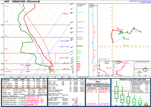
The 12z MAF sounding is very telling, to see such a volatile, high-end environment already in place at 7 a.m., this far west. This air-mass will advect northeastward, toward the Caprock region/Northwest Texas into southwestern/south-central Oklahoma. This is where the greatest potential for significant, long-track tornadoes will likely occur. If we're nit-picking, it should be noted that the dryline orientation may be SSW to NNE near the Caprock, which is close to parallel with the deep shear vectors. This is why some of the high resolution guidance is a bit inconsistent with discrete cells vs. clusters/mixed storm modes. Ideally, you want a N-S oriented dryline with deep shear vectors showing more of a westerly than a southerly component. With that said, even without "perfect or ideal" wind fields, the significant, long track tornado threat remains.
MAF.gif
 
So much like with Friday, I am limited somewhat by work today. However, I am hoping to be able to escape and get up towards either Abilene or Sweetwater, TX by 330- 400pm for a quick radar check before making a final decision from there. There are quite a few different flavors of northbound highways around there to help me adjust east/ west as I move north. With a pinch of luck, I'll be able to move up with any storms that have developed that far south. I seriously doubt I'll be able to make it up into OK before dark, and with work tomorrow as well, I will be somewhat limited to areas south of the TX/OK border. Best of luck and safe travels to everyone out there today. It could be a good one!
 
I’ll be targeting the dryline today where storms should be firing up around 3:00. HRRR has supercells remaining discreet all the way to nightfall. I’m not sure I’m buying that, but semi-discreet mode will work in a pinch too. Be extra wary on taking secondary roads today, especially to those targeting the warm front where lots rainfall has already softened up the roads this morning.
 
Special soundings by the NWS and the COD teams are showing a significantly stouter capping inversion below 700mb than forecast, which is quite possibly the biggest enhancing factor development we've seen today. All of the possible failure modes of this event have vanished, and enhancing factors like more clearing (at least filtered sunlight in most areas) and now a stronger cap have really put this event into a top-level setup in terms of the environment.
 
There's definitely something "off" about how this first round of storms is behaving. They're not acting like storms in "maxed-out" environment. We're definitely seeing rapid tendency for some level of storm rotation, but contracted low-level rotation doesn't seem to be materializing. Doppler velocities on the TX storms suggest the RFDs may be pushing through kinda hard, which may be limiting tornado performance at this time. Only the southernmost storm seems to be able to produce tornadoes right now.

As I Tweeted, I still think it's possible that storm competition can limit this event from reaching top-end performance levels. If there are just too many updrafts trying to pull in a finite amount of warm, moist air, and other storms are disrupting that, then there will be fewer tornadoes.

Things could also change as the afternoon wears on. While no area has cleared significantly, the environment in pretty much all of S OK remains undisturbed.
 
Jeff, I totally agree. There seems to be a storm mode issue given the deep shear vectors parallel to the dryline and pressure gradient, especially west near the greater forcing close to the dryline, as one would expect. But note the isolated cell in Kingfisher County that has gone bonkers, as should be expected given the environment. The unexpected capping inversion sampled at DFW seems to be a harbinger of more such cells later this afternoon. The HRRR has been more bullish on breaking out such cells, while NAM and WRF have been consistent for a while in a relatively undisturbed central OK getting blasted by messy storm mode around 00z.
 
Jeff, I totally agree. There seems to be a storm mode issue given the deep shear vectors parallel to the dryline and pressure gradient, especially west near the greater forcing close to the dryline, as one would expect. But note the isolated cell in Kingfisher County that has gone bonkers, as should be expected given the environment. The unexpected capping inversion sampled at DFW seems to be a harbinger of more such cells later this afternoon. The HRRR has been more bullish on breaking out such cells, while NAM and WRF have been consistent for a while in a relatively undisturbed central OK getting blasted by messy storm mode around 00z.
 
Not much in the way of new development east of the DL and south of the WF lately. Not exactly sure why (maybe just too much cloud cover), but given the next wave has popped down by Lubbock and storms now filling in from there up through NC OK, I'm starting to think the evolution upscale into a big line has already commenced.
 
Not much in the way of new development east of the DL and south of the WF lately. Not exactly sure why (maybe just too much cloud cover), but given the next wave has popped down by Lubbock and storms now filling in from there up through NC OK, I'm starting to think the evolution upscale into a big line has already commenced.
NAM this morning was indicating some slight warming in the mid-levels through 00z, with 700 temps in the 10-12C range over SW OK, which appears to be verifying according to the SPC mesoanalysis page (and possibly also implied with the mid-day FWD sounding). Been wondering for awhile if this is the reason.
 
This could also be the classic case of "1 CIN in the 00Z OUN sounding is good enough to restrict CI because there is no other lift". We see that many times in C OK.
 
Back
Top