2019-05-20 EVENT: TX/OK/KS

Jeff Duda

site owner, PhD
Staff member
Site owner
Supporter
Joined
Oct 7, 2008
Messages
3,783
Location
Denver, CO
On the synoptic scale, this event has consistently appeared as a potentially high-end event. A broad trough across the W CONUS with a backloaded jet core (i.e., concentrated on the western side of the trough) has persisted in the forecast, and a subtle embedded shortwave appears to swing over the southern Plains with a negative tilt that is pretty well timed for Monday. SW mid-level jet winds approaching 70 kts combined with mostly due S 850 winds at 40-50 kts makes for some incredible mid-level shear. Low-level flow out of the SE across OK makes for a hell of a kinematic environment. Quality moisture will be present, but as of now, there are questions as to whether we will only see mid-upper 60s dews or Tds exceeding 70 F in the warm sector.

What appears to be a major limiting factor with this environment is diurnal convection to screw up the thermodynamic and kinematic environment. There are lots of signs of overnight/early morning convection developing in "the chase killer zone" of WC TX in the 06-12Z time frame. This makes sense given the strong large-scale forcing ahead of the approaching shortwave combined with rapid and sudden moisture return and WAA in the area the night before. What makes this happen is that the EML coming from the source region just isn't that warm for this time of year - 700 mb temps only get to 10-12 C in S TX/NM and northern Mexico preceding this event. That's just not going to be enough to restrict early convective development.

Whether this morning convection verifies remains to be determined (although I don't see much reason for it not to), but the extent, timing, and intensity of the cold pools/stabilization it leaves in its wake will largely determine the spatial and intensity extent of this event. If morning convection is minimal or gets out of the way quickly enough, there would be more time for recovery/destabilization and this could end up being a significant severe weather outbreak.
 
For the time being I think the convection is sure to happen, no reason to believe it won’t. To the south of this convection, mainly across the Permian basin E/NE into the Wichita Falls/Abilene area, a significant severe threat may still evolve. Wind profiles here would suggest a discrete supercell event south of the effective warm front with a mixed mode closer to the front. Significant tornado potential would appear to exist here. It’ll be a bit before we know where the threat is maximized but I’m thinking the I-20 corridor east towards closer to 35 could see significant tornadoes. I’m less sold of anything of significance happening N of the RR but uncertainties exist on that front.
 
The warm front in S KS and N OK will need to be watched, per the 12z/17 NAM. It seems to be hinting at convection breaking out early evening INVO of the warm front, in an otherwise favorable environment. I don't know how the early convection in WC OK will affect that region in regards to moisture quality or instability parameters being materialized to a full potential, but that's definitely something to watch based on the recent model trends.
 
The warm front in S KS and N OK will need to be watched, per the 12z/17 NAM. It seems to be hinting at convection breaking out early evening INVO of the warm front, in an otherwise favorable environment. I don't know how the early convection in WC OK will affect that region in regards to moisture quality or instability parameters being materialized to a full potential, but that's definitely something to watch based on the recent model trends.
I agree.
This day is perhaps going to be an all or nothing type event. The hype being generated right now is somewhat disturbing with lots of mesoscale features yet to be determined. High end, high impact potential is there but there's plenty of ways this could bust at this point. There are still indicators that convection starts really early, yes shear will be impressive, or at least appears to be the case now, but that's no guarantee.
 
I'm pretty disgusted at the amount of cold air north of the warm front, especially in KS, along with the northerly surface wind vectors. Kinda resembles today in which the western extent of the warm front in NE didn't seem to materialize as it had been forecast at some point (i.e., there wasn't much in the way of Ely flow north of the thermo gradient; rather it was basically just a cold front). I'm worried that cold air is going to just take over and flush out the environment, especially considering the amount of convective activity progged to occur across W KS/TX&OK PHs during the day.

You can tell me all you want about dynamic forcing and how that will keep the thermodynamic environment healthy throughout the event. Perhaps...but in 2019 the cold air has just not gone away yet. Still getting 40s behind fronts in mid-late May...disconcerting to me.
 
Last edited:
I think the difference between yesterday and a day like Monday is the *deep* nature of the rich gulf moisture on tap.. That + the strong SSEly flow regime is going to keep the cold air at bay.. Short of a raging MCS, I don't see the front stalling too far south.. But I could be wrong. This is a pretty rare kinematic regime for the Plains.
 
I'm pretty disgusted at the amount of cold air north of the warm front, especially in KS, along with the northerly surface wind vectors. Kinda resembles today in which the western extent of the warm front in NE didn't seem to materialize as it had been forecast at some point (i.e., there wasn't much in the way of Ely flow north of the thermo gradient; rather it was basically just a cold front).

I know this thread is about 5/20 but wanted to note your comment above re: 5/17. I wasn’t following the changing model runs consistently since I couldn’t chase anyway, but I did notice both the 6Z NAM and 12Z RAP were already showing the western segment of the fron as more of a cold front. Not sure exactly when the models started to pick up on that.
 
Back to 5/20... I haven't been monitoring the models every day since I can't chase anyway, but looking now at today's 12Z GFS it looks like the concern @Jeff Duda had last night may be disappearing. This run shows a nice sharp warm front near the KS/OK border with ESE winds along it. SPC Day 3 notes lifting of the warm front from the Red River in the morning to the KS/OK border by later in the day, also evidenced by the 12Z GFS run. This appears to be commensurate with a strong LLJ that will exist throughout the day - also noted in the SPC Day 3 - so the main concern for me would be elevated early-day convection forming as the LLJ crosses the warm front. I'm not technical enough to know if that's correct, but just from pattern recognition I feel like having such strong dynamics so early in the day never bodes well for chasing. But I'm probably wrong as SPC still seems bullish on this event and specifically talks about conditions being favorable for discrete supercells, nothing about MCS formation until later in the day/evening.
 
Back to 5/20... I haven't been monitoring the models every day since I can't chase anyway, but looking now at today's 12Z GFS it looks like the concern @Jeff Duda had last night may be disappearing. This run shows a nice sharp warm front near the KS/OK border with ESE winds along it. SPC Day 3 notes lifting of the warm front from the Red River in the morning to the KS/OK border by later in the day, also evidenced by the 12Z GFS run. This appears to be commensurate with a strong LLJ that will exist throughout the day - also noted in the SPC Day 3 - so the main concern for me would be elevated early-day convection forming as the LLJ crosses the warm front. I'm not technical enough to know if that's correct, but just from pattern recognition I feel like having such strong dynamics so early in the day never bodes well for chasing. But I'm probably wrong as SPC still seems bullish on this event and specifically talks about conditions being favorable for discrete supercells, nothing about MCS formation until later in the day/evening.

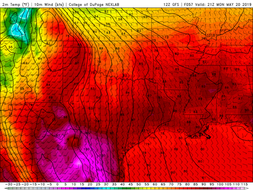
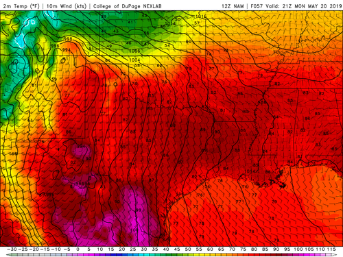
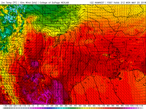
The GFS is notorious for underdoing the extent of cold air. It always shows a nice lifted warm front where the NAM shows a plowing cold front, and this case is no different. In fact, in this particular instance, the CAM NAM shows an even more significant plunge of cold air into OK than the 12 km NAM.

GFS:
GFSSGP_sfc_temp_057.png

12 km NAM:
NAMSGP_sfc_temp_057.png

3 km NAM:
NAMNSTSGP_sfc_temp_057.png

The big difference here is the shape of the surface pressure field. A warm front is only a warm front when the cold air is pulling away from the boundary. If it is into the boundary, then the boundary is a cold front. If it is parallel to the boundary (as the NAM seems closer to indicating) then it is really a stationary front, although there is some Nwd movement of the boundary along the eastern flanks of it (C KS).
 
I hope this is okay to ask this question. Is anyone “concerned” with the only 1-2 degree difference between temperatures and dew points? I know low cloud bases are nice but at some point having clouds basically on the ground leads to ugly low visibility tornadoes. I always like to see a tornado but unsure if a long drive would be worth it for “ugly” tornadoes 😊
 
I hope this is okay to ask this question. Is anyone “concerned” with the only 1-2 degree difference between temperatures and dew points? I know low cloud bases are nice but at some point having clouds basically on the ground leads to ugly low visibility tornadoes. I always like to see a tornado but unsure if a long drive would be worth it for “ugly” tornadoes 😊

Jeremy, not being a met I’m not sure of the technical answer but I would think low LCL’s like that, combined with the forecast kinematic environment, could lead to an El Reno type of situation where the entire meso is basically on the ground. But others can correct me if I am wrong.
 
I would put the odds of Monday being the "High Risk" day everyone is talking about at about 50/50. I think a large part of what happens will depend on how far quality moisture pushes westward into eastern New Mexico and West Texas on Sunday through early Monday morning. If the DP's stay low, and limited storm coverage occurs, then it's a different story later in the day -- if the dryline remains west long enough to take advantage of any recovery. In reality, this could easily become a big mess with lots of storms forming with embedded mesos eventually forming a severe squall line.

If you wake up in Amarillo on Monday morning and the skies are partly cloudy or clear, then expect all hell to break loose later in the day. If it's cold, raining and overcast, then the odds are it's not gonna happen. Then again, somewhere further south, the atmosphere may not be as stabilized.
 
While this setup arguably has one of the highest ceilings of any event we've seen over the past five years in the High Plains vicinity, there are still some concerns and questions that I have.

Storm mode is something to watch out for, as many convection allowing model (CAM) solutions show a relatively quick-to-linear evolution. There's also the issue about early day convection overturning the environment, especially across western/central Oklahoma. One could argue that such a scenario may reinforce a thermal boundary and/or lay down an outflow boundary, but the GFS/Euro/RGEM precip fields show a large amount of convection blowing up by late morning/midday. The 3km does to a lesser extent, but that scenario would not be overly deleterious.

What is pretty impressive is the degree of instability being progged across relatively higher terrain, in the Lubbock-Midland-Fort Stockton corridor. This is 3,000-4000 J/kg MLCAPE on the consensus, with the GFS being closer to 3,000, but the 3km NAM showing areas well over 4,000 J/kg.

One thing to note is that just because there's an overlap of strong/extreme instability and substantial wind shear does not automatically equal a discrete tornadic supercell outbreak. Case in point the 5/18/17 tornado-driven high risk, although I am NOT saying this is the same type of setup. We also had that moderate risk later in May 2017 that was very grungy/underperforming across eastern Oklahoma.

The highest confidence I have at this stage in tornadic supercells will be with the dryline across West Texas, but we'll see how trends look during the day on Sunday.

Edit to add this:
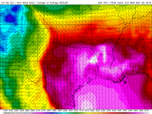
While overturning may be an issue, if low-level south to south-southeasterly winds are 15-25 knots through the afternoon, that's going to allow for quick recover for any areas that are not completely demolished by early day convection. You could even have a situation in this case where there's convection around midday, but if it pulls out and return southeasterly flow is as robust as progged, then you very well may recover by 22-00z. (I understand that the GFS is probably too far north with the warm front, but this graphic is just to give a rough idea of the return flow/moisture recovery)
GFSSGP_sfc_thetae_045.png
 
Last edited:
I hope it's OK to add a question in here as it's relevant to the setup. SPC in its 6Z Day 2 says the following:

"Large-scale forcing for ascent is expected to be negligible until after 00Z, resulting in some uncertainty regarding the primary mechanism for convective initiation within the warm sector. One mechanism will be the dryline, which could act to initiate multiple rounds of storms over the TX Panhandle before it surges eastward after 00Z. Another forcing mechanism will be warm advection, where storms would initially be elevated but could become more surface-based as intensity increases. Both of these mechanisms suggest a predominantly discrete mode, although the warm advection mechanism leaves some uncertainty where the most favored region for initiation would be."

How/why would warm advection support a "predominantly discrete mode"? Isn't warm advection-driven convection, from the LLJ being in place throughout the period, one of the potential negatives we see in Monday's setup?
 
Back
Top