2019-05-20 EVENT: TX/OK/KS

...As I Tweeted, I still think it's possible that storm competition can limit this event from reaching top-end performance levels. If there are just too many updrafts trying to pull in a finite amount of warm, moist air, and other storms are disrupting that, then there will be fewer tornadoes...

MSD #710 (covering SW TX up through SE TX PH) bears this out:

“...So far, tornadic activity has been limited by the number of storms ongoing in relative close proximity...”

Impressive event so far, but fewer tornado reports and even warnings than I would have expected given the setup. But it’s still early, still a dangerous night ahead for residents.
 
This could also be the classic case of "1 CIN in the 00Z OUN sounding is good enough to restrict CI because there is no other lift". We see that many times in C OK.

You may very well be correct. Seeing the 21z sounding had me worried, but it just diidn't materialize.
last.gif


UPDATE:

And now we can compare to the 00z sounding. It was all there except that bit around 700 mb. Storms just couldn't push through. And no other forcing mechanism. The greatest outbreak that could have been.

last.gif
 
Last edited:
Those lapse rates are scantily clad on that 0z sounding data, and I can't help but wonder how the ongoing cirrus impacted that, which I believe was a huge factor with the short-range models being overly magnanimous on the amount of uninhibited solar insolation that the warm sector was progged to experience. It does look like the main jet streak was a bit tardy so that, when coupled with the increased CIN (met on social media was noting that 700 mb temps increased by 8 degrees between 3 and 6 p.m. today per the afternoon balloon launch), kept much of the warm sector largely unmolested by storm activity through the daytime. The 0-6 km shear vectors were parallel to the surface boundary, and the baroclinicity along the NE-SW oriented boundary across NC OK was nothing short of a prodigious fly in the ointment.
 
Lots of failure modes today, but a few rogue storms went to town and West Texas lit up, pretty close to what was expected down there. Forcing in the warm sector was weak to non-existent. There was a large area of extreme instability/favorable shear, from North Texas into southern/central Oklahoma. I wonder if the HRRR has a bias of overconvecting when there's marginal/minimal forcing involved. I know I've seen it a few times this year, most notably in southwestern Kansas. On the other hand, on the dryline day, it struggled to convect. Leitman mentioned how there was a bit of a 700mb thermal ridge over Oklahoma. I vaguely recall seeing this on mesoanalysis, but just assumed that it would advect east as the trough impinged on the High Plains. Too little, too late. Convective modes were messy. Outflow across Oklahoma started overtaking storms by mid-afternoon. What else?

There was also a case with some really funky hodographs. FDR was junky looking early on, especially in the mid-levels. 700mb winds were backing a bit over Oklahoma and although it did improve with time, it wasn't an ideal enough wind profile to support long-tracking tornadoes into southwestern Oklahoma. The MAF hodograph was awful looking in the afternoon too. Low-level shear in southern West Texas was marginal for most of the event, but with time, it did become more favorable toward and after 00z.

It's rare that you have an outbreak where the dryline, warm front AND warm sector all light up. We had two of those three go and then that random tornado northwest of Oklahoma City. As mentioned, the timing of the jet streak did slow down a bit. West Texas (northern part) could have lit up sooner, but the initiating boundary was just about parallel to the deep shear vectors.

All around, it was a complex setup. It was a case where the HRRR really did not perform very well at face value, but you have to wonder if it was just a small change/error in its initialized conditions that were enough to throw the warm sector into supercell-chaos. The parameter space was there, but high shear/high cape does not automatically imply a tornado outbreak, especially if there's little to no meaningful forcing.

A lot to learn and reflect on, but I'm glad that this event failed to meet expectations. The main reason being the large population center that was at risk, but also because of the extreme chaser convergence. It could have gotten really ugly, but thankfully it did not.

Personally, I think this event is leading me to try to be more objective and reasonably skeptical in the future. I almost always lean on the HRRR (not 100%, but a heavy lean), but now I may be a bit more skeptical. Also, even though I didn't practice what I often preach, an extreme parameter space does not automatically result in a supercell tornado outbreak.

End of rant.
 
And now we can compare to the 00z sounding. It was all there except that bit around 700 mb. Storms just couldn't push through. And no other forcing mechanism. The greatest outbreak that could have been.

I saw at least one person tweet an OUN obs sounding today claiming [sic] "I have never seen such a tornado-supportive sounding".

Meh.

Certainly some impressive parameters, but consider a few things:
1) next to no shear between 2 and 4 km (actually, 0-4 km SRH < 0-3 km SRH due to slight backing between 3 and 4 km); if everything else went right, this would probably not be enough to restrict sig tors from forming, but...
2) likely subsidence inversion just above 700 mb; not only a CAPE robber (hurting vertical accelerations), but also suggestive of downward moving air in that layer, further restricting explosive development;

and perhaps most intriguing and subtle...

3) Very deep nearly-saturated inflow layer. I was involved in a lengthy Twitter discussion with another PhD meteorologist and severe weather expert:


...discussing the potential impacts of a deep layer with approximately d(theta-e)/dz = 0. It seems quite plausible that the effect of this feature was to allow for inflow parcels to originate at just about any level between sfc and the bottom of the inversion. Well, if parcels enter higher up then, 1) they aren't surface based anymore, and 2) those parcels pass through a much different shear profile on their way up with much less propensity to generate vorticity from tilting. Both of these factors, but especially #2, can complicate storm structure and behavior.

Again, details matter. You cannot claim "massive tornado outbreak" from just synoptic scale pattern + mesoscale situation (i.e., CAPE, shear, composite parameters maxing out).
 
The HRRR has been an outlier since it first came into range 24 hours ago. While it has verified better in the "discrete vs. linear" storm mode issue quite recently compared to the HREF members, it should still be noted that it remains basically at the far right end of the forecast uncertainty distribution. Last night's NCAR ensemble was also on board with an event resembling that from the HREF. Even the HRRRE forecasts from today have not been in total agreement with the deterministic member through the early part of tomorrow.

BTW, I'm going to start tooting the shit out of my own horn here, because I feel reasonably vindicated with just about every post I made in this thread. But the one quoted above is most prominent to me, and it's one I want everyone to pay attention to.

I know most of you here are not degreed meteorologists and are not researchers and thus are not totally informed as to all the tools out there. Thus it makes sense that so many of you seem to live and die by the HRRR, since it is arguably the most prominent CAM (and, in fairness, it does tend to provide a lot of helpful information and value for forecasting over non-convection-allowing models). However, it is not the only CAM out there, and is not even the only operational CAM. Those of you not already familiar with the HREF need to become familiar with it. Start here: SPC HREF viewer site

The 3 km NAM is a member, as is the HRRR. The HREF gave a lot of clues that this event may not turn into a massive tornado outbreak all the way from when the first members had this event in range.

While non-operational, the NCAR ensemble is running for the next few weeks as part of the HWT spring forecasting experiment in Norman. This happens every year. NCAR Realtime Ensemble Forecasts

Also, the HRRR has an ensemble component: HRRRE viewer site

Familiarize yourself with these other CAMs and CAM ensembles, because many of them will stick around, and one of them is bound to eventually supersede the HREF as it currently exists.

It would be unwise to cherry pick the HRRR or wishcast off of it. The most sensible thing you can do as a forecaster/chaser is to collect all the information you can and make a decision based off of the consensus of that information, not just the sexiest voice.


Toot away, Jeff, toot away. I stand corrected. I was one of the guilty parties. Always you can learn something from events like these.
 
3) Very deep nearly-saturated inflow layer. I was involved in a lengthy Twitter discussion with another PhD meteorologist and severe weather expert:


I really appreciate your posts. I thought that the 21Z OUN looked pretty odd with the moist layer extending up to almost 600mb! This theory regarding why that may have been an issue makes a lot of sense to me.
 
I saw at least one person tweet an OUN obs sounding today claiming [sic] "I have never seen such a tornado-supportive sounding".

Meh.

Certainly some impressive parameters, but consider a few things:
1) next to no shear between 2 and 4 km (actually, 0-4 km SRH < 0-3 km SRH due to slight backing between 3 and 4 km); if everything else went right, this would probably not be enough to restrict sig tors from forming, but...
2) likely subsidence inversion just above 700 mb; not only a CAPE robber (hurting vertical accelerations), but also suggestive of downward moving air in that layer, further restricting explosive development;

and perhaps most intriguing and subtle...

3) Very deep nearly-saturated inflow layer. I was involved in a lengthy Twitter discussion with another PhD meteorologist and severe weather expert:


...discussing the potential impacts of a deep layer with approximately d(theta-e)/dz = 0. It seems quite plausible that the effect of this feature was to allow for inflow parcels to originate at just about any level between sfc and the bottom of the inversion. Well, if parcels enter higher up then, 1) they aren't surface based anymore, and 2) those parcels pass through a much different shear profile on their way up with much less propensity to generate vorticity from tilting. Both of these factors, but especially #2, can complicate storm structure and behavior.

Again, details matter. You cannot claim "massive tornado outbreak" from just synoptic scale pattern + mesoscale situation (i.e., CAPE, shear, composite parameters maxing out).

Jeff this lines up with the satellite presentation on the storm from El Reno toward Crescent. Even though that storm did produce a tornado, while lookin at it on satellite it never had that explosive look. The anvil never really spread out which told me it was struggling somehow. The 1-min and 30-sec meso sector yesterday was a great tool to look at. The storm did have a decent radar presentation while producing a tornado, but it never had that explosive satellite look.
 
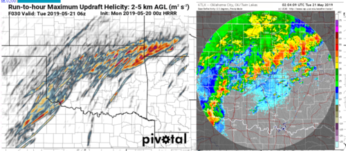
Up along the warm front by evening, Sunday night's HRRR actually didn't end up seeming to be too far off in terms of having some exciting strings of structure eventually... it's just that the outflow was 10 miles out of ahead of just about all the mature storms by that point. [Don't suppose anyone knows any sites that hold HRRR graphics longer than a day, other than the work needed to translate the GRIB at http://home.chpc.utah.edu/~u0553130/Brian_Blaylock/hrrr_FAQ so a better side by side reflectivity comparison can be shown for that time rather than the broad time frame of the run-max plot I happened to have?]

Some of the forecasted supercell structure within the line for the late evening period certainly caught my eye in the Sunday evening HRRR run (perhaps because I'm outside the region for the event and so not focusing on chase targets... I didn't check whether they were surface based by then?) And seemed those elevated storms did at least do reasonable at verifying their anticipated structure once they got the extra oomph/focus of the boundary... so perhaps Jeff/SRHelicity's option #3 (also echoed by Jeff Snyder on FB/Twitter) of the saturated low level parcel proves most notable indeed? Certainly going in the memory banks, and would be interested to see if studies show it as a major trend that needs to be included in severe weather parameters?

18225

(The HRRR did also actually seem to do relatively well [from what I can remember] in the Sunday evening run with the positioning of the warm front compared to the 3km NAM, which instead brought it up further on into southeast Kansas for a little while during the afternoon [the NAM seemed more an outlier in that regard]. Plus perhaps was pretty good with the potential in eastern Oklahoma and SW Missouri, if the MUH plot may be suggesting that?)
 
Last edited:
BTW, I'm going to start tooting the shit out of my own horn here, because I feel reasonably vindicated with just about every post I made in this thread. But the one quoted above is most prominent to me, and it's one I want everyone to pay attention to.

I know most of you here are not degreed meteorologists and are not researchers and thus are not totally informed as to all the tools out there. Thus it makes sense that so many of you seem to live and die by the HRRR, since it is arguably the most prominent CAM (and, in fairness, it does tend to provide a lot of helpful information and value for forecasting over non-convection-allowing models). However, it is not the only CAM out there, and is not even the only operational CAM. Those of you not already familiar with the HREF need to become familiar with it.....

Jeff, not to speak for everyone but I’ll venture a guess that we all appreciate not just your technical knowledge/contributions but also your measured conservatism that helps us keep our hopes and expectations in check!

Also your comment about us non-mets not being informed on all the tools is dead-on. This is something that often frustrates me. I have a hard enough time keeping up on developments in my own field of finance and accounting, not to mention developments in the industry I happen to work in (home healthcare), so how the hell can I also keep up on all the modeling changes, biases, etc.? I don’t even have the background in math, physics or meteorology to understand enough about them even if they weren’t changing so rapidly every year. The suggestions and links you provided are a big help, and it would be great to get a separate thread going on the state of the current tools and their biases. I am sure this exists somewhere, but I’m talking in layman’s/chaser’s terms.

Anyway, I’m glad I didn’t drive myself nuts about missing yesterday or trying to fly out there just for that. There is always more downside than upside in events like this. If some of the storms went to town as they did, even with the limiting factors mentioned above, that goes to show how incredible the dynamics really were. It could have been much worse, so we should be happy for the folks that live in the area. Although from a chaser’s perspective the outbreak was somewhat disappointing, it also shows that you don’t need an outbreak to have a great chase day. You can generally only chase one supercell at a time anyway, so as long as you’re on one, who cares how many other ones are happening??
 
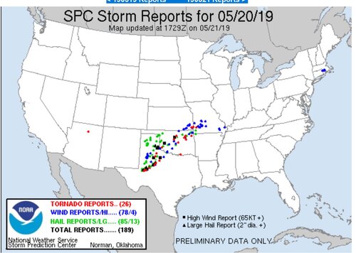
Granted I didn't spend much time studying this event since I knew I could not chase (my whole season is non-existent thanks to my new career as 'starving artist') but I'm a bit puzzled by all the pooh-pooing of the forecast yesterday. A good percentage of high risk days never produce photogenic EF-4s. If you look at the report map, it certainly looks like it could qualify as a regional outbreak. I'm sure the chase sucked for most but honestly looking at radar signatures the morning HRRR forecasts seemed pretty spot on to me...they captured the mess in OK and the discrete cells in TX, and the forecast in general was pretty good in delineating the aerial threat. It's easy to get excited and wish-casty about any day with big parameters--its just as easy to afterwards say 'i knew it' that the atmosphere doesn't always obey your wishes.
18229
 
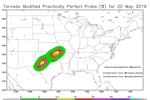
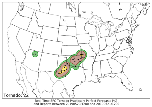
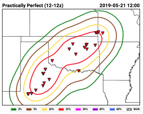
BTW, the way convective outlooks get verified is by something called Practically Perfect (Hindcast/forecast), or PPF. A few websites out there mimic this behavior, but because they differ on specifics of the equation, you get somewhat different results. Here are the results for the tornado aspect of yesterday's forecast:

This one appears on Victor Gensini's website: SPC Practically Perfect Hindcast (with an archive that goes back a fair ways)
tornado_current.png

This one is available on the St. Louis University's CIPS website (CIPS Real-Time SPC Practically Perfect Forecasts)
201905211200_ppfTorn.png

This other one is not available to the public, but is an example of what goes on at the spring forecasting experiment at the Hazardous Weather Testbed in Norman:
Screen Shot 2019-05-21 at 12.49.29 PM.png

Note that the above will not include any hatching for significant reports due to EF-scale ratings not known at the time of image creation.

You can see clearly here that, even in the most friendly scenario, only a moderate risk would have verified for tornadoes. In more conservative cases, barely and enhanced risk would have verified.

It is possible that some tornadoes occurred for which LSRs (on which these PPFs are based) have not been issued yet, so technically this could change in the future, but it will take months before Storm Data's official count for this event is released, so for the time being, this should be considered very close.
 
Last edited:
Back
Top