Total Solar Eclipse April 8, 2024 weather prospects

Latest models maintain the trend of that leading warm air advection arc of clouds inching farther northeast. Surely there will also be some cirrus ahead of that. If that keeps up, I don’t see *any* good options. I’m heading northeast today, but pretty pessimistic. I can get back to Ohio potentially if there is a better break there behind the WAA arc.
 
I love chasing but to me the 2017 eclipse was the single most awe inspiring moment of my life and would choose it over any tornado, especially since the next total eclipse in the US is 20 years from now.

This is awesome and I would too but given that I can't control the weather it seems it would be more taxing mentally and financially at this point to try to see it than the benefit of trying to replicate my experience in 2017. Plus, I got to experience the annular eclipse late last year which kind of helps ease the pain of most likely missing out - although it's not over yet so plans may change.
 
From a pattern recognition standpoint, clearing in the Midwest behind the WAA precip seems reasonable and is something we see all the time with Plains systems. The cirrus encroaching on that area is shown developing in Texas (rather than advecting in from the Pacific or Mexico) and riding the jet rapidly northeast. So it seems likely that there will be a hole in the Midwest behind the WAA clouds that fills in from southwest to northeast with the cirrus throughout the day. I’m now giving some thought to staying with the back edge of the WAA clouds and hoping the cirrus slug holds off long enough to get the eclipse in. Indiana and Ohio look like they have the best chance of that. Will keep watching that option and make the call tomorrow.
 
Sunday midday is the point of no return for me - decision time to stay Sunday night in Bangor for a Maine target, or NH for a Vermont target. It looks like more of Vermont is getting pinched off by clouds, and there is not a good road network to adjust into western Maine from there if needed. If I choose to stay in Bangor tomorrow, it would be to target eastern Maine. Western Maine would be equally in reach, but the road network looks like it really sucks there.
 
I checked into my hotel in Dyersburg TN so I am pretty sure I am going there. I figure if I need to make a run at Ohio I could be on the road early and make it almost to Indy before eclipse time. Would love to be able to back southwest to Arkansas and get home fast.

I hope this isn't like chasing where if you take the targets and split them you end up with poo (2012-04-14 anyone?)
 
I feel like western Maine is probably my best shot between approaching clouds from the southwest, and clouds from the system to the east. But the road network sucks there and there are so few services - not a good situation with three females in the car.
 
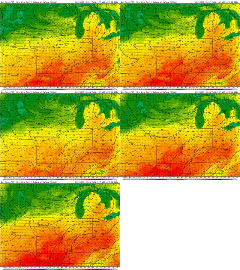
Well, here it is, folks. A total solar eclipse's impact on 2-m temperatures from an NWP model that parameterizes eclipses via the reduction in incoming solar radiation:

CODNEXLAB-FORECAST-2024040700-HRRR-MW-sfc-temp-41-45-100.gif

Did you see it? The 1-hour "blip"/drop in temperatures at 19Z? That's it.

If you go to your favorite forecast graphics site and view this in detail, you'll notice that the 2-m temperatures over the 3-h window centered on the eclipse still rise a little. This shows that the impact on 2-m temperature is fairly mild outside the hour-or-so window near totality.

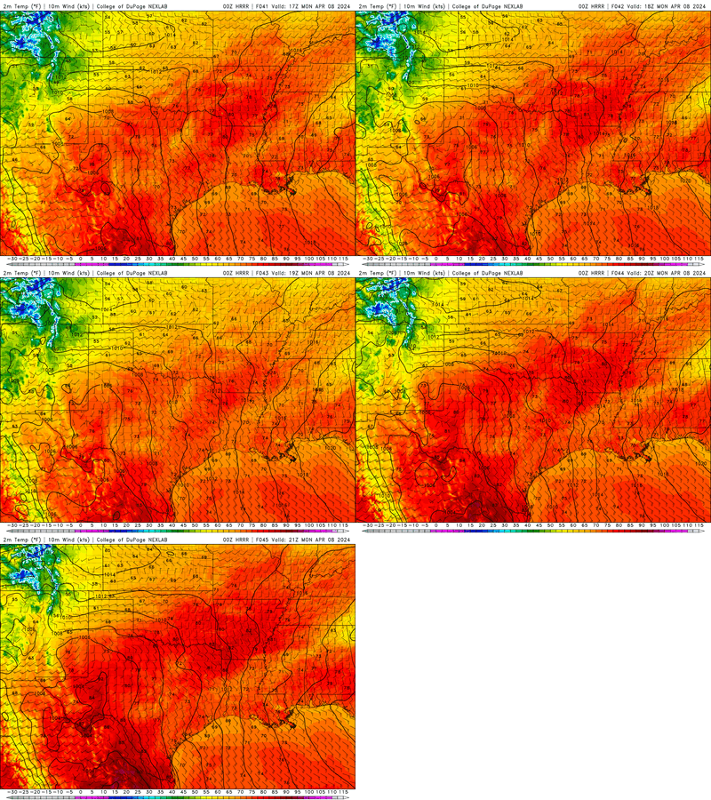
Let's see it somewhere else:
CODNEXLAB-FORECAST-2024040700-HRRR-SGP-sfc-temp-41-45-100.gif

Do you see it in Texas? Yeah, I didn't either. At most text-labeled locations there is essentially no temperature change across the 17-19Z window (maybe 1 F in some isolated spots).

I suspect the relative lack of temperature change in TX compared to the Midwest/Ohio Valley is indicative of the extensive cloud cover in the HRRR's model atmosphere. The cloud cover dampens the signal due to the substantial downwelling longwave radiation that clouds promote.

Some of these surface energy budget terms can be visualized on GSL's HRRR forecast graphics site: https://rapidrefresh.noaa.gov/hrrr/...t&domain=full:hrrr&run_time=07+Apr+2024+-+00Z

Check out the sensible and latent heat products for another good depiction of the differences of this eclipse by location along the path.
 
Heading northeast out of Pittsburgh this morning. The Ohio option looks like a possibility still, but looks more vulnerable to cirrus overspreading. New England looks most consistently clear on all available models. We'll have time to get back west if it appears necessary later this afternoon. Our final decision time is around 2pm or so, but I think we're locked in to NH at this point. Planning to be on the road at 3am this morning to get a spot staked out hopefully before the crowds arrive.
 
After Sunday morning's analysis, I am heavily leaning toward Maine. I would much rather make my target Newport VT, but it feels too close for comfort, with clouds approaching from the southwest. Some of the models only have 18Z and 0Z valid times available (no 21Z). Totality in New England is at around 19:30Z, so the models could easily be slightly slow or slightly off geographically with the approaching high clouds. Once up in northern VT near the Canadian border, there is no practical way to adjust to the east. The Euro has been very consistent with its placement of the edge of clouds in western VT, but again that's at 18Z so there's just not enough of a temporal or geographical safety buffer in there. The Euro's 300mb RH lines up well with its cloud cover in the region. The Canadian, which shows clear skies in most of VT, has a similar look to its 300mb RH to the Euro, although the moisture value is lower. I think I will most likely head to Bangor, which leaves both western Maine and eastern Maine in play tomorrow. Downsides being the road network in western Maine, and generally longer drives into the path than I would have had to Vermont from my New Hampshire hotel. I'll make one more check around 2pm ET before pulling the trigger.

EDIT - I feel like northern VT could be OK, and that's where I would rather be for the road network and more services in the towns. But Maine seems like more of a slam dunk (although the Portland ME AFD does also mention some thin cirrus moving in). After all this time and money, why take a chance on VT if I can still get to Maine? Curious to others thoughts on this, particularly @Dan Robinson because I know you have also been studying New England whereas that's not an option at this point for others in this thread. Eastern Maine seems like it has the best combination of weather and road network, but is that too close to the upper low? The cloud models don't seem concerned by it...
 
@JamesCaruso Have to say I'm fascinated with your "chase" in New England (you don't hear that phrase often here) and hoping you'll share your experience once you've returned from your trip. Good luck tomorrow!
 
I see a lot of discussion of the likely cirrus cloud cover, and it certainly appears likely that there will be some over much of the path. I am mainly interested in the MO/IL part, and there, at least, I am at least cautiously hopeful that ti will be thin enough to have minimal impact on viewing the ecliose. Cirrus can get thick enough to be a problem, but often it is not, and at least the cloud thickness model output I could find showed only 5-15% obscuration over my area of interest, which probably will not make a big difference if that verifies. It would be better to have it totally clear like we had in 2017 in Nebraska, but I could live with some thin cirruw.
 
James, I'm in agreement with your synopsis. For non-diurnal weather events (like the arrival of an overnight MCS for lightning photography over St. Louis or Chicago), I always allow for plus or minus 4 hours' margin of error on model depictions. The 12z HRRR shows the edge of the cloud deck reaching the Maine border at 23z, so that would put western Maine safely within that 4 hour margin of error.

The good news is that we should know what the cloud situation is going to be by 7 or 8am once the first couple of visible satellite images are available. We're planning on an adjustment northeast to Eustis should that become necessary.
 
I’m fairly fortunate to live in Arkansas, but the clouds are a big concern, like most of the totality path is. My wife and I will just head out and I’ll try to time a gap in the cloud cover to the roughly four minutes of prime time if necessary. The models are all over the map still so it will be just like a chase day where I spend the late morning hours staring at GOES.
 
Here is the forecast I made earlier this afternoon. Because there are lots and lots of people who don't understand meteorology, I did a brief primmer on cloud types as well as severe weather coverage. Eclipse Forecast

Based on two eclipses, do not underestimate the amount of gridlock after the eclipse.
 
Stuck with Dyersburg and was greeted by a nice little supercell as I arrived earlier. Pretty hopeful on cloud free chances tomorrow somewhere between I-70 and I-40, which is theoretically do-able with an early morning wake up and first view of vis sat tomorrow.

Wonder where they'll put the GOES meso sectors tomorrow. One will undoubtedly be Texas.

Also never considered the fact that traffic will be gridlocked in Texas most likely, with possibilities of sitting ducks for tornadoes or large hail. Yikes.
 
Back
Top