Tornadoes with Tentacle Like External Vortices!!

Good day all...

I saw these same features on the violent Rice county, Kansas tornado on April 14, 2012.

m13tor10.jpg


http://www.sky-chaser.com/image/mwcl2012/m13tor10.jpg

This is the view looking to the NNW from near Geneseo, Kansas on April 14th (2012). The vortex "filament" or "tentacle" appears to be just ahead of the tornado in it's path as it is moving to the NE at over 35 MPH.

I see this phenomina on fast moving tornadoes. I believe two things may be at play ... One, the fast motion of the "parent" (main) circulation overspreading the slower moving (relative to the storm motion or even opposing) inflow air at the surface. I remember seeing a presentation at ChaserCon about this - With some pretty complicated mathmatics / equations - Referring to it as "vortex shedding".

Second, the storm could be "riding" along a boundary, or even the FFD, where a horizontal rolling of the air ahead of the tornado is being stretched just before entering the "upward" orientation closet to the tornado's leading edges. There was another video posted on here (the Cullman tornado by ELY M) that showed a pretty stout funnel extending out from the main tornado that supports this.
 
Last edited by a moderator:
weak tornadoes can get them too.
I seen Mobile, AL tornado having them, then I found a video of EF-0 tornado in MN.

http://www.youtube.com/watch?v=JNz2c1NEWe0

from NWS:
Forest Lake Tornado
THE TORNADO THAT OCCURRED IN FOREST LAKE WAS A HIGH END EF-0 WITH
MAXIMUM SUSTAINED WINDS BETWEEN 80 AND 85 MPH. THERE WAS
INTERMITTENT DAMAGE ALONG A PATH LENGTH OF APPROXIMATELY TWO AND SIX
TENTHS OF A MILE. THE MAXIMUM PATH WIDTH OF 75 YARDS.
THE FIRST SIGN OF TREE DAMAGE OCCURRED ALONG 200TH STREET NEAR
IMPERIAL AVENUE. THE TORNADO CONTINUED NORTH TO JUST WEST OF THE
INTERSECTION OF 210TH STREET AND INGERSOLL AVENUE. THE WORST DAMAGE
OCCURRED IN THIS AREA...WHERE A METAL POLE BARN HAD ITS ROOF LIFTED
OFF AND DOOR BLOWN OUT. IN ADDITION...A NEIGHBORING PROPERTY HAD
SEVERAL TREES UPROOTED OR SNAPPED OFF. THE TORNADO CONTINUED
NORTH-NORTHEAST TO 215TH STREET...WHERE A LARGE OAK TREE FELL ON A
HOUSE. AT THIS POINT...THE TORNADO CROSSED THE EAST SIDE OF THE BODY
OF WATER KNOWN AS FOREST LAKE. AFTER CROSSING THE LAKE...THE TORNADO
LIFTED UP NEAR SHADYLAND POINT...WHERE A FEW TREES WERE DOWN ALONG
JASON AVENUE.
...SURVEY TEAM ASSESSMENT OF THE FOREST LAKE TORNADO...
 
I guess the thing to do is to try to picture the whole wind flow - the clouds, of course, are just visual manifestations of parts of that flow. Of course, where condensation is occurring it means pressure/temps are lower there. Chris's picture above is very interesting in that the 'tentacle' appears to being pulled into the base of the tornado - thus, it's perfectly tracing out the pressure dropping towards the centre of the tornado. The funnel-type shape to the cloud, of course, also traces that pressure deficit.

As for where these rolls of vorticity come from - well, the environment around the tornado is already rich with vorticity. Some bits may be small-scale rolls generated by inflow jets. Perhaps others are down to some kind of shear vorticity, whereby the faster moving air around the tornado is creating a shear zone along the edge of the 'cylinder' (although we must be careful not to think of the tornado as an object - rather it is a process).
 
This is the first time I've seen that particular video of the Cullman tornado, and it is fascinating. At the risk of stating the obvious, it seems like there are a lot of things going on all at once or in close proximity. Vortex breakdown is one. At times, the breakdown bubble is obvious--you can see a downdraft that appears to blow the tornadic circulation into multiple vortices, and I wonder if the downdraft doesn't fan out as it approaches ground level in a way that tilts vertical vortices into the horizontal, and/or perhaps interact with the updraft in a way that causes the same result.

But there are also plenty of horizontal vortices that just seem to appear out of nowhere, and they seem to have nothing to do with vortex breakdown. This paper by Paul Markowski on vortex lines may offer a clue. As has been mentioned, it seems clear that the tornado is moving through an area that is surcharged with vorticity--which is what you'd expect, given the outrageous 1 km storm-relative helicities on April 27, 2011.

In the Cullman video, it's interesting how some of the horizontal vortices rise while others sink. At around 5:10 in the video, the tornado assumes some fantastic shapes, and at 5:40, you can see a horizontal vortex form and then descend, slantwise, to ground level about a quarter-mile from the parent funnel. You have to wonder just exactly how one defines the periphery of such an extremely turbulent tornado that has got so much going on with it.
 
Last edited by a moderator:
What we need to remember, of course, is that these features are visual manifestations of the very complex flow around the tornado - the visual parts come and go as more or less moist air parcels are ingested, and/or the pressure deficit around the tornado changes. It is likely that the flow around tornadoes is often very complex like this, but in slightly less humid environments we just don't see them quite so much.

In the case of the Cullman tornado the terrain looks reasonably rolling, so this might also shed vorticity which the tornado ingests. Of course, features like this on the flat terrain of the plains will probably owe their existence to the interplay of inflow and outflow from the FFD and RFD.

If you look at water going down a plug hole in a vortex, you'll often see lines on the surface of the water, as it 'folds over' (for want of a better description) on its way to the plug hole - perhaps something like this is occurring with tornadoes too.
 
On a side note, there is interesting video of C-17s ingesting vortices
http://www.youtube.com/watch?v=QIZcTVz60rA

Now there is even talk about vortex surfing
http://www.edwards.af.mil/news/story.asp?id=123322535
http://www.dtic.mil/cgi-bin/GetTRDoc?AD=ADA419065

I can't help but wonder if new artificial vortex generators might be based on thrust reversers from decommissioned C-17 parts...

I am reminded of the opening of the Howard Stern show on E and the jump sequence on Wing Commander with cameras surrounding an action, allowing one frame of action to be walked around...

I just wish there had been better video of the twin suction spots from Xenia...Having drones fly around a tornado and hold at a certain distance from each other with Lytro cameras would be interesting. At an ABC COKE plant in Tarrant Alabama during a cold morning, I saw a detached steam vortex that was off to one side of the tower briefly...
 
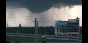
The Shawnee tornado is the most beautiful tornado I've seen because of the wicked vortices, but the Tulsa tornado on 3/31/17 was a little unique for me because they would come out of nowhere and have some hang time. Hopefully you'll see what I'm trying to say. Just left of the power pole it appears a few times.
Screenshot_20170904-222351.png
 
That's an idea for a horror movie. A person in an upper floor sees this horizontal vortex reach inside a window and start feeling around for a victim...
 
Back
Top