• While Stormtrack has discontinued its hosting of SpotterNetwork support on the forums, keep in mind that support for SpotterNetwork issues is available by emailing [email protected].

State of the Chase Season 2025

Been frustrating to watch the Southern High Plains go on a heater lately with subtle jet stream disturbance days that are nice if you live nearby or are out for an extended period of storm chasing while waiting idly by from the Midwest into the Northern Plains. I always regret sitting these periods out down there, but driving to the New Mexico/Texas border in June for subtle little 2-5% tornado days in the desert (that sometimes go BIG!) is about as enticing as it is for folks in Norman, OK to drive 10 hours to central Illinois in June to sit and babysit an outflow boundary (that sometimes go BIG!).

Looks like a bit of ridging builds into the Central U.S. this week which will mute severe weather potential some and allow for a pattern reset. The June 15-20 time frame (and beyond?) is starting to stand out as potentially active from the Northern Plains into the Great Lakes/Midwest.

There may be some early potential June 11-14 across the Northern High Plains into the Dakotas/Upper Midwest but a slow-moving cut-off low migrating from the Southern Plains into the Ohio Valley will probably stunt moisture return during this early period leaving things a little uncertain. June 15 and beyond however, it does appear we'll open the Gulf with a deep fetch of moisture into the Northern Plains accompanied by an active storm track rolling over the top of the ridge.

At base, looks like an active period for storm clusters and mesoscale-driven severe weather days (i.e. finally folks who live in Texas can debate whether they want to drive 10 hours north for an MCV and outflow boundary or not) but there's been some hints in global deterministic and ensemble models that one or two significant severe weather days could loom during this period if we get a bigger wave to eject. Way out there, but really seems like there's a signal for a bigger Dakotas - Upper Midwest severe weather day around June 18-19.

I wrote a bit more in a new blog post over here: SKYDRAMA.NET • Northern Plains - Midwest: Pattern Shift Could Open the Door to Repeated Severe Weather Mid-June
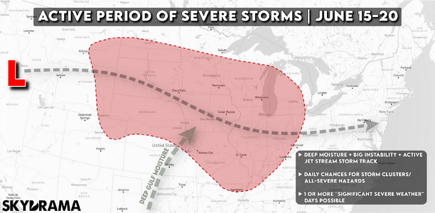
6-9-25-mid-june-pattern-2.png
 
Because of Work, I am pretty compelled to use natural segways, of holidays in May/June to augment and increase the PTO days to increase the total days available with the least impact to PTO hours. So, I can move to the right or left by a week on each side.. which puts me to end of may to second week in June.. I get 10 days. I study the long-term trends to give me the "best available" window, and it's not perfect, but over the past 5 years in this job, and how its worked out, for the years I could chase that is, and I chased Covid years which were the best because no one was out there hardly at the time. I've gotten 4 to 6 days of chaseable days out of 10... and to me, that's not terrible.

It looks like my window this year which starts 13 to 22, should, by all accounts, bring about 4 days ..maybe 5? the pattern across that period is still not totally defined with low level return flow, round a 500mb high location, so, while the JET favors mostly in Eastern Montana and the Dakotas, not totally sure how it will turn out yet. Historically I have chased these areas and have seen some magical views, but the road network in Montana isn't easy. The Dakotas are better and worse depending on how far west to east you are.

15-16 eastern Montana/ western ND
16-17 MN/WS but it looks frontal and linear, so I probably wont chase to wait for the following day back west.
17-18 northeast CO/ Western SD/NE
18-19 CO/NE ill defined, but has trended in this same area

19-22 models are too back and fourth between runs to really be reliable but the model trends between runs are dealing with the strength of the ridge trough across western US. some trends indicate a flattening of the pattern across the central northern US states.. which could change things but from what I saw it appears the trends show a return of Dakotas to Montana .. upper plains... too early to really be reliable, so I think things will hopefully make some isolated chaseable days once the finer parameters are resolved.

Either way, The balance of making the most of it by having secondary hobbies or site seeing that always make these trips worth it to me. Otherwise, why did I go? .. Chasing is basically going to Vegas; you know you're going to lose money no matter what you do, so make the most of the trip and let the rest go.
 
What a difference just a few days can make in the assessment of a chase trip, if not the whole season! OK maybe some recency bias combined with a fading memory of my chase vacations in the more-distant past, but Thursday 6/5 - Sunday 6/8 could my best four day stretch in more than a decade, in terms of the Venn diagram overlap of good setups + good execution + good luck (and let’s not fool ourselves, there is at least as much luck as there is skill involved in a successful chase).

Thursday 6/5 was the Morton tornado, including a great experience in the inflow region later in its life, closer to LBB, which was exhilarating even though the tornado was entirely hidden in dust and rain from our vantage point to its ENE.

Friday 6/6 was another exhilarating chase, only saw a brief spinup and a separate beautiful white funnel that did not touch down, but being close enough to the meso at times to feel that energy as it tightens up and a new tornado warning is issued, man there’s nothing like it in the world… Ended both these chases blasting far out ahead before dark to take in the awe-inspiring structure.

Saturday 6/7 was approached as a hybrid chase/repositioning day. Targeted Clayton NM and saw a fantastic downburst curling upwards as it spread out along the ground, then switched to a second tor-warned supercell to its west. No roads to approach it from the south, but it came to us as we waited, emerging from the haze to present a beautiful bell-shaped updraft and morphing later into a shrinking mothership as it weakened in the waning daylight. As it moved SE, we decided to stay with this one from the west instead, enjoying the sunlit back of the tower while driving on dirt roads that suddenly became little more than tire tracks through grass. This day was a real treat that itself made it worth extending the trip (I had originally been planning to go home on Sunday from DFW, which would have made Saturday a range-limited “lame duck day,” but decided to chase Sunday).

Sunday 6/8 was a bit of a disappointment compared to the forecast and my decision to delay returning home, although I never had high hopes after seeing things in the morning. It might have been better if we had targeted the northwest TX panhandle, but instead we targeted the southeast panhandle, at least in part biased in that direction for flights home out of DFW today. We did get on an HP beast starting from its very inception near Claude, but the Canyon made it hard to follow without a tremendous amount of driving and being at a distance from it. Still an interesting and enjoyable chase with some good long distance views over interesting terrain and finally getting under the meso near 7pm, just in time for a tornado warning and brief nearby spinup. And what can be better than chasing your way toward and near the airport you need to depart from?

In Wichita Falls and flying home from Dallas this evening, much happier than I was at this time last week. Feeling generally satisfied and fulfilled for the first time in many years. The past few years chasing with my son have been very gratifying, and looking through his eyes helped me appreciate things I had come to take for granted. Still, I was left with pangs of regret for execution errors, particular last year (missing Durango, failing to see the Midland tornado, even while on the storm, due to a stupid road choice). No regrets at all this year, as execution was quite good on this two-week trip (much better than my earlier 5/15-5/19 trip). Never perfect of course, but no regrets, other than maybe my target on Sunday, but I don’t think it was a poor choice by any measure other than hindsight. And in his fourth year chasing with me, I was finally able to give my son some higher-end chase experiences.
 
Last edited:
My smack talk last week seemed to accomplish the reverse jinx on a few subsequent setups. Yeah, that was the intent all along...

I was also out in the LBB area, and I agree that the Thu-Sun stretch has lifted the season into the average range... especially if you're easily able to chase the south end of the alley. It's pretty remarkable how anchored most chase-worthy activity this year has been to the TX PH and immediately surrounding area. The streakiness of chasing never ceases to amaze me across multiple domains, from personal success to geographic hotspots. I'm old enough to recall the TX PH having essentially nothing worth chasing year after year during the neverending drought of 2011-14. This year it just keeps coming back, even after multiple pattern resets.

Another streak I'm noticing is that the LBB-centered setups this year have been prolific with partially condensed, borderline bird fart type tornadoes. There have been a couple big boys in the mix like Matador on 4/24 and Morton on 6/5 (although even the latter was propped up visually by dirt to an extent). But mostly, we've seen somewhat high-based storms with large RFDs and broad low-level mesocyclones that track along boundaries with multiple short and less impressive spin-ups over an extended duration.

I'm happy with my personal season after seeing a couple respectable tornadoes amongst the aforementioned bird farts last week, capped off by possibly the best structure of my career Saturday in NM. I certainly have to take back my earlier complaint in this thread about structure on account of that storm alone. I still haven't scored a view of a tornado this year that gave me the kind of heart-pounding rush we're all really after, but that Amistad/Nara Visa storm finally delivered it.

It just so happens that the almost comical concentration of chase days in the TX PH region has worked pretty well for my home bias. Even for me, though, it sure would be nice to have at least a few more classic late season sloshing dryline opportunities centered on KS or S NE... so I can't imagine the frustration of people living well to the north trying to bide their time for "their" season. Those 35-kt southwest flow late season dryline setups for days on end in CO/KS/NE, to me, have always been the pinnacle of chasing. And the fact that precisely those setups are MIA almost every year recently is just a huge bummer, regardless of TX trying to pick up the slack.

Still keeping an eye on the pattern heading into next week. Hoping against hope that either a multi-day stretch of subtle opportunities, a single-day obvious setup with a high ceiling, or both can materialize over the northern half of the Plains. So much of the guidance slams cold fronts south ahead of any ejecting shortwaves with decent flow, though, leading to the type of upper-level charts I feel like we see endlessly every June now: lots of workable W to SW flow north of I-80 or I-90, an impressive LLJ south of I-80 or I-90, and zero overlap between the two. I remember complaining about this in 2018-19 when I first started working a full-time job and, finally having the funds, wanted to take a block of PTO for a N Plains chasecation in June. Fast forward 7 years, and that extended chasecation up there still hasn't happened (other than a giant dud in 2020 due to pandemic era boredom)... because June is usually dead, and the rare times it has come alive, it's been anomalously far south. But we shall see.
 
For chase vacationers and big dryline pattern chasers alike (I'm the latter), season quality always come down to the synergy of factors we can and can't control: how well the unresolved mesoscale realm cooperates with one's own make-or-break chase targeting/execution decisions. For me, it's been a pretty down year tornado-wise as neither of those two have intersected - I'll get one but not the other. None of my 8 resulting stat-padders are wall-hangers, and I don't have the true "shot of the year" in the bag yet. Grinnell was the sole treat, but soured by the fact it wiped out a big chunk of the town.

After 2024's bonanza, I'm not complaining at all. Seasons like this are just a part of this crazy thing, an inevitability of the law of averages when dealing with an activity of which results are not entirely in your control.

All of that said, my 2025 Plains season is likely done. Due to scheduling issues, big trips in the latter half of June are going to be more difficult for me to pull off this year - meaning my bar is going to be pretty high to justify the extra effort to make one happen. Maybe time for the season epilogue thread?
 
Last edited:
If I wouldn't have had stuff to do back on May 18th, I may have been tempted to go after that CO storm that started in Aurora (would have been a hour or so drive - which really is getting around as far as I'd want to go.)
But saying that, I remember I looked at SPC & stuff that morning, & was thinking storms would have fired farther north. But then that afternoon I looked to my east & saw the top of that storm. I took a break from the project I was working on to check radar, & sure enough it was tornado warned. Ofcourse I was thinking "dang I missed my chance there".

-------------------
Not specifically chasing, but for where I am...
I've certainly been satisfied/happy with the amount of rain we've been getting over the past couple weeks. And now everything is so lush & green due to it.
That said, I've been quite disappointed in the lack of lightning so far this year. but that said, it is only beginning of June (I just don't think it gets warm enough here late may/early june to do much - especially in the evening/after sunset)
...so now its "wait & see what 'monsoon season' " brings - that's usually better for lightning shows(the few we get here) than spring anyway. Not just monsoon, but in summer there's also what I like to call "the 9:00 special" ... I think its something about the local setup? maybe with the mountains & a wind-shift after sunset... thunderstorms tend to start firing around 9pm, which is perfect for viewing/videoing. I particularly like when that setup happens(have also found I can somewhat predict it just looking at the sky late evening). I just wish we got more lightning-storms here...but being semi-desert there just isn't much.. .lol,
 
Pretty sure I will be only doing local chases in southern CO and northern NM the rest of the season. I think after a fairly prolonged active period in this area, the severe weather season is winding down but the monsoon is coming, so there is that to look forward to. I had a lot of near misses this year, but despite missing the best tornado near Morton, I would still rate June 5 as a top-10 all-time day for me, maybe top 5. I will write up a full report as time permits, but started on the "wrong" storm near Portales and still got a decently photogenic tornado and maybe another one that was more of a birdfart on that storm, then later when I got the "right" storm got two tornadoes at the same time near Reese Center and others which may have been earlier versions of the larger Reese Center one or different ones. Eager to see ths damage survey on that storm! And that storm was amazing in so many other ways besides the tornadoes - one of the most intense I have ever seen, and one of the darkest skies considering it was still 2 hours before sunset - along with every kind of severe weather imaginable. Besides the tornadoes, there were gustnadoes, extreme winds, giant hail, wind-driven hail, and some pretty intense flash flooding - all of which I experienced in some way during the chase. So that one day brings my season up from very subpar to a bit above average. Actually I had a pretty good stretch last week, including a supercell induced mudflow/rockslide near home on Tuesday, nice LP structure in NM on Wednesday, the big day Thursday, and the supercell in the western OK Panhandle on Friday. I did not get a clear view of the brief tornado north of Griggs through the rain, and did not stay with it down into TX because I needed to be home Saturday, so missed the best structure, but still a decent chase day, capped off by blowing sirens and sheets of wind-driven rain in Boise City as a tornado passed a few miles northeast of town well after dark. With the amount of rain between me and the tornado and the risk of 4-inch hail, I did not try to chase it, and am not much of a night chaser, but the experience of watching the storm with the sirens blaring from under a gas station canopy (where I went to get my car out of the hail) was intense nonetheless. Luckily, the hail also narrowly missed town. On the way home Saturday as I went over Raton Pass I went right under what I think became the Amistad/Nara Visa storm. I knew that if I had tried to stay ahead of the storm instead of crossing under it I might get something good, but I needed to get home so kept going. Did get treated to some winter mixed precipitation coming over Wolf Creek Pass and stopped there for a while in hopes of "thunderslush," but the thunder did not come until later after I left. So all in all, a pretty eventful trip despite a few misfires and near misses.
 
Last edited:
Back
Top