Brett Roberts
EF5
Well, this seemingly too-good-to-be-true late May pattern a full month early might be trying to deliver the goods against all odds. Yesterday was an excellent Panhandle chase (on multiple storms/targets) that would've made everyone happy even during peak season, nevermind April. I was struck by how green the landscape looked relative to my expectations, at least in the eastern half of the TX PH... and each of the past few days has soaked additional areas that might've missed out prior. That should bode well for the next few days, and hopefully for later in May if we're lucky.
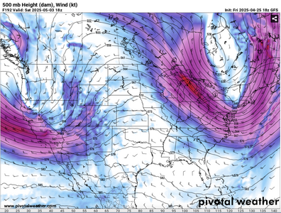
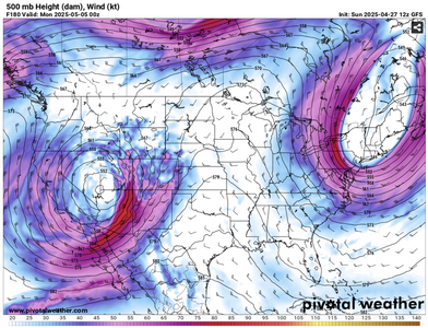
As of Friday morning, it appears Sunday 4/27 has support for dryline CI from about 60-70% of NWP guidance from various modeling centers. If we do get any robust storms to mature before dark, the environment looks supportive of tornadic supercells down a long stretch of the dryline from NE to TX. Overall, it resembles a high-potential day you'd typically see in mid-late May... coming on the heels of several subtler days in that vein. Then Monday should offer yet more tornado potential as the trough kicks out, albeit farther east and possibly messier with the positive tilt... but even so, this might be the most appealing stretch of consecutive chase opportunities I can ever remember seeing in April.
As of Friday morning, it appears Sunday 4/27 has support for dryline CI from about 60-70% of NWP guidance from various modeling centers. If we do get any robust storms to mature before dark, the environment looks supportive of tornadic supercells down a long stretch of the dryline from NE to TX. Overall, it resembles a high-potential day you'd typically see in mid-late May... coming on the heels of several subtler days in that vein. Then Monday should offer yet more tornado potential as the trough kicks out, albeit farther east and possibly messier with the positive tilt... but even so, this might be the most appealing stretch of consecutive chase opportunities I can ever remember seeing in April.