Silver Lining Tours vans rolled in Kansas

Status
Not open for further replies.
Skip, I would caution on assuming that everyone's interpretation of storm structure and evolution is so uniformly "obvious", even among veterans. I would also advise against what seemed to me to be a very scolding tone and an accusation that some (including Davies and me presumably) have ulterior motives is discussing counter-points. If you have reason to believe so, then please state them so we can talk about it.

As I pointed out before, we all ultimately have to learn these things on our own in the field independently. I have read and viewed most of the presentations you cited, and my understanding of the "bears cage" as it is loosely defined (as does presumably a large part of the chase community) was not the RFD itself, but the immediate region where the inflow and RFD are interfacing ("curling" around each other). The RFD can extend for many miles south, west and east of this location. The assertion that the entire RFD is now a 100% no-go region is equally baffling to me, as you put it, and seems a rather rash overreaction to El Reno. Is every supercell El Reno now? At least that is my takeaway here, if I'm misunderstanding you, then please accept my apologies.

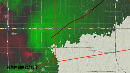
Secondly, the couplet was evident on Level 2 imagery, which is what is being used in your and other examples posted in this thread. On Level 3 imagery - such as what is pulled in GRLevel3 by chasers in the field - the couplet was not as apparent. That is an important distinction.

I feel like this discussion is devolving into a blame game, with some who have put themselves on a higher plane of storm knowledge insulting the intelligence of us more inferior types for "not knowing better" or worse, instead of an honest inquiry into what happened and learning from it.
 
Last edited:
Article seems to contradict position, wasn’t the meso supposedly to the north of the vans and they were trying to move south when they were hit? The article says the meso / tornado development was south of the vans.
 
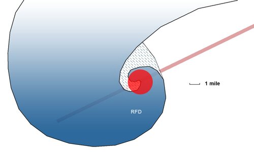
This has always been my conceptual model of a HP supercell.

supercell1.jpg

Dark Blue Area: RFD/rain
Hatched Blue Area: Inflow notch, may be partly or all rain-filled
Red Area: Mesocyclone/Bear's Cage
Light Red: Tornado Track

I have always been under the impression that RFD (blue area) south of the meso *should* be a region where a tornado would not normally be expected. Have I always been wrong? I'm open to that possibility. I'm really trying to understand the controversy here.

EDIT: Added area to depict partial or full rain wrapping, gradient added to take blue out of FFD.
 
Last edited:
Releases do not cover events where there is overwhelming proof of negligence. Negligence in civil law is defiend as follows: "Negligence refers to any failure to exercise reasonable care in one’s actions, resulting in injury or damage to another person or party. Negligence, the most common form of civil lawsuit, falls under the category of unintentional behavior, as opposed to intentional acts of harm."

For example: Acme Ultimate Spin Tours is **aware** that on big chase days, along lines of cars are possible near storms. They are also **aware** that long lines of cars could create a very dangerous situation. Acme drives towards a big storm with hundreds of vehicles clogging roads. Acme **decides** to join the caravan when they could have **avoided** it. An accident with injuries completely blocks the roadway in all directions. A secondary storm produces a violent tornado, preventing Acme's retreat. The twister hits Acme's van killing all 10 passengers.

No release is going to cover that situation.

This is NOT a direct comparison to the current situation as all the facts are not known. It does illustrate civil "negligence" when obvious hazards are known to exist and they are ignored. If a volleyball-sized hailstone is hurled 10 miles from the parent storm, hitting a tour van, one could argue it was a freak accident and did not involve an obvious risk.

Having said this, the obvious legal antidote is that participants should be aware of the dangers. The best example of accepted risk would be climbing Mt. Everest. The participants are well aware of the multitude of deadly events that can kill you from HAPE to avalanches.

Sorry i had to pause at volley ball hailstone...can you imagine if that was a real/common occurrence? This hobby of ours would be very different.
 
Perhaps my comment belongs in the recent thread about RFD/tornado causality, but.... It has for a long time been my observation based on earlier supercomputer simulations and eyeball observation, that there are two semi-independent processes contributing to what is called the RFD. The first is a downward propagation of vorticity from mid- and upper level dynamics, which tends to reveal itself as a clear slot due to adiabatic warming of the descending flow. The second is the addition of surface vorticity to the precipitation-generated downdraft and its transport around the mesocyclone axis base, which tends to reveal itself as a rain-wrap. Each process contributes to the initiation and maintenance of a tornado in varying degrees depending on the supercell structure. Disclaimer: I am not a meteorologist, but a dedicated amateur.
 
Article seems to contradict position, wasn’t the meso supposedly to the north of the vans and they were trying to move south when they were hit? The article says the meso / tornado development was south of the vans.

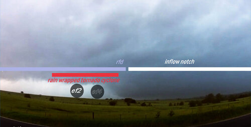
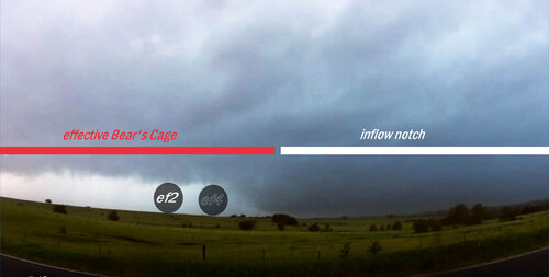
With a cyclic supercell the new meso will generally form to the northeast of the old occluding meso, and in some cases while a tornado is still in progress with the old occluding meso. As a result, you can end up with two separate mesocyclones at once, with the old meso trailing off into the RFD while the new meso begins to become the dominant circulation. In the case of the tour vans, they were hit by the EF2 tornado being produced by the old occluding meso that was approaching them from the Southwest while the new meso was spinning up to their north getting ready to put down the EF4. Here's a nice visual aid, ironically from the same day further west:

dxEwC97.jpg


My view is from almost directly east of the occluded meso/tornado and southeast of the new meso/tornado. This Supercell was a Classic Supercell so the whole process was quite visible and as such easy to position/plan for. In the case of the EF4 producing Supercell in Northeast Kansas though, that Supercell was fully HP and as a result that entire region where the occluding meso/tornado is located would be completely buried in rain filled RFD, rendering it invisible. So rather than either the meso being north or south of the tour vans, it was actually both.
 
Article seems to contradict position, wasn’t the meso supposedly to the north of the vans and they were trying to move south when they were hit? The article says the meso / tornado development was south of the vans.

It's consistent with the info I have. SLT stopped on highway 56 two miles east of Overbrook with the velocity couplet ~6-7 miles to their southwest, and held there for several minutes. This was about 35-25 minutes before impact. This is likely what the author is referring to as the parent supercell structure was visible here, including the midlevel rotation and long inflow tail feeding into the base. NWS Topeka noted the velocity couplet and this is what triggered the next tornado warning. After leaving this position, SLT didn't stop again until they were impacted.

One of the main takeaways in this, however, is that the part of the storm producing the tornadoes was never miles to the north.

19139
 
The above is what I find most baffling in all of this.
One of my comments was included here.
Comments in this thread where I use the acronym 'rfd', I'm referring to heavy outflow rain that cuts into the meso and wraps around the wall cloud or developing tornado in HP supercells. As the outflow wraps around on the outside of what is inflow feeding into the storm, the inflow creates a drier curling slot with less rain. The bears cage would be that area inside bounded by the rfd rain and hail. Of course it gets very messy and every storm is different and storms evolve rapidly. But evidently I should have made clear how I defined these terms and how I thought they have been historically used in the chase community. Maybe this is intentional or maybe there is genuine confusion about this. In talking about rfd I would say a person would drive through the rfd rain core to get into or out of the cage. I'm thinking surely this was clear from my comments. You use 'rfd' or 'rfd core' to mean the whole rfd bounded region, all the rain and everything inside, it seems.
 
I do appreciate some of the clarification @Skip Talbot, as the video I made and graphics were based heavily upon Jon Davies' analysis before your follow-up. I am willing to learn, especially from this case.

Has SLT learned from this? Only time will tell.
 
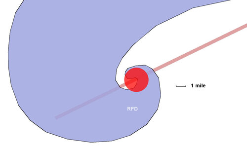
This has always been my conceptual model of a HP supercell.

Blue: RFD/rain
Red: Mesocyclone/Bear's Cage
Light Red: tornado track

I have always been under the impression that RFD (blue area) south of the meso *should* be a region where a tornado would not normally be expected. Have I always been wrong? I'm open to that possibility. I'm really trying to understand the controversy here.

Supercell morphologies exist on a continuum, so your particular drawing is not necessarily wrong, but it ignores the variability in HP structures. A large fraction of HP supercells have rain completely enclosing the meso/tornado, so you need to fill in a big chunk of white north and west of the big red dot in blue.
 
Jeff, you are correct - I added that to the graphic. The diagram also does not depict a handoff situation, which would place another dissipating tornado on a more southerly track. This, as I've previously assumed, would have a very clear couplet even on Level 3 radar to alert a chaser to the tornado's presence. The main lesson I see with this situation is that we can indeed have a tornado there without a clearly-evident radar signature. I assert that this convergence of factors truly is a rare situation, and dare I say, without precedent in storm chasing. We've seen handoffs. We've seen rain-wrapped tornadoes. We've seen weak tornadoes with ambiguous radar signatures. We haven't seen strong tornadoes in RFD that never had a clear couplet. Someone can prove me wrong, I'd gladly retract that statement with supporting evidence.
 
Last edited:
19145
Blue: RFD/rain
Red: Mesocyclone/Bear's Cage
Light Red: tornado track

I have always been under the impression that RFD (blue area) south of the meso *should* be a region where a tornado would not normally be expected. Have I always been wrong? I'm open to that possibility. I'm really trying to understand the controversy here.

This model is totally fine, Dan. There are other configurations and Jeff makes a great point about variability, but even this storm is consistent with the above model.

19143

The tornadoes are in pretty much textbook locations: the top/north side of the curling RFD. It totally jives with your drawing. They were not "miles south" of the mesocyclone. This is what SLT staff stated initially, and I think many are still assuming this was the case. The video and radar show otherwise.


There's an important caveat here, however. I think the above model works great for a classic supercell, in which you actually have visibility under the rear flank. In the above annotated photo, you can't actually see the bounds between the red and blue regions. On a classic, there's a clear slot and then spiraling rain bands. On an HP, there's simply RFD core. So what should you do? Assume this whole region is blue? I think you should assume the whole region is red. The RFD core on an HP harbors the tornado. The RFD gust front is the Bear's Cage on an HP. Anyone behind this red line could be impacted by tornadic winds without warning. You have no situational awareness once you are behind the red line. I'd hope this is a safety tip from the storm chasing 101 course because it's extremely important for all chasers to know this. If folks don't, we really need to drive it home.

19144


I would also advise against what seemed to me to be a very scolding tone
I'm trying to be direct and concise. Folks are getting hurt and killed out there, and I'm far more concerned about that than I am about offending people.

accusation that some (including Davies and me presumably) have ulterior motives is discussing counter-points. If you have reason to believe so, then please state them so we can talk about it.

I value your openness and honesty in this discussion, Dan. That line wasn't directed at you, and I left it intentionally vague because I didn't want to dive down that hole. I think it's far more important that we simply stick to what went wrong and how it can be avoided in the future.

There's misinformation that's going around and I think it's important to correct it because it has the potential to do further damage. Others have already made accusations as to why this misinformation is going around, but I don't want to speculate. I think there are lots of reasons.

Is every supercell El Reno now?

No, every storm is not El Reno. But nearly every year there's a mile+ wide tornado inside of an HP RFD core that is even larger still. These storms need to be treated with extreme respect or future injuries and fatalities will be inevitable.

The Bear's Cage on a large HP supercell, that big green circular region, can span miles. When the storm is warned for tornadoes, you should assume there is a tornado inside of it. When you punch that Bear's Cage blind, you are playing Russian Roulette.

Secondly, the couplet was evident on Level 2 imagery, which is what is being used in your and other examples posted in this thread. On Level 3 imagery - such as what is pulled in GRLevel3 by chasers in the field - the couplet was not as apparent.

The radar is important for illustrating how this event unfolded. An important point in a discussion on chaser safety, which will be part of this video analysis, is that chasers should not rely on the radar data for their safety, but should instead be using storm structure visuals. The radar data is old, coarse, tilted, and not indicative of what's happening at ground level, making it prime for misinterpretation. However, this storm did provide ample visuals. When chasers don't have those visuals, they've lost situational awareness.
 
Skip, so as I understand it, the main issue in question wasn't whether a transect through the RFD south of the meso is or isn't a safe move, it is where the vans were relative to the storm's primary meso (south of the meso or in its path). The argument you're making I presume is that visual storm structure indicated they drove directly into the meso, not that they encountered a unusual tornado *far* south in the RFD that they should have expected to be there? The latter assumption is what I've been basing pretty much every post I've made so far in this thread on.
 
Last edited:
Status
Not open for further replies.
Back
Top