Silver Lining Tours vans rolled in Kansas

Status
Not open for further replies.
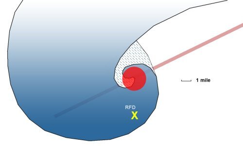
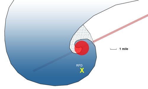
My impression (and likely Jon Davies and others') is that the vans were struck at/near this position in the storm:
supercell1c.jpg

Radar seemed to support that version of events. You can see then why those of us, including me, were arguing "that doesn't make any sense" when some were saying "it's obvious that is a dangerous spot and they should have known better".

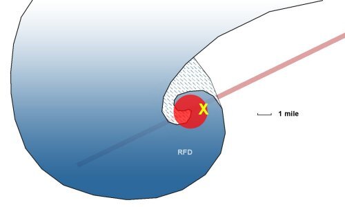
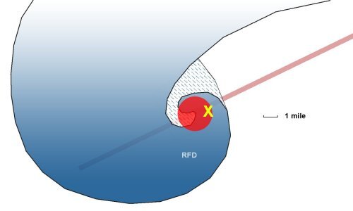
When in actuality, (if I'm understanding Skip's data correctly), storm structure indicated that their position may have been more like this just before they were struck:


supercell1b.jpg

That being a dangerous spot I can agree on without question. Skip, do you think that might account for the differences in opinion we're seeing?
 
Last edited:
The argument you're making I presume is that visual storm structure indicated they drove directly into the meso, not that they encountered a unusual tornado *far* south in the RFD that they should have expected to be there?

Yes. Sorry if I've been talking past people or using a weird dialect of storm chaser surfer slang.

Just to be clear: Unlike initial claims, the impacting EF2 was not an unusual tornado that occurred far south in the RFD. It wasn't a satellite, or an unpredictable, unavoidable fluke. It was for the most part, and as far as I can tell, a typical HP tornado that tracked with the mesocyclone. The story told by the visual structure directly contradicts the story SLT has told.
 
When in actuality, (if I'm understanding Skip's data correctly), storm structure indicated that their position may have been more like this just before they were struck:


View attachment 19147

That being a dangerous spot I can agree on without question. Skip, do you think that might account for the differences in opinion we're seeing?

That's correct. The RFD curling around at the top end of the RFD gust front is the most dangerous part of the storm, and that's where the impacting tornado was.

It should be mentioned, however that the RFD section to the south is no joke on a massive HP on a volatile setup like this. Often times you simply can't tell the difference between RFD and tornado once you're behind the RFD gust front. It's just wind and rain. Tornadoes are indeed possible in the straight line RFD surge. Allan Gwyn has a great shot of one trailing the El Reno tornado in the RFD surge, a mile or two west-southwest of the wedge. Satellites are of course possible all around the rim of the RFD gust front and rain wrapped tornado cyclone. Anticyclonic tornadoes on the southern end. Even multiple ongoing tornadoes from other cycles. The Waldo/Tipton storm from the same day had three concurrent circulations going at one point. Thinking about chasing that storm from behind the RFD gust front, but instead it being totally rain wrapped, curdles my blood.

I think that circular ball of RFD core (the red circle), and even the bulk of the bowing and surging RFD gust front, should be treated as if it is a tornado, not that it might just have a tornado inside of it. Maybe that's too conservative for some folks. I can't tell you how to chase. I can make recommendations on how to minimize your risks while still getting the most out of your chase. But the chaser elects to take on their own level of risk and should be responsible for its consequences.
 
I'm not sure if I've just always thought of it differently or meaning has sort of changed over time, but everything I've said on this topic concerning safety, risks, most all of it, can be pretty much disregarded, understanding now what others mean when they say "rfd core" or talk about rfd on an HP storm. I agree you should never drive through or drive across or into "rfd core" if you want to avoid risks. That is very risky. When I was talking about driving through rfd, I was meaning if you knew where the bear was and you were somewhere in or near the cage and then drove through the rfd to get out. This would be as rfd and rain was surging around and becoming more and more pronounced. That is what "surging" meant to me. I was talking as if you were already in the rain and rfd area as the storm was becoming more HP and you wanted to leave. I totally understand now why people were becoming upset at my comments, and it also explains why I could not figure out why others were saying driving east was better. The discussion takes on new meaning. Sorry for my part in the confusion, sure wish I could have figured it out sooner. I could explain some other misconceptions I had but will leave it at that for now. I feel silly all the energy I've spent processing on this.
 
I think a good rule of thumb that I would have otherwise thought was pretty obvious but apparently isn't is that it's a really bad idea to drive into a precip-laden RFD in general, but especially when there is enough precip to obscure vision to the other side.

You can't chase what you can't see.
 
I think it might be beneficial to recap this thread for those who may be reading it from the start, as the plot has been hard to follow. The important point is that we have two scenarios or positions being discussed simultanously and being confused with each other. One I'll refer to as Scenario A and the other Scenario B.

1.) Radar imagery and tornado damage paths initially supported Scenario A, which was a classic tornado handoff with the old (EF2) tornado southwest of the vans' locations deep into the HP RFD, and a new large circulation developing to the north of the vans' position (that would soon produce the EF4). The vans proceeded south and were enveloped by the RFD precip while the new circulation intensified to their north. The old tornado (EF2) did not have a clear couplet on Level 3 radar, leading to the impacted group failing to detect it before driving into it. The vans' impact location within the storm in Scenario A was assumed to be well south of the main meso, a mile or two south into the RFD where one would expect strong crosswinds and possibly hail, but where one would not normally anticipate a strong tornado - particularly in the abscence of a clear velocity couplet on radar.

Scenario A had the vans impacted in this general location of the storm:

supercell1c.jpg


2.) In a more detailed investigation of video and photo imagery by Skip, Quincy and others, Scenario B emerged that suggested the vans were impacted within the primary mesocyclone of the storm. This was derived from level 2 radar, the storm structure visible in videos from chasers in the area as well as tour guests, and the timeline of events. Scenario B places the vans' impact location in this part of the storm:

supercell1b.jpg

3.) Up until Page 12 in this thread, the two scenarios have been confused in discussions. Those defending the vans' position are actually referencing the Scenario A position, those criticizing it have been referring to the Scenario B position. Opinions in the chase community differ on whether or not the Scenario A position is acceptable for a tour group. *Everyone* agrees that the Scenario B position is dangerous.
 
Last edited:
Between all the radar images, known location of the roll over, witnesses reporting their position, etc., I'm missing something here as to why their exact location in relation to the primary meso is argued? Is it because we are only dealing with a 1 or 2 mile difference? Sorry if I overlooked something.
 
Last edited:
I think a good rule of thumb that I would have otherwise thought was pretty obvious but apparently isn't is that it's a really bad idea to drive into a precip-laden RFD in general, but especially when there is enough precip to obscure vision to the other side.

You can't chase what you can't see.

Most of us while maneuvering around the storm got hit by that strong and large area of RFD along 59. It was the “safe” place to be at that time I felt even with the tornado crossing in front of us by about ½ mile. At that time there really wasn’t much more anyone could do but the location of the EF4 was obvious at that point. I knew what was coming fast and was prepared for the RFD but it looks like other hazards could have also been coming from these posts. Noted for the future ….

How fast was this storm moving?
 
Found another article related to it. This a tour guest from Santa Barbara California.

Santa Barbara Storm Chaser Recounts a Close Call

The lady's story is damning IMO ... they kept changing position to be in FRONT of the RAIN WRAPPED "turbulence"? This is definitely a positioning issue ...

"Hill predicted a large tornado and spotted the beginnings of one, a mesocyclone, to the south of our vans. We kept changing position to be in front of the turbulence and to watch the tornado formation. Heavy rain made spotting difficult."
 
@Skip Talbot Thanks for the posts and I cannot wait for the video that should help us all understand this day and keep us more aware in these situations. Hopefully my submissions are not a bad example lol.
 
I'm interested in Skip's video because maybe it will finally confirm (for the confused) what the rest of us already figured out from the beginning. The tour should have never been there to begin with.

A lot of arguments/ defenses are being made from the viewpoint that chasing is inherently dangerous, which it is not. Severe storm observation and documentation is not dangerous at all beyond typical driving/road hazards and lightning. Dangers from high winds, hail, tornadoes and accidents near storms are all manufactured hazards created by chasers. It annoys the hell out of me when people shrug their shoulders after something bad happens and say "Welp, chasing IS dangerous."

No. No it's not. CHASERS are dangerous.
 
The lady's story is damning IMO ... they kept changing position to be in FRONT of the RAIN WRAPPED "turbulence"? This is definitely a positioning issue ...

"Hill predicted a large tornado and spotted the beginnings of one, a mesocyclone, to the south of our vans. We kept changing position to be in front of the turbulence and to watch the tornado formation. Heavy rain made spotting difficult."

Yes that what I was alluding to when I posted in response to Ben’s posting of the article - I believe Roger’s original FB post about the incident - or maybe it was Jon Davies or someone else, I’m not sure - said the meso was to their northwest and they were heading south (“Scenario A” in Dan’s post). But this lady’s account says the meso was south (“Scenario B” in Dan’s post) and I guess has them heading toward it.
 
Last edited:
Status
Not open for further replies.
Back
Top