Silver Lining Tours vans rolled in Kansas

Status
Not open for further replies.
"he was completely oblivious to the only storm in the area with a history of TOR warnings and funnels on the ground."

If you wish to make that charge against Roger, you also need to make it against the SGF NWS and JLN emergency management along with every meteorologist on Joplin TV that day. It is hard to imagine how screwed up the NWS's output was that afternoon. That was a major cause of the tornado causing the highest number of deaths from a single tornado since the warning system began. It caught most everyone by surprise.

Watch this video from KSNF TV:
and, listen closely. Their meteorologist and anchor were covering the tornado, which was supposed to go N of JLN based on the NWS TOR. Note their tone is rather blasé even though the tornado is on their air and is moving into the city. When I interviewed Caitlin for my book, it didn't occur to her (even though she is a degreed meteorologist) at that point that the tornado was moving into the city. Suddenly, when Caitlin realizes what she is seeing, her tone completely changes. [Note, the tower and camera are north of JLN which allowed it to view the tornado even though people along tornado's path could not see it.]

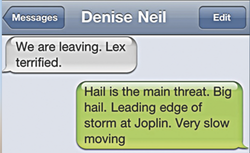
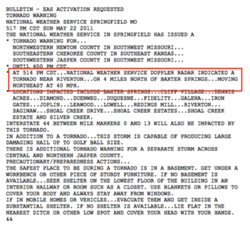
The NWS TOR for JLN, and subsequent statements, said the tornado was moving northeast (see nearby warning). The parent storm was a right-mover that was moving nearly straight east. Look at map of the area. A tornado over Galena, moving northeast, doesn't come anywhere near JLN. The NWS even mistook the debris ball for hail and put out a SWS saying it was the primary threat! The screen capture nearby is from one of the survivors who was mislead by that statement into letting down her guard.

While I do not want to get into what Roger may or may not have done well, the NWS completely screwed up this event which is not trivial when evaluating the totality of events of May 22, 2011.
 

Attachments

  • Screen Shot 2021-03-11 at 6.02.19 PM.png
    Screen Shot 2021-03-11 at 6.02.19 PM.png
    496 KB · Views: 1
  • 517 TOR.png
    517 TOR.png
    973.6 KB · Views: 1
Last edited by a moderator:
While I do not want to get into what Roger may or may not have done well, the NWS completely screwed up this event which is not trivial when evaluating the totality of events of May 22, 2011.

The point of this thread and what it has evolved into is to literally discuss what chasers may or may not have done well, what to learn from it, and how to be safe. Not to drag NWS forecasters or other meteorologists through the mud and make them out to be a bunch of mouth breathers. For those interested, here's the tornado warning for Joplin from that event, as well as its updates (SWS) that correct for storm motion by the first SWS at 5:30pm CDT. I'm not sure where in that tornado warning there's reference to hail being the main threat, as by definition, a tornado warning and any SWS on a tornado warning implies a tornado is the main threat.

Bringing it back to chasing, lets go ahead and say that in the worst case scenario, there's no warning at all. As a chaser, one needs to be proficient at understanding radar signatures in potentially tornadic storms, have good situational awareness (geographically and atmospherically speaking), and more that has been discussed at length in recent posts to this thread. Any chaser going out to chase is solely responsible for their wellbeing and safety when out there. If you're in front of a storm waiting on a warning to tell you the storm is capable of producing a tornado or is producing a tornado, what direction/speed it's moving in, etc., you're one bad tech-glitch, data lag, etc. from getting rolled off the road. That is a general statement, and not directed at any of the incidents discussed in this thread.
 
Regarding the NWS, the warning in Mike's attachment mentions Joplin and I-44 from mile 0 to 13 as being locations in the path of the tornado. So even if they had the motion wrong at that point, it did say Joplin and I-44 were in the path, so perhaps not rising to the level of a complete screw up.
 
Regarding the NWS, the warning in Mike's attachment mentions Joplin and I-44 from mile 0 to 13 as being locations in the path of the tornado. So even if they had the motion wrong at that point, it did say Joplin and I-44 were in the path, so perhaps not rising to the level of a complete screw up.
No one knows where the mileposts are. Everyone in Joplin knows where Galena is. If you tell people the tornado is over Galena and moving northeast, they conclude that Joplin is not threatened.
 
I'm not sure where in that tornado warning there's reference to hail being the main threat, as by definition, a tornado warning and any SWS on a tornado warning implies a tornado is the main threat.

Screen Shot 2021-03-12 at 8.48.16 AM.pngHi Alex, here is the reference to large hail. This was due to mistaking the high reflectivity associated with debris for hail. Of course, this was before dual polarization. It was in the 5:39pm SVS. The tornado crossed the west city limit boundary at 5:41.
 
The NWS TOR for JLN, and subsequent statements, said the tornado was moving northeast

... the NWS completely screwed up this event

What the NWS actually said:

NATIONAL WEATHER SERVICE SPRINGFIELD MO
128 PM CDT SUN MAY 22 2011

THE NATIONAL WEATHER SERVICE HAS ISSUED TORNADO WATCH 325 IN
EFFECT UNTIL 9 PM CDT THIS EVENING

THIS INCLUDES THE CITIES OF...[...] ...JOPLIN

TORNADO WARNING
NATIONAL WEATHER SERVICE SPRINGFIELD MO
517 PM CDT SUN MAY 22 2011

* AT 514 PM CDT...NATIONAL WEATHER SERVICE DOPPLER RADAR INDICATED A
TORNADO NEAR RIVERTON...OR 4 MILES NORTH OF BAXTER SPRINGS...MOVING
NORTHEAST AT 40 MPH.

* LOCATIONS IMPACTED INCLUDE [...]
...JOPLIN

SEVERE WEATHER STATEMENT
NATIONAL WEATHER SERVICE SPRINGFIELD MO
530 PM CDT SUN MAY 22 2011

A TORNADO WARNING REMAINS IN EFFECT

AT 524 PM CDT...NATIONAL WEATHER SERVICE DOPPLER RADAR CONTINUED TO
INDICATE A TORNADO NEAR RIVERTON...OR NEAR GALENA...MOVING EAST AT 20
MPH.

LOCATIONS IMPACTED INCLUDE [...]
...JOPLIN

SEVERE WEATHER STATEMENT
NATIONAL WEATHER SERVICE SPRINGFIELD MO
539 PM CDT SUN MAY 22 2011

A TORNADO WARNING REMAINS IN EFFECT

AT 534 PM CDT...TRAINED WEATHER SPOTTERS REPORTED A TORNADO NEAR
GALENA...MOVING EAST AT 25 MPH. THIS STORM IS MOVING INTO THE CITY
OF JOPLIN.


LOCATIONS IMPACTED INCLUDE [...]
...JOPLIN

TORNADO WARNING
NATIONAL WEATHER SERVICE SPRINGFIELD MO
548 PM CDT SUN MAY 22 2011

* AT 543 PM CDT...TRAINED WEATHER SPOTTERS REPORTED A TORNADO NEAR
EASTERN JOPLIN
...OR 9 MILES EAST OF GALENA...MOVING EAST AT 45 MPH.
DAMAGING AND MULTIPLE VORTEX TORNADO WAS REPORTED WITH THIS STORM

LOCATIONS IMPACTED INCLUDE [...]
...JOPLIN

What the NWS did not say:
* Only locations northeast of Galena will be affected
* The tornado will always move northeast
* No other tornadoes will occur in the warned area
* The tornado will miss Joplin to the North
* Hail is the primary threat with this storm
 
I'm here to correct misinformation. Not help you peddle your book.

I sensed that, Skip. That is why I suggested you borrow the book from a library so I would not accrue any royalties from you.

There is no misinformation in the story of the tornado moving into Joplin. It is a story of tragedy. Perhaps it would help to read the book (it is just 66 pages) before judging its quality.
 
Status
Not open for further replies.
Back
Top