Hurricane Matthew Official Thread

Did you guys see the latest pressure drop at 8:00 PM / EDT

934 MB ¥ dropping

Total diameter increase in storm size on all 4 quadrants...

Sent from my iPhone using Stormtrack mobile app
 
Google image searches show the type of structures in the areas that are likely to see some of the most intense parts of Matthew. Looking at satellite images, it doesn't look like there are any dense population centers in that part of the country, thankfully. The flooding impacts to the east may be the bigger threat.

Tiburon, Haiti:
https://www.google.com/search?q=tib...-b_PAhXH8YMKHZNiBDUQ_AUICSgC&biw=1920&bih=971

Plansinte, Haiti:
https://www.google.com/search?q=tib...ih=971#safe=strict&tbm=isch&q=plansinte+haiti

Carrefour Gros Chaudiere, Haiti
https://www.google.com/search?q=tib...ict&tbm=isch&q=carrefour+gros+chaudiere+haiti
 
Looking at the latest IR satellite image of Matthew....... not good news for Haiti. I feel for those poor people. My understanding is that a lot of the trees have been cut for fuel in the higher elevations -- with 25 to 40 inches of rain possible.
 
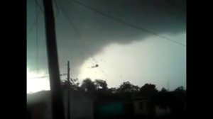
Hurricane Matthew Tornados / Waterspout video and still images...


Jamaica waterspout off east coast...

e0e5370665f9f436133fe46238b33584.jpgdc0dbffc5f375ba53f4b05b87e97d0e4.jpg

af777fe4d52c53411cf29fd4ea6159c5.jpgae952a1e6f3f45da922f92820ff7a153.jpg

Tornado touch down in Dominican Republic...

Sent from my iPhone using Stormtrack mobile app
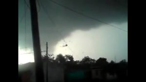
 
Haiti Storm Surge and Landfall of Hurricane Matthew 7:10 AM / EDT - October 4, 2016


Sent from my iPhone using Stormtrack mobile app
 
@Warren Faidley - We have asked for it to stop and it has not therefore we will make official warning for the large images.
@Ryan Toemmes - Large imagery used in future posts will be deleted. Please refer to my message to you on Monday.
@rdale Your only contribution to this thread is snark. Don't be a dick.

Thank you, everyone. Carry on.
 
12Z GFS brings the center of circulation across the shore just south of Vero Beach and tracks along the coast until King's Bay, GA.

This put the dirty side onshore with attendant storm surge with low tide at landfall. If this tracks like the 12Z up through the Space then Palm Coast to GA, major flooding, wind damage, and wide spread power outages are assured.

Run to run both the ECMWF and GFS have bought the center of circulation westward since Sunday.

At 120 hrs, the ridge to the east brings Matthew back down south as recurvature from the E CONUS trough does not occur.

Maybe a Round Two?

Craig KV5E
 
Of additional interest is that after taking Matthew up towards the Georgia coast, the new run continues to send Matthew back south and the southwest as some earlier GFS and Euro runs have done. However, instead of turning Matthew back out to sea eventually, the new run takes a vastly weaker Matthew across Florida and into the Gulf by Tuesday next week, with it then meandering in the eastern Gulf. The GFS has it very weak at that time, at only tropical depression strength. This is similar to what the Euro run did midday yesterday.
 
Understood Steve...

Awaiting Hurricane Matthew's arrival...

Locked down all set and ready to go...

For anyone who is interested and located outside of our general area...

http://www.local10.com

Live Storm Feed coverage will be posted...

I won't post any pics while running live...

TWC crews are here in town doing interviews...

Full Dade, Broward, and Palm Beach County coverage on Hurricane Matthews arrival...


Sent from my iPhone using Stormtrack mobile app
 
Last edited by a moderator:
I have the time available, and I felt a little bit of an impulse to head out and chase this one, but decided against it. Not an ideal storm to chase IMO. If the NHC track holds true, you'd get the western eyewall (and a shot at an inside-the-eye experience if a slight westerly shift happens), but either way, the stronger side of the storm will remain offshore. A shift of the track to the west will take the storm farther inland, in which case it could weaken substantially. An eastern track shift could easily take it too far offshore to get the eyewall. As strong of a storm Matthew is likely to be, I'd prefer a more right-angle approach to ensure a landfall at peak intensity and a better chance of adjusting my intercept location successfully.
 
@Ryan Toemmes, what's the feeling you get about residents actually taking action and evacuating? I am assuming you're still in Florida, right? General sense of the situation?
 
I'm still here Steve...

People here are nervous and watching in anticipation for the arrival of Matthew...

I'm staying on site at my company warehouse in Fort Lauderdale Florida...

Residents north of Deerfield Beach Florida up thru Daytona Beach Florida have been urged / told to evacuate on the east side of the intercoastal waterway - Barrier Islands -

All draw bridges on lock down as of 12:00 AM late last night to allow full evacuations this morning...

Evacuations aren't mandatory but authorities are telling all Oceanside residences to leave Palm Beach County on up the coast line...

Authorities have made it clear on all broadcasts that when winds exceed 40 MPH absolutely no Emergency personal will assist or respond to EMS calls....

We will head north on interstate 95 after the storm makes land-fall...

Hurricane Matthew is expected to expand and increase intensity a little more as its passes thru the Gulf-Stream Waters of the Atlantic Ocean NW of Andros Island Bahamas...


Sent from my iPhone using Stormtrack mobile app
 
Back
Top