Hurricane Matthew Official Thread

11:00 AM update...

FDLE / Governor's Office

6:00 PM curfew in effect now for the entire east coast region under Hurricane Warning...

The NE eye wall has increased in intensity... Pressure is dropping according to Hurricane Hunter Aircraft now at flight level inside the eye of Matthew...

The Local Doppler radar in Miami shows the eye wall approaching Western Bahamas Andros Island north tip...

Check on Doppler Radar status every few hours and watch the progress of Hurricane Matthew make land fall on Florida's East Coast...

Max Tracker Doppler Radar on Goggle Earth...

Download the APP and watch Matthew on HD...

Wind gusts of 45 miles per hour now felt in my area...

Hurricane Matthew Now Cat 4 Storm once again plowing thru the Western Bahamas...

Sent from my iPhone using Stormtrack mobile app
 
Last edited by a moderator:
The strong-side eyewall passed basically right over the MYNN airport. The METAR gusted to 74kt and then stopped reporting, so the max wind was probably not sampled.
 
It's highly possible Hurricane Matthew could once again increase to Category 5 strength by 8:00 PM tonight once the storm passes over the Gulf Stream Waters of Floridas east coast...

There is a saying here in South Florida...

The Gulf Stream Waters hold another level in category of strength to these storms...

Stay Tuned...

Current Stats...

940 MB pressure ¥ Dropping fast...

http://www.earthcam.com

Sent from my iPhone using Stormtrack mobile app
 
Last edited by a moderator:
The eyewall has now been showing lightning strikes for the last hour or so. This joins Rita and Katrina from last decade as the only ones I remember seeing this behavior in.
 
I just heard from BIL in Savannah. They were going to stay put, but a mandatory evacuation was just called. They live in the city proper, not on one of the islands.
 
Just received Tornado Warning [emoji615]️

Feeder Bands now impacting the coastline of Palm Beach County, Broward County and Miami Dade County...

Weather Radar indicating rotation...

Sent from my iPhone using Stormtrack mobile app
 
Last edited by a moderator:
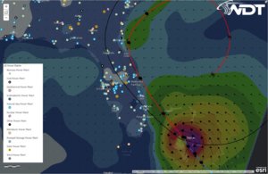
One of our guys here at WDT put some layers on a map... Power plants with hurricane Matthew track. Feel free to lift and use.
PowerPlantsAndMatthew-20161006-1620Z.JPG
 
The loop on the future tracking of this storm has many people talking down here...

Many future forecast models indicate this motion to occur in the next 48 hours...

Hurricane Jean in 2004 was the only known storm that actually looped around and hit the Florida coast line twice...

Second heavy rain band from Hurricane Matthew approaching the Florida coastline... Winds here still gusting 30 - 45 knots at times...

Power outages already being reported from the gusty winds...

Storm center appears to be jogging a little more northward from us...

75 - 85 knot Lower end Hurricane force winds expected near 8:00 PM / EDT near our location...


Sent from my iPhone using Stormtrack mobile app
 
Last edited by a moderator:
FPL - Florida Power Light -

Reporting 12,000 + customers with power outages in clusters...

This usually happens in our area with-in neighborhoods with above ground power lines that come in contact with trees...

Listening to scanner feed traffic from the Broward Sheriff's Office with Broward Emergency Management...

Winds Gusty now over 50 MPH in short bursts with passing feeder bands...


Sent from my iPhone using Stormtrack mobile app
 
The eye wall of Hurricane Matthew is directly east of us by 92 Nautical Miles...

Fort Lauderdale is 26.2 latitude. Hurricane Matthew at 4:00PM was 26.00 lat

FPL reports 20,000 + residents with-out power in the tri-county area as of 4:00 PM EDT

Freeport Bahamas will be under the gun of Hurricane Matthews NE powerful eye wall by 6:00 PM / EDT

Weather station on site at Freeport Cruise Port...


Sent from my iPhone using Stormtrack mobile app
 
Back
Top