• While Stormtrack has discontinued its hosting of SpotterNetwork support on the forums, keep in mind that support for SpotterNetwork issues is available by emailing [email protected].

Hurricane Matthew Official Thread

Steve Miller

Owner Emeritus
Staff member
Supporter
Joined
Jun 14, 2004
Messages
1,787
Location
Moore, OK
2016-09-28_11-32-32.png
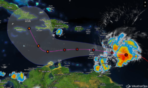
The Hurricane Hunters investigating 97L, the strong tropical wave now moving through the Windward Islands, found that it now has a closed circulation and is stronger, so it is now Tropical Storm Matthew with winds of 60 mph. Tropical storm conditions are likely today for many of the islands in the Lesser Antilles as Matthew moves through. Strengthening is forecast during the next few days and Matthew is expected to become a hurricane. In the near term the track forecast for Matthew is straightforward: continuing on toward the west-northwest or west into the Caribbean while gradually slowing down. Toward the weekend the uncertainty grows. Most models have Matthew making a sharp turn toward the north and moving toward Jamaica, eastern Cuba, and then the Bahamas. If it were to take this course Matthew could also go on to affect parts of the U.S. East Coast and Atlantic Canada next week. However, even though model agreement is good, a track more into the western Caribbean or perhaps even the Gulf of Mexico cannot quite be ruled out yet.
2016-09-28_09-25-35.png
 
a track more into the western Caribbean or perhaps even the Gulf of Mexico cannot quite be ruled out yet.

Agreed. There is a slight chance that the storm "misses its turn" so to speak, although odds are its going north. This one has me pretty interested... there have not been too many model runs lately that don't significantly strengthen this storm.
 
We quietly introduced a new radar viewer over the past week. If you haven't checked it out, here ya go: http://stormtrack.org/imap - or you can click "iMap" in the menu above.
I just positioned the view to be optimal for TS Matthew. Give it a view and message me if you have ideas or concerns.

Now let's get this thread going! This one could get interesting.
 
I do believe we have ourselves a hurricane, gentlemen. So which way does it go?

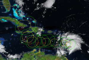
Euro - Paths anywhere from Yucatan>S Texas all the way to Bermuda. It's a mess of spaghetti.
GFS - Several historical similarities represented by ensemble paths: Hugo, Sandy, Bob, Donna?

GFS and a couple other models take this up to a Borderline Cat 3/4 off the SE coast pretty consistently. Landfall likely as a weak Cat 3 or Strong Cat 2 along the mid-Atlantic and the booking NNE into New England Whilst maintaining Cat 1 wind speeds until Maine.

All of this is a moot point, of course, if the trough picks Matthew up and throws it east faster than the models predict. That being said, we could see a major issue along the east coast in about a week. How do Hurricanes impact elections?
 
I'm hoping we don't have a carbon copy of Hurricane Charlie 2004...

The future computer model forecasting has been everywhere on this storm because of the variables in the Caribbean Sea & Gulf of Mexico...

The timing of the Trough pushing east is key on this storm turning north...

Elections...

No impact here... Miami just shrugs it off...


Sent from my iPhone using Stormtrack mobile app
 
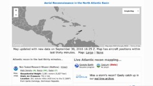
P3 Orion Hurricane Hunter Aircraft now reporting from Matthew Hurricane center...

No solid defined wide eye wall just yet... Barometric pressure continues to fall as storm strengthens...

If you decide to check flight status of Hurricane Hunter Aircraft...

http://www.403wg.afrc.af.mil/About/...econnaissance-squadron-hurricane-hunters.aspx

Live status briefings from researchers up every few hours...

www.flightaware.com

8fdd14d63db2c46fc652c765b0c33580.jpg

http://tropicalatlantic.com/recon/


Sent from my iPhone using Stormtrack mobile app
 
Last edited by a moderator:
Wow, I posted yesterday right as it hit Cat 1....24 hours later its Almost Cat 5. (Hurricane hunters found peak winds at 158mph...) So it may already be a Cat 5. This thing is a beast, and where ever it goes, it's going to be bad. That straight north track looking less likely now as the storm will be powerful enough to create its own high pressure ridge aloft. Expect a path more W of the models, as they tend to path Cat 5's poorly in this situation...
 
Fascinating to watch this event unfold. Anecdotally, it seems extremely unusual for a hurricane to come up the east coast coming from such a low latitude; most of the ones that come up the coast do so from a track that previously ran more along Puerto Rico's latitude. The predicted nearly 90-degree right turn at that latitude is itself highly unusual.

Latitude aside, my understanding from another weather forum is that only three hurricanes have ever had east coast landfalls north of Florida in Oct or Nov - one of them being Sandy.

There has been a lot of vacillation with the GFS, the latest 0z had it out to sea, but the 6z run shows it right along the Delmarva by next Sat - similar in position (but different in timing) to yesterday's 12z run.


Sent from my iPad using Tapatalk
 
Last edited:
I can't believe how consistent the GFS has been with #Matthew regarding his track that hugs the U.S. east coast throughout late week.
On a different note, many of you will want to check out the social channels Stormtrack member @Bart_Comstock maintains. He is in Jamaica doing stringer work for WeatherNation. That's some pretty scary potential given the lawlessness that native Jamaica offers. Those of you who have been to, or are familiar with, Jamaica will understand what I'm saying. Anyway, here are a couple spots to follow along:
https://www.facebook.com/bart.comstock?fref=ts
https://twitter.com/SvrWxChaser
 
My hats off to Bart for going there. Its a tough place to shoot. I've been there twice. First time, no problem. Second time was a nightmare. A cab driver veered down a side street and was preparing to take us to robbers, a well known tactic. The other guy in the taxi was an ex-Navy Seal and he put a choke hold on the driver forcing him to back up as the two bandits armed with machetes ran after us. Despite the problems, it is a great place to buy fake Rolex watches.
 
I understand the desperation for a hurricane chase after such a long US landfall drought - but, man, I'd never consider intercepting in a third-world country like that. Not unless I had a US military escort! Warren, that story is exactly the type of thing I envision happening! Easy targets, expensive camera gear, a post-disaster dystopia, no real help to call on. It's just nuts to go down there.
 
The other problem with chasing major hurricanes in the Caribbean is timing. It's very unproductive and quite dangerous to try and cover a hurricane at night. With the smaller landmass targets (as opposed to the expansive US coastline) you run the risk of either missing the event to darkness, you get the offshore winds or miss the storm entirely. It's impossible to relocate as the smaller airports stop operations way in advance. The satellite image looked a lot better this morning and the convective complex to the east has dissipated. It's quite possible Matthew could go through an eyewall replacement and rapidly go back to Cat-5 strength. Looks like Jamaica could miss the most intense part of the storm if the NHC track holds. Haiti may take the brunt of the storm.
 
Last edited:
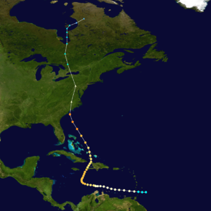
Because I know you all love historical analogs. Take a look at Matthew, and then take a look at the final path of Hurricane Hazel. That right turn is pretty spot-on. And the path into the Southeast US coast looks likely.

c79a9b92da2bd8eb62b49aaf7e31e21a.png
 
Jamaica is looking more and more like a pretty clean miss. That western tip of Haiti could get drilled. Thats major flash flooding terrain too... 5000 foot peaks grabbing onshore major hurricane moisture? A slow moving hurricane at that?
 
Latest NHC forecast moves Matthew much closer to the Florida coastline. Watches likely later tonight or tomorrow. My how things have suddenly changed!

Its going to be a nerve-racking forecast I think for the next few days as the path may just skim the coastlines of Florida northward with various impacts depending on where the core moves. More so, I think the intensity will be a wild card.
 
Last edited:
Back
Top