Hurricane Harvey: 2017 Central Texas Coast

I have been looking at that too Steve. One interesting thing will be to see how much the upwelling from the storm affects the SST and how much Harvey re-strengthens when he moves back out to sea. Another thing to consider is how slow the storm will grind over the Corpus area with its eyewall winds as it stalls and turns back around. If it doesn't make it as far inland as forecast you could see really powerful winds grind down on the area it hits, especially if the more bullish runs are to be believed and this storm makes it to Cat 4. The Yucatan couldn't kill it, Texas likely won't kill it, is there anything that can stop the dreaded "ZOMBIE STORM?!?!?!?!" (I just got an idea to pitch to Scifi Channel. Maybe even a Sharknado/Zombiecane cross over? Hmmmm.... October is almost here!)

Oh, I've been toying with a little idea since after Ike...actually have put some of it to paper... Homage to Mr. Romero.
 
Really concerned about the lack of attention along the coast / inland about this storm - mostly due to the forecast "Charlie-like" intensity burst and narrowing time frame to take action. I've been on the on the phone with hotels and some friends / chasers in the area and people are just starting to pay attention. I'm scheduled to arrive in Corpus tomorrow AM. Suspect the core will be east of Corpus in the darkness, but anything can happen. Epic flooding will occur, no doubt.
 
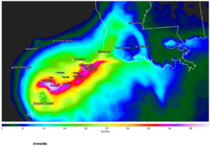
Our latest ECM rainfall forecast: Port Lavaca: 40 inches | Victoria: 30 inches | Houston 18 inches | Lake Charles 12 inches.accum_plot.png
 
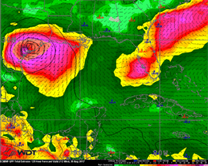
The 12z Euro is out to lunch, but sure is fun to watch! Shows a Texas landfall, it moves back out to sea after sitting on Corpus Cristi and got getting further inland, then hitting Lake Charles as a cat 3. While I agree with the idea of it moving back out over the coast and making it to Louisiana it is way off on its intensity forecasts IMHO.

GIF of the EURO here: https://twitter.com/SvrWxChaser/status/900820800630132737

EDIT: MANDATORY EVACUATION issue for Port Aransas, TX. Ferry to remain open until tomorrow morning, not sure about the causeways. Given how flat the island is, and the lack of adequate shelter on it I would not recommend any chaser attempt to ride out landfall on it or any of the islands unless you are Aquaman.
 
Not the best hurricane situation to chase - bailing on Corpus unless the next update shows a big push to the west - unlikely. Looks like Port Lavaca will be in right front quad, in the dark. ): Maybe a good way to end up stuck in flooding and closed roads for days+. Beginning to think the Glaveston area east might be a better chase location for round two. Fascinating forecast regardless!
 
I have arrived in Corpus Cristi and ready for the storm. 7am update puts Harvey 1mph away from Cat3 rating. Surprised at how much lightning is in the eye wall. Still have plenty of time before land but it has to move over the continental shelf so we shall see how much of a negative impact this will have on Harvey. I still see it being a cat3 at landfall.
 
I like the Galveston encore much better than Corpus to Pt O'Connor/Lavaca. Left jog would shake me out of CRP and hell no up toward O'Connor. Nowhere really to stay left side of landfall/eyewall. GLS offers spin-up tornado chances tomorrow without the night surge. Be safe!
 
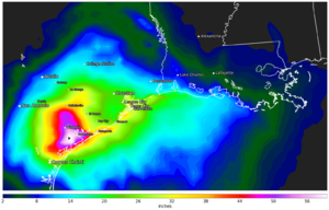
45 to 60-inch totals now being forecast on our latest ECM runs. I honestly cannot tell you the difference between these 12z runs outside of that they come to me from two different departments in the company and serve two separate purposes. Regardless, even 45 inches is a lotta rainfall!
20170825-12z-7-day-accum.png

2017082512_f129_gom_rtqpfex.gif
 
I like the Galveston encore much better than Corpus to Pt O'Connor/Lavaca. Left jog would shake me out of CRP and hell no up toward O'Connor. Nowhere really to stay left side of landfall/eyewall. GLS offers spin-up tornado chances tomorrow without the night surge. Be safe!

Agree. For anyone who has not chased the Glaveston area, Houston will likely be flooded as in past hurricanes, with much less rainfall. I-10 will be underwater, so your exits will be very limited for possibly days.
 
I'm not even sure I can fathom 60 inches of rain in such a short period. We got 20 here in CO that created the "1000 year flood" a couple years back. If we had 60" this whole place would have washed away down to Arizona.
 
GFS and ECMWF agreeing on a stalled storm for a week is very threatening. In the meantime, that was one of the faster eyewall replacement cycles I have seen... pressure continuing to fall as the eye begins its approach.
 
Back
Top