Great Lakes Drylines

Joined
Jul 2, 2004
Messages
1,781
Location
Hastings, Michigan
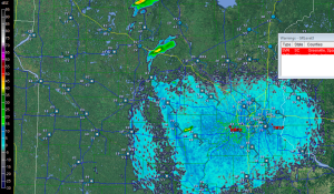
One doesn't associate drylines with the Great Lakes states, but while rare, they do occur here from time to time. Here's an example of one in central Minnesota that I came across earlier while sifting through my archive of radar images. Check out the station obs along the fine line and you'll see what I'm talking about. The contrast in moisture may not be as drastic as you'd find out in the panhandles of Texas and Oklahoma, but it's nevertheless respectable, and the abrupt veering of surface winds across the boundary is noteworthy.

Some may say that "dryline" isn't the right word for this. I don't know of a better term to describe the phenomenon, but regardless of what you call it, it's an impressive source of lift, and with supercells firing along it and three tornado reports logged for that date (May 10, 2011) by the SPC, it obviously did the job.
MN-Dryline-5102011-300x175.png
 
Going back to more historical cases, Palm Sunday 1965 had at least a "pseudo" dryline with it. Actually I believe a lot of the more intense Great Lakes outbreaks tend to have this type feature, given how vigorous the parent systems tend to be (I believe 4/3/56 is also one of those).
 
March 2nd 2012 featured a dryline as well.I know its not necessarily a great lakes setup but its a good recent example of a dryline making it this far east.
mcd0205.gif


There was a big Illinois day in either 2003 or 2004 that featured a dryline making it to almost Lake Michigan, the exact date escapes me but I know I've read up on it before. It does happen, and I know if we ever get a day going forward where that is forecast to occur, I have to make sure Im there!
 
For 2003 and 2004 in IL, the events that come to mind are 5/10/03, 5/30/04 and 4/20/04. 4/20/04 was not a "classic" setup by any means and was focused along a warm front so I don't think that would fit the bill. 5/10/03 was centered in the western portion of the state, but it also featured an unseasonably strong and rather fast moving upper trough at the tail end of the outbreak sequence, so that could be it.

These setups tend to feature very strong mid/upper level speed maxes and the 5/10/03 trough had a 100 kt 500 mb speed max at 00z 5/11 per the SPC archive. Upon second look though at the surface observations through that day, the dewpoints in behind the wind shift didn't drop as sharply as you would expect with a dryline, so that probably isn't it either. Same applies to 5/30/04.
 
Last edited:
Andy, right you are about the 1965 Palm Sunday Outbreak. Ted Fujita's synoptic analysis included what he called a "dry cold front," but while he referred to the air on the other side of the front as "cooler," when you look at the surface map, you see that it wasn't uniformly or dramatically so. What is striking is the abrupt drop in dewpoints, and again, the veering of surface winds. There have been other big tornado days associated with drylines in the Great Lakes region. West Michigan's only F5 tornado, the 1956 Standale tornado, looks to have been a typical warm front setup, but I seem to recall a met from Grand Rapids mentioning a dryline as part of the mix.

When a dryline shows up in my backyard, this far east of the Plains, there's a reason. The system is strong enough to wrap in air from the desert Southwest, and that suggests that conditions overall have conspired to produce a tornado-breeding system. What could be better than a string of mesos in the wide-open Illinois flatlands!
 
Back
Top