TL;DR: Since the 2008 post (herein) pointing to VISIT TRAINING MODULE 9.2.1, what progress has been made in identifying variables to use in analyzing for OFB that are likely to initiate future convection? (E.g. virtual potential temperature or its gradient.)
I’m posting my question here because it seems like a logical extension of the original discussion, and indeed resulted directly from it.
LONG VERSION: I moved to OK from NJ in Mid-2018, and until this year, it was not possible to travel more than an hour or so from Tulsa to chase. This year, most of my success has come from dryline chases, following fine line echoes near NEXRAD sites, and observing changes in the Cu-fields via satellite imagery. If an outflow boundary was pronounced enough to be detectable on publicly-available maps, that was OK, but there were several occasions where the text discussions mentioned outflow boundaries and I could not find anything in the surface data plots.
An internet search brought me to this thread, and I went through the VISIT module, and began working through the references at the end. I got off onto a tangent looking at modeling studies of cold pools and although most of them deal with tropical cold pools, it was still instructive. For instance, this paper did a quick review of atmospheric variables that could be used to detect cold pools:
Drager, A. J., and S. C. van den Heever (2017),
Characterizing convective cold pools, J. Adv. Model. Earth Syst., 9, 1091–1115
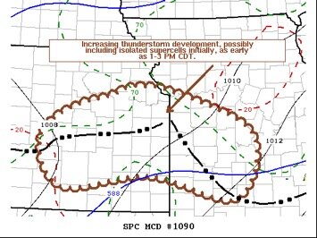
Virtual Potential Temperature did seem to have some value in identifying outflow boundaries, so I decided to try it out. On 6/25/2021 a Mesoscale Discussion was issued for East Central Kansas, based on the existence of outflow boundaries (which did not become apparent until I plotted the data myself.)

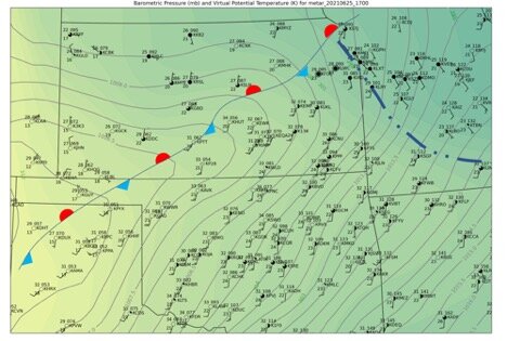
The surface analysis below presents virtual potential temperature as filled green contours. There is evidently a cold pool behind the outflow boundary in SW Missouri. (I analyzed the boundary in KS as a stationary front primarily due to the presence of a trough along which it was aligned.) Although this “pool” persisted after morning convection had cleared out, I just wasn’t convinced this was enough of a contrast feature to be useful.

Looking at a few other cases, including the study presented in
Borque, P., Nesbitt, S. W., Trapp, R. J., Lasher-Trapp, S., & Oue, M. (2020). Observational Study of the Thermodynamics and Morphological Characteristics of a Midlatitude Continental Cold Pool Event,
Monthly Weather Review,
148(2), 719-737,
it just didn’t look like virtual potential temperature (VPT) would be a good discriminator. The Borque, et. al. paper even purported to analyze a continental cold pool and the pools VPT found dissipated within an hour or two of initial formation. In the case of a post on the Hugo, MN tornado in another
thread, VPT analysis showed no cold pool at all.
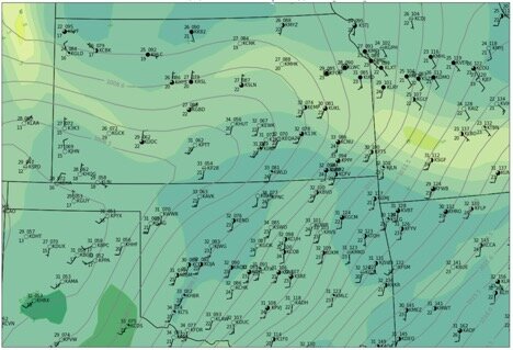
So I went back to working the VISIT references, and found a comment by the module developer (LaDue) in the notes to a paper by Hane, et.al: “I'll argue that Theta-V gradients is the correct solenoidal forcing mechanism for every boundary.” So I repeated the analysis using the gradient in VPT:

Now we see a pronounced feature in the VPT-gradient, aligned along the OFB in SW MO. This seems promising.
I know this has been a long post so far, but before I slog through too many more papers and test cases, I’m just curious if there is a better approach. LaDue’s comment certainly has given me more work to do. Any thoughts?


