Chasing in Dixie Alley

I find chasing in the South to be a different experience than in the Central Plains. If youve got the equipment, logistically it might not be different. But the facts of Southeast severe weather events do not change. There are several factors that separate the Southeast from other states in their severe weather set-ups. One of the biggest obstacles is terrain. Depending on the State your chasing in, whether it be Mississippi, Alabama, Tennessee, or Arkansas. You will have to deal with the rolling hills and trees that plague the region. Since storms do not have reguard to political or geographical boundarys, sometimes you need to take a windy backroad, or state highway. Thats leads to the second problem. Storm motions are very high. Almost all of the major south-east events occur during the transitional months. These storms often form in low CAPE, low instability environments and are often dominated by the extremely powerful deep-layer shear in the atmosphere. They move in speeds upward of 50mph and can be as strong as any Central plains storm. The third thing is the road network. Most of the roads really arent that bad, but in some parts of some states the visibility is unacceptable. If your left to taking state highways and backroads, they can weave and wind, be subject to being blocked due to flash flooding, downed trees or other hazards. Plus they limit the speed your able to drive. When your trapped on one of those winding roads, there is no other alternative. You cant drive faster then the road will let you, and you can become trapped in the path of the storm.
DSC02587.jpg


With that said, there are alot of great places to chase in the south. Some places are over grown but there are places where you can get some incredible views of storms. Some of the best spots ive seen for storms are around eastern, AR and the delta in Mississippi. Terrain out there is almost plains like, and you can see for miles. Assuming its not one of those rainy stratified set-ups.

DSC00340.jpg


A place i always hope a storm forms is locally. Here in Northeast, MS we have a special geographical feature called the black prairie. This place is rich in soil and nutrients and is very flat. You can ride 45 South from Tupelo past Verona and go all the way past Shannon and towards West Point. The terrain down that way is almost as close as your going to get to the plains, and even beats some places out there. This link includes some information about that black prairie for those who are interested. I learned about it in my Mississippi studies class.

http://mississippientomologicalmuse...itats/black.belt.prairie/BlackBeltPrairie.htm

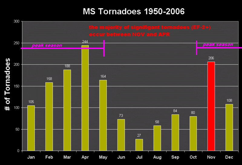
The last big thing about events in the south is the big thing about any other severe weather event. The timing is critical. Since over %60 of southeast tornadoes occur during transitional months, some events occur at night leading to the lack of documentation and chasability. I can tell you, ive waited on lines to come across the Mississippi river only to find them get warned when the sun goes down at 5PM. When you factor in all the different varibles into a chase out here, theres alot more then just the set-up itself. You try to hope a storm forms in a good visibility location, with limited or no cloud cover. Its rare, but events like 11/15/05 and 5/2/08 have provided limited cloud cover, but nothing like a dry-line type set up. Dixie alley tornadoes are particularly deadly, mainly because of the aforementioned reasons. Leading scientists and researchers claim that the reason for the large amount of fatalities in Southern states is because of the population density, the time of day, and because alot of people live in modular homes. When you factor in the terrains visibility, the cloud cover, the time of day, the speed the storms are travelling and the roads the storms are on. Its not hard to see the difference.
Heres some information on some Southern severe weather events.

http://alagenealogy.com/Historical ...ormation/Magazine Article of Tornado 1932.htm

http://www.usatoday.com/weather/tornado/wtordead.htm

http://www.srh.noaa.gov/srh/srnews/stories/2008/mississippi.htm

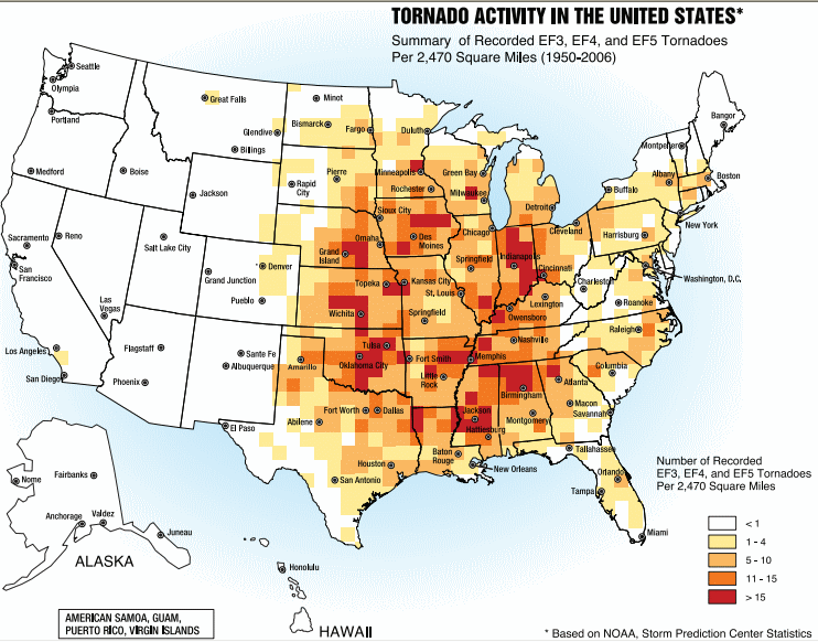
One can look at a graph of tornadoes on a national level, and see no distinction in the number of storms per state. Northeast, MS can hold its own with Central, OK
Tornado_Alley.gif


msTors1950_2006.gif


Events in the late season provide a higher chance of severe weather during the off hours. Wont lie and say im a weather expert because im self taught, but thats how i feel about the subject and thats all i got to say about that.
 
Last edited by a moderator:


One can look at a graph of tornadoes on a national level, and see no distinction in the number of storms per state. Northeast, MS can hold its own with Central, OK

Tornado_Alley.gif

Two problems with your chart showing that Northeast Mississippi hold it's own against Central Oklahoma. First, this map is F3-F5 tornadoes only; second, the largest bin (>25) is very vague. Oklahoma could be a 48 and Mississippi a 26 and they would both be bright red. Yes, the deep south gets it's share of tornadoes, but I highly doubt Northeast Mississippi can compare to Central Oklahoma.
 
Two problems with your chart showing that Northeast Mississippi hold it's own against Central Oklahoma. First, this map is F3-F5 tornadoes only; second, the largest bin (>25) is very vague. Oklahoma could be a 48 and Mississippi a 26 and they would both be bright red. Yes, the deep south gets it's share of tornadoes, but I highly doubt Northeast Mississippi can compare to Central Oklahoma.

Plus Oklahoma's terrain will beat out Mississippi's.
 

Interesting how it states Dixie Alley has more violent tornadoes, however, when you consider Dixie Alley has a higher population density, in theory there are more structures to base tornado strength. There could reasonably be just as many strong tornadoes in tornado alley as there are in Dixie alley that just don't hit anything. You can rate a tornado based on damage to trees (which are plentiful in Dixie Alley), but not on open prairies.
 
I chased in those zones this year and I was not satisfied at all.
To me, it depends on where you go: East Arkansas and maybe east MS is a chase territory but the rest is not so much chaseable. I think that if you see a good risk for tornadoes and if the next days there's nothing to do in the Plains, you can go.
 
This past spring, I was with Tempest Tours (wonderful bunch of folks) for eleven days for the second year before going out chasing on my own for several days. We were in very Southwest Missouri and drove across Arkansas to Little Rock trying desperately to catch up to a fast moving storm system headed east before finally giving up (5/2/08). We were back in Missouri again on 5/10/08 and just missed the Seneca tornado but filmed some of the damage. Both trips, I kept thinking to myself as we traveled through the forests and winding roads that we were just like the proverbial dog chasing a car. What the heck are we really going to do with it if we caught one?

Both of these sessions helped solidify my thinking about where to go. Just about anything east of US 75 through Kansas and Oklahoma and east of I-35 in Texas is off limits for me. I’m too much of a ‘flat lander’ and won’t waste my time or fuel in areas that have poor road networks along with very limited views of the horizon. I certainly won’t knock the folks that enjoy chasing in those areas because sometimes you just have to be happy with what is available locally, but I will take possible long views of storms any day over short, fleeting glimpses of “did I see something over there or not?â€￾ On the positive side, the blooming trees and hills were beautiful and quite photogenic that time of year and the folks were very warm and friendly.
 
My only experience even close to "Dixie" land chasing I guess would be SE Arkansas, which was pretty good (except it was night when I was there). I've never chased further east that far south.

From what I remember from my "normal" travels in that region, Mississippi and Alabama are pretty awful.
 

Very good link Mike, good comparisons there.

The killer tornadoes is definitely because of the timing, at least IMO. Since climatology trends indicate tornadoes hit later in the day/overnight in Dixie Alley, more people wouldn't be prepared for the storms.

As far as frequency of more violent storms...I wonder if population density has anything to do with it? I don't know how dense the population is in the south, I would bet it is at least comparable to the areas on the plains...but that is one working theory (more structures vs. the plains so more likely strong damage).

Either way, there is no doubt Dixie Alley is a very active place for tornadoes. Despite just about every condition being non-conducive towards chasing, I'd love to chase there sometime if the opportunity presents itself.
 
About the eastern 1/3rd of Arkansas, maybe a little less,. is very chasable terrian. I live in North East Arkansas, Newport to be exact, and I am very familiar with the entire Mississippi Delta region. I have chased from the Missouri bootheal all the way south into Louisiana. The land is very, very FLAT with nearly all in cultivation, Rice Soybean and cotton farms abound. There are areas with some bottomland trees that can get in the way of veiwing storms, although not enough to compleaty cause any problems with chasing in the area. As has been discussed is the fact that more storms than not occure after dark, but if you know ahead of time if it is going to be a daytime event don't give it up. You can chase some remarkable storms in this part of Dixie Alley.
 
tornado-011799.jpg


Northeast Arkansas was home sweet home for me from 1970 to 1999, before I moved to Virginia. It's coming up on the 10th anniversary of one of my best chases, January 17, 1999, when I caught this tornado from wall cloud to rope out along the Poinsett/Jackson county line southwest of Jonesboro (at Grubbs, not far from Newport, where Kelley lives) and a second one at 1/4 mile range about 15 miles east near Weiner about a half-hour later. Yes, one of my best chases was in January!

If A-plus terrain is western Kansas or the Texas Panhandle, Northeast Arkansas would rate a good solid B. Lot of open flat land, interspersed with wooded slough areas. Some of the Missouri Bootheel might even make an A-minus. Would concur with everyone here who warns about the big ditches and easily flooded roads, though.
 
Nice thread, Bob. My avatar is my only tornado catch in Dixie Alley (or anywhere), near Silver Creek, AL.

I have done a lot more chasing in Dixie than TX/OK, and have enjoyed both zones. Everyone has well documented the major differences between the two areas quite well.

But the challenge of seeing anything in the Deep South is part of what makes it interesting, and I have yet to see a chaser convergence anywhere. At best, I've seen one or two other chasers out (other than spotters and LEOs), and I've never had a hassle or been told to move away from an area yet.

While the Huntsville area has had some significant storms and some busy periods, my opinion is that the area around Tuscaloosa and over to the Mississippi border are getting more frequent tornados these days.

The one item I'd hope to focus on here is the small-cell storms, perhaps mini-supes, that can produce great structure and style without the big dynamics and area coverage of the Alley storms. I have seen and posted (and frequently missed video documentation) about many interesting rotational figures that were in very small storms.

I am hoping the price of gas will stay down this year, below $2 anyway. This will get me out on more storms than I was able to go after in 2008.

Last year I saw a Baron Services DOW parked at the UAH campus. I didn't know they had one, and don't know what their program is (and as a private firm, they have a wide-open field of options), but the idea that a DOW might operate in Dixie Alley is encouraging. Of course, they may take it west instead, or use it for landfalling tropical systems.
 
Take a look at this map: Mississippi Embayment. It clearly shows the area that others have mentioned, from the bootheel south and southwest along and either side of the Mississippi River to northeast Louisiana. Aside from storm mode (which most often isn't as ideal as out west), it's a great place to chase. Of course, there are always exceptions to storm mode :D.

You got to it before me. This is the map I was going to post:

StormGuyFromFlorida
Dixie_Alley_Chase_Terrain.jpg


In my experience:

NW to NC to C to WC AR pretty loaded with trees and hills/mountains. SW to SC AR deeply forested in pine and native hardwood, with some spotty open areas. Jackson, MS southward is very forested and hilly. AL has some chaseable terrain, but no large notable area. The southern 1/2 of GA has some chaseable terrain as well. FL panhandle to Jacksonville is lined with trees, but there are spotty open areas. Southward toward Orlando is pretty densly forested as well. There are some open areas further south of the hills near Orlando, but I have yet to chase the wide open everglades ;)

I concur with what most everyone else has contributed here. The challenges are multitude and different, but if you're one for a challenge, can afford the effort, and suffer from SDS, the area becomes quite attractive for certain setups.

5/25/2006 near Sikeston, MO - nice little cell complete with inflow tail:

2149895670100066693hfLQCZ
2149895670100066693S500x500Q85.jpg


2024090440100066693S500x500Q85.jpg


2874067770100066693S500x500Q85.jpg


2037320860100066693S500x500Q85.jpg


And here are some vidcaps of a post-sunset Tornado-warned cell in NW AL with ground-scraping wall cloud and meso structure:

http://s12.photobucket.com/albums/a234/StormGuyFromFlorida/Alabama/wallcloud3.jpg

http://s12.photobucket.com/albums/a234/StormGuyFromFlorida/Alabama/wallcloud.jpg

http://s12.photobucket.com/albums/a234/StormGuyFromFlorida/Alabama/tornado2.jpg

http://s12.photobucket.com/albums/a234/StormGuyFromFlorida/Alabama/mesolightning.jpg

http://s12.photobucket.com/albums/a234/StormGuyFromFlorida/Alabama/JPG_0008enh2.jpg

Winding roads and road conditions, lack of a consistent grid such as those found in farm country of KS, and towns with stop signs/signals located every few miles, etc. present some difficulties. Storm mode can make a "success" quite unsatisfying, but the challenge often makes success quite satisfying. There certainly are exceptions to the HP/bowing embedded/linear/50+mph storm setups. Just look up radar presentation of the Enterprise, AL tornado of 2007, SE AR and MS 5/2/2008, AR 1/21/1999, etc. The rarity turns those exceptions into gems, if you successfully chased them. BTW, where's Laubach on this thread? He had a nice catch near Memphis, TN last year.

Photography is very difficult in these areas. Aside from the aforementioned trees and hills, the typical south storm nature makes it a difficult subject. The storms move fast, the LCL's are typically very low, haze can be extremely high, power lines and other obstructions are everywhere, rain-free bases are often in short supply, and contrast is often quite low. On the other hand, if you document something significant, chances are, you are alone.

I would say in many of these areas, sticking to interstates as much as possible might be advisable if you are not from the area. I would try to position where there is visibility and make the most of the window of opportunity I have as a targeted storm approaches/passes, depending on pursuit possibilities. And not to sound like a broken record, but do plan your Mississippi crossing hours beforehand. The bridges are in short supply and separated by hours of driving. Good luck to those of you who take up the challenge!
 
Last edited by a moderator:
Back
Top