2024-05-19 EVENT: NE/KS/OK

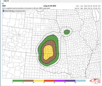
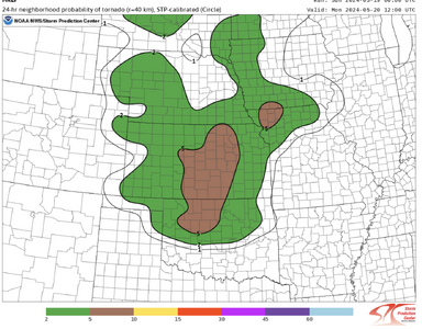
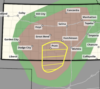
Unlike some prior setups this year (notably April 15th), I'm not seeing moisture depth being an issue across the board on forecast soundings; at least not where the moisture tongue hits the WF and curls back toward the triple point, which is the spot that has my interest for this day and wherever that sets up (north-central KS seems most likely, and has for a while IMO) is my target.

First sniff of the NAMNST is rather encouraging, as it seems the likely outcome is a happy medium somewhere between what it shows, and a cap bust.

Just the EHI plots on the GFS and NAM and their consistency with them remind me of May 26th, 2021. I had been focused on the target I described above, which was plotted over southwest Nebraska, but en route I caved and went down the dryline into west-central KS, and anyone who chased that day knows how that turned out. :rolleyes:

I did the exact same thing on that day, which has me also looking at the warm front as my target for Sunday, ha! I suppose the only exception might be if there is a good outflow boundary further south, particularly if the remaining parameters appear more favorable in that area.
 
Dryline bulge, surface low arc, warm front or southern dryline? The classic dilemma. The 00z CAMs continue the trend of wanting to keep the warm sector capped, with the gust front of forward-propagating MCSs the main things that initiate convection east of the dryline. Best case scenario may be the overnight MCS along the KS/NE border laying down a nice OFB along I-70 that intersects the dryline. I don't see a clear target yet out of those four. Thankfully it looks like a wake-up-in-Salina plan will keep all of the possibilities in play pending the look at morning satellite/surface obs. All things considered, it's an "if it's May, you chase" setup that I'm likely heading west on Saturday night for, Lord willing. If everything lines out as currently shown, I'll take the upward lightning-fest at the towers in Topeka after sunset!
 
Last edited:
Dryline bulge, surface low arc, warm front or southern dryline? The classic dilemma.
This really is a dilemma right now. On the best setups, it's a dilemma because all those targets have real potential. In this case, to me, it feels more like straining to find real potential with any of them. When moisture is late and shallow, my instinct usually is to hug the WF/TP where pooling can help mitigate the uncontrolled, deep mixing you're likely to see along the DL and over the open warm sector. The problem tomorrow is that deep moisture return is so late that I'm not sure even modest Gulf moisture will reach N KS/S NE by late afternoon. So, I'm currently torn between way up there vs. gambling on way S in OK where many CAMs initiate an isolated storm late. No room for hedging between those two options!

Overall, I expect a lot of high-based, outflow-dominant junk that quickly congeals into a nasty MCS across a large swath of KS, reminiscent of countless dryline setups W of I-35 in the moisture starved era of 2011-14. Man, those got old fast. With more seasonably impressive moisture, this setup would've been quintessential late season Plains (ala late May 2016) with modest bulk shear and a strong LLJ by evening yielding a high ceiling over a considerable area. I'm hoping for at least some solid structure early in the convective evolution, which might be most realistic with the riskier southern play. There is of course still some tornado potential -- it's May after all! -- but no one target looks impressive to me right now. Rozel happened in a droughty, high-LCL dryline environment surrounded by gusty junk to its N and S, so you never know. Or, perhaps if convection tonight overperforms, there will be a coherent boundary that focuses potential more than currently expected.
 
Yes, tomorrow has definitely become more complicated and downtrended rather a lot from when @Matthew Crowther opened the thread on Wednesday. That forecast sounding he posted has 83/68 with the moisture going most of the way up to 700mb - not an issue at all. Unfortunately it seems the GFS was being overly aggressive with the surface cyclogenesis and consequent mass response at the Day 5 range.
 
There has been talk of the OK play but surface temps look way too high down there, right now hoping for an early supercell neat the triple point somewhere north of I-70 before it turns into a huge mess.
 
There has been talk of the OK play but surface temps look way too high down there, right now hoping for an early supercell neat the triple point somewhere north of I-70 before it turns into a huge mess.
Man I’m getting a headache from picking out a target for tomorrow! I’m in Denver and planned to drive out to SW Kansas but I might change course and just head for Salina to keep the most targets in play at this rate
 
FWIW, here is the SPC evening guidance for tomorrow....

P.S. Note the dreaded right-handed mitten signature in Kansas!
 

Attachments

  • Screenshot 2024-05-18 at 11.15.39 PM.png
    Screenshot 2024-05-18 at 11.15.39 PM.png
    682.4 KB · Views: 19
  • Screenshot 2024-05-18 at 11.15.52 PM.png
    Screenshot 2024-05-18 at 11.15.52 PM.png
    815.6 KB · Views: 19
The nebulous nature of the midlevel flow is what is making this challenging. Models are showing the lead wave in the morning departing in the afternoon, which could leave the northern target in an area of subsidence. Mid to high level flow is shown to be much better along and south of the OK/KS border, and of course moisture is better there also - but I don't yet believe the cap is a surmountable obstacle there despite some CAM depictions of a storm. If one *can* go, I would want to be there over anywhere else.

I don't like the moisture situation in the northern target at the moment, and it looks too be that central Kansas is destined for the linear mode thanks to the consistent depiction of that MCS developing before noon west of the dryline. If a storm can get going ahead of the line there, it would make that target more attractive.

I'm in Salina and will have to hold off choosing a target until tomorrow when we have morning satellite and obs to look at.
 
The latest update hasn't released quite yet (we're like 10 minutes away), but SPC upgraded to moderate for wind and hail last night while also mentioning the potential for the D word.

I'll probably target the south end for the rogue supercell in NW Oklahoma that has been showing up on HRRR for quite a few runs now. Moisture is low 60's and nice helicity tracks. Don't think I'll lose too much by betting on this cell.
 
I don't have much confidence in much other than a big bowing segment and potential high-end straight-line wind even today over central Kansas. Perhaps an isolated cell can get going along the dryline out ahead of the cluster expected to initially develop over the Raton Mesa and have enough time to do something before being overtaken by the MCS. Outflow boundary should be pushing north in the late afternoon into southern KS. If a storm can get rooted in that boundary ahead of the MCS, it could produce a tornado. I'm planning to head to DDC, and if all I get is a monster shelf cloud today, so be it!
 
Still clear as mud. the short-lived lone supercell (before it gets swallowed by the MCS) is back for a couple of hours on the HRRR. Otherwise, it is join the hordes in OK. Then backside mammatus once the MCS takes over.
 
I have updated my tornado forecast by adding an enhanced tornado risk area. The CAM's and general guidance are pretty consistent that there will be two "tail-end charlie" opportunities in the area.

I haven't made up my mind about chasing today. If I do, I would head for Medicine Lodge (P28) or Alva as a starting point.
 

Attachments

  • Screenshot 2024-05-19 at 12.07.06 PM.png
    Screenshot 2024-05-19 at 12.07.06 PM.png
    507.8 KB · Views: 9
The outflow from the overnight storms has pushed into NW Oklahoma and is hard to locate exactly now. Visible satellite shows it was more like an undular bore with multiple peaks, probably somewhere just south of Woodward. The DDC radar loop showed two distinct OFBs earlier. It may end up lifting to around the Kansas border by storm time. I am going to head southwest to around Pratt to keep the southern supercell in play, but I'm not optimistic that it's going to exist. CAMS are showing that outflow from the MCS just blasting through everything, which given the Dcape amounts seems pretty likely. I'll settle for a derecho day followed by upward lightning at either a wind farm somewhere or in Wichita at the Maize tower farm. If the southern storm does go, it could be a Simla-like laminar structure show with the forced updraft in the low levels.
 
Back
Top