2024-04-26 EVENT: IA/NE/KS/MO/OK

I'll wager you a Diet Coke the next time I see you that, when the final surveys are in, the correct forecast would have been 'high."
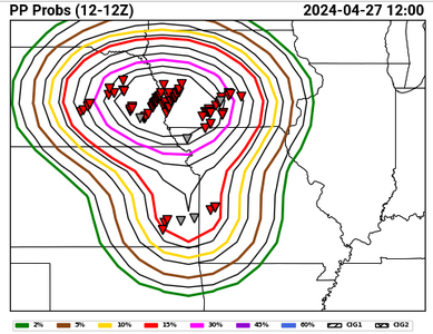
I'm not saying that "high" wouldn't verify. I think it only takes a single 80-km grid box exceeding 30% PP to get high, and I have little doubt that threshold was met. However, the particular product you showed indicates a substantially large area with PP > 60%, which I'm about 99% sure will not appear in an official verification.

ADDENDUM: Actually, I found the page where the outlooks are verified in real time. Here's what they have for yesterday:
Screenshot 2024-04-27 at 11-26-52 HWT SFE - Experimental Outlook Verification.png

Looks like almost an identical shape, but the core values are indeed suppressed quite a bit. Looks like 40% is about the max that got exceeded.
 
Makes me wonder if this is the same strong, low-level shear that made the tornadoes so visible?

In this Convective Chronicles forecast video that was prepared the morning of April 26, Trey specifically highlighted the probability of photogenic tornados, citing low-level shear but also noting that backing of the mid-level winds would provide good venting of the updraft. We often assume a veer/back profile is a negative factor, but Trey has referenced it as favorable jn this forecast, and I think I have heard him say the same in one of his other videos, either a hodograph tutorial or one of his case studies. See about 22:50 in on the video link below.

I’m confused, however, about his mention in this same video about the negative of meridional flow for Saturday April 27. Doesn’t the backed mid-level flow on April 26 also result in meridional flow?

 
Can someone clarify the following:

- Was there ay loss of life in Minden? I'm seeing reports to that effect, but nothing official yet.

- Was Harlan/Tennant a continuation of Minden or a new cycle? I stopped following the storm after Shelby.
 
Seen some chasers/researchers (notably Trey Greenwood [Convective Chronicles] and Cameron Nixon) posit that strong low-level shear, favorable for tornadoes, is not favorable for large hail production.

Just happened to be watching one of Cameron Nixon's hodograph videos this morning, and around 39 minutes in he discusses how low level shear impedes large hail production.

In the segment just before the hail segment, he discusses the myth of veer/back profiles being unfavorable. I haven't gone back to check observed soundings for this event to see if veer/back existed, but I do recall there being some meridional flow so I wouldn't doubt if there was a veer/back signature.


I guess this is why chasers don't get their windows busted by baseballs while watching tornadoes more often than they do.
 
Can someone clarify the following:

- Was there ay loss of life in Minden? I'm seeing reports to that effect, but nothing official yet.

- Was Harlan/Tennant a continuation of Minden or a new cycle? I stopped following the storm after Shelby.
There were 4 reported injuries in Minden, one later passed away from his injuries.

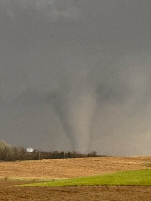
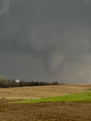
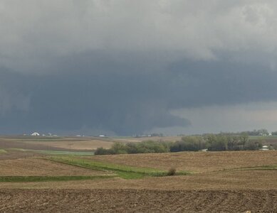
We chased the Minden storm and caught it a couple of minutes after it hit Minden. I see many reports of it being a wedge when it hit Minden, but it was actually quite a photogenic stove pipe in my photos at that time. It appeared to be lifting in the last cell pic I got before we went into town to see if were could help. I did get one more photo a few minutes later of it in the distance and it appeared to either have recycled or morphed into a large wedge so it was at least the same storm that produced the Harlan tornado. Prior to hitting Minden, probably 5-10 miles southwest there was a skinny rope that came into view and we saw some power lines down and minor damage. We were lucky to find a paved road and were able to head back north on it. That road ended up going to Minden where we caught the tornado.

Apologies for the noisy photos, they are cell photos taken through the window of a moving vehicle.
 

Attachments

  • IMG_1766.jpeg
    IMG_1766.jpeg
    107.2 KB · Views: 3
  • IMG_1770.jpeg
    IMG_1770.jpeg
    108.7 KB · Views: 4
  • IMG_1772.jpeg
    IMG_1772.jpeg
    108.4 KB · Views: 4
  • IMG_1780.jpeg
    IMG_1780.jpeg
    161.9 KB · Views: 12
Last edited:
Indeed @JamesCaruso VBV above about 400 mb is not a problem. Some say it even helps ventilate the storm. Now below 500 mb it creates a mess. Above it's OK. I think in one of my posts last week I mentioned how some VBV isn't an issue that high up.

One thing I can't stand - it's total vomit on the charts - is veered off 700 mb but 500 mb back southerly. It's especially puke inducing if 700 mb is a blast furnace. Get a couple clusters of storms negatively interacting. Then everywhere else turkey towers disintegrate. Ugh!

April 26 was a classic all is lined up 400 mb and below. Hodo was textbook below 400 mb. Moisture felt JIT but it was in time. Boundaries played their role as expected.
 
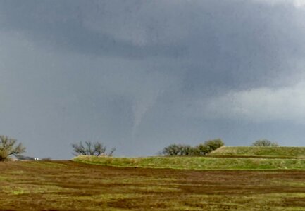
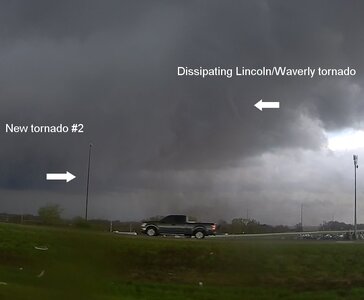
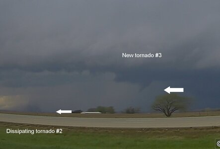
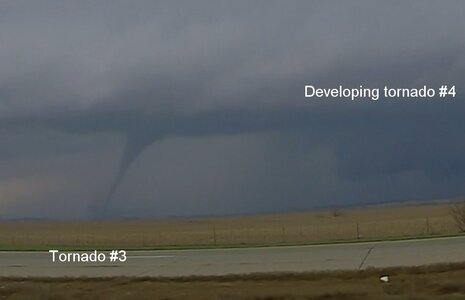
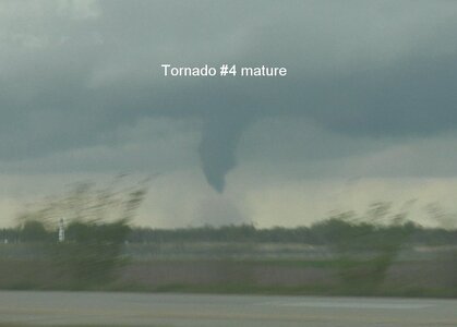
There are three additional tornadoes between Waverly and Greenwood that have not yet been officially counted/surveyed. They occurred in rapid succession, each new cycle overlapping the last with simultaneous tornadoes. Anyone who saw these, send your photos/location info to NWS Omaha to help them pinpoint the paths (apparently there was no damage from these).

These images are from my north/northwest-facing dashcam from I-80 eastbound between Waverly & 238th St. These all were west of Greenwood, before the Elkhorn tornado. The 4th tornado's maturation was in the small gap between my rear camera & driver's side camera view, but captured with my handheld camera.

Those first three are from my dashcams, the timelapse showing these is here:


april2624tor14a.jpg
april2624tor14b.jpg
april2624tor14c.jpg
april2624tor14d.jpg
 
We were talking about this at supper. Reading their forecast makes you feel like they would rather underforecast than be accused of blowing the forecast or hyping the weather.

Wichita forecasters have been interesting to read. One would hype Saturday, and then the next would list all the reasons why it might not happen in the next forecast.

There is well-known psychological bias at work here. Everyone was talking about how this past Saturday was going to be the "big day."
It was big, but Friday overshadowed it. So the linear mindset and thought process that humans have, the simple extrapolated logic is often "X day was much worse than forecast, so the next day (Y) has been forecast to be big, so that means that Y day should be even bigger!"

Of course, that's *not* how the wx, atmosphere, and climate work. It is far from linear and the details count. We are dealing with two logical fallacies, "correlation = causation" and "recency bias," and these two are among the most common fallacies out there!

The scale/enormity and shock/awe of a single big event puts many in a heightened state of awareness and worry, so any mention of
further high-impact wx potential, esp. soon after the big event, it sets people off b/c the shock and awe of the first event is still fresh in their mind (the recency bias). So people tend to overreact and worry a lot more in the short-term, and this leads to bigger media hype and bad/misinformation becomes more prevalent, and often get outs of control with bad/misinformation rife.

Now there is *some* truth here, as in "similar wx patterns often breed similar individual sensible wx events." So when a pattern exists that is favorable for high-end events of a particular type, you will sometimes see it become absolutely relentless and incredible.
I always say, "when it is favorable, it can be *really* favorable!" Examples?

April 2011
We all know the Superoutbreak at the end of the month, but there were several other significant/big outbreaks that
month that led to an incredible 758 tornadoes for the U.S. that month, by *far* the most tornadoes in any month on record.
The Superoutbreak total I think was about 225 tornadoes. So take that number out of the 758, you still have 533 tornadoes,
which in itself would be close, if not #1, for a record for U.S. tornado monthly count! So you see how "favorable" it was large-scale
for the month.

Winter 2022-23
The West was pummeled with repeated ARs all season, leading to all-time record rainfalls and snowfalls for a winter season at many locations.

2004 Hurricane Season
FL was hammered repeatedly by significant/major hurricane landfalls in a relatively short period of time.

2005 Hurricane Season
It was virtually non-stop across the entire Atlantic Basin, and many records broken. We saw things occur seasonal and with individual TCs we thought were not possible or never had seen before.


But as we have all seen, the mesoscale is tricky, and we still have severe limits as to our forecast skill, even when it is the day of such an event! From empirical observations, it appears there is a fine-line between minor and major tornado outbreaks. One thing off, say LFC is a bit too high, shear profile weaker at one layer, storm initial mode, overnight MCS wipes out the low-levels, the list is long, can make or break a major tornado event!

How many times have we seen it looks unreal or excellent digitally (or on paper) for various model forecasts, only to be scratching our heads as to the event underperforming? That proves our limits, and thus shows you can't simply extrapolate one day to the next when it comes to tornado outbreak potential. Of course, sometimes it works the other way, it does not look at impressive at all, and the event overperforms!

Don't get me wrong, we are getting better with mesoscale and tornado forecasting, but still have a long way to go.
This is what drives us to improve and do better, which is a great thing!
 
Last edited:
You can almost here the faint echos of people asking why there was no moderate or high risk today.

This never seems to sink in or get conveyed properly. The severe wx risk area from SPC are about coverage of all severe wx reports, they really say nothing about how intense or high-end any severe wx will be (hail, wind, tornado). You can have an area of MRGL risk, and a giant hail fall from just one or two supercells. This is what happened on the NC/SC border on 4/20/24. MRGL risk even at 20z, and up to 4.5" hail fell, and it was not isolated.

MRGL often gets interpreted as "borderline severe wx" I have anecdotally noticed. That not always the case!
Coverage is limited, but actual severe wx can be high-end.

One of most striking examples for tornadoes is the Chapman KS long-tracked, intense tornado on 5/25/2016.

For those that witnessed this storm, they said it was among the top, if not top, storm intercepts of all-time, yet
it was "only" in SLGT!


Conversely, people see a MDT or HIGH RISK, and often think or will post, "MONSTA TOR OUTBREAK 4-CAST!!!"
That's not always the case, the risk levels are often heavily weighed b/c of straight-line winds and/or large hail
potential! Even when tornado risk is high, that does not guarantee "epic tornado outbreak."

Unfortunately, context and perspective are lost or ignored much too often these days. :( Ever notice that
all significant severe wx risk days all too often by some portrayed as "gonna be the worst ev-AH!" and it is not
always the individual or armchair forecaster on social media. Not good. This does much more harm than good
IMHO b/c of constant crying wolf mode and public apathy that develops and becomes ingrained towards wx in
general in society.
 
Last edited:
Seen some chasers/researchers (notably Trey Greenwood [Convective Chronicles] and Cameron Nixon) posit that strong low-level shear, favorable for tornadoes, is not favorable for large hail production.
Yes, I have seen this many times. Some days, all or almost all reports are large hail, some days, a huge amount of blue dot, straight line wind damage, and little or no hail/tor reports. For 4/26, I noticed as well, lots of red dot tornado reports (even when you take out all the duplicate reports), and an unusually small amount of hail/wind reports, relatively speaking. How often do you see the preliminary tor count on a big outbreak day exceed the number of hail/wind reports combined? Usually, these days are when a TC makes landfall or the days following when the TC is inland. Hail reports are almost non-existent, with some wind reports, but the tornado count is high.

Here is one of the most striking examples. Remains of Hurricane Ivan over the Mid-Atlantic 9/17/2004.

Tons of tor reports, no hail reports, and minimal wind reports! Now look at a separate severe wx event in the central U.S. -- almost all large hail reports. Obviously a distinctly different atmosphere!
 
Back
Top