2024-04-26 EVENT: IA/NE/KS/MO/OK

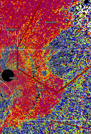
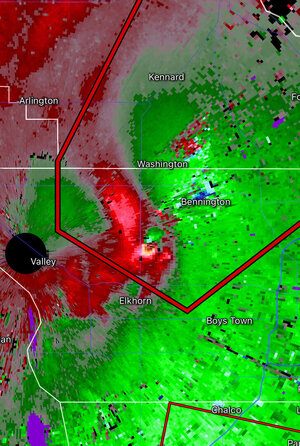
NE mesonet showing the warm front has made it well into southeastern Nebraska. Currently there's a PDS tornado warning for the isolated supercell north of Lincoln, although recent radar scans seem to indicate weakening.
 
Indeed. Cyclic supercell now in Douglas County NE looks to be producing again near Bennington with debris apparent on correlation coefficient view, co-located with velocity couplet.
 

Attachments

  • corr coeff 04262024.jpg
    corr coeff 04262024.jpg
    646.4 KB · Views: 10
  • velocity 04262024.jpg
    velocity 04262024.jpg
    321.6 KB · Views: 6
I was kinda looking at today as filler between what I thought were gonna be the 2 bigger days... boy was I wrong. 70+ reports and a tornado emergency so far is incredible. My thoughts are with those who were in the path of the multi vortex that went through Minden and everyone else who's been affected.... hoping for the best. The northern action looks to be crossing into stable air, but a few cells to the south still have some steam. People are gonna be on edge if tomorrow shapes up to expectations.
 
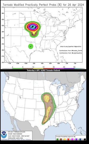
You can almost here the faint echos of people asking why there was no moderate or high risk today.

We were talking about this at supper. Reading their forecast makes you feel like they would rather underforecast than be accused of blowing the forecast or hyping the weather.

Wichita forecasters have been interesting to read. One would hype Saturday, and then the next would list all the reasons why it might not happen in the next forecast.
 
I've seen this discussed before, but here's another example of a day that is unarguably a tornado outbreak with a relative dearth of hail reports (especially significant hail).

I do not know the reason for this - whether it is a reporting issue/bias or true atmospheric character.

canvas.png
 
I've seen this discussed before, but here's another example of a day that is unarguably a tornado outbreak with a relative dearth of hail reports (especially significant hail).

I do not know the reason for this - whether it is a reporting issue/bias or true atmospheric character.

View attachment 25022

Seen some chasers/researchers (notably Trey Greenwood [Convective Chronicles] and Cameron Nixon) posit that strong low-level shear, favorable for tornadoes, is not favorable for large hail production.
 
Even without the additional tornadoes that will be found by surveys, the correct forecast yesterday was "high risk" on the SPC scale.
 

Attachments

  • Screenshot 2024-04-27 at 8.42.54 AM.png
    Screenshot 2024-04-27 at 8.42.54 AM.png
    372.7 KB · Views: 17
Even without the additional tornadoes that will be found by surveys, the correct forecast yesterday was "high risk" on the SPC scale.
Keep in mind that the spatial smoothing radius used on that site does not match the one used by SPC for its official forecast verification. The above overly smooths things and thus produces higher practically perfect probabilities than SPC's verification system does.
 
The above overly smooths things and thus produces higher practically perfect probabilities than SPC's verification system does.

I'll wager you a Diet Coke the next time I see you that, when the final surveys are in, the correct forecast would have been 'high."
 
Back
Top