2024-04-30 EVENT: NE/IA/KS/MO

Joined
Aug 19, 2005
Messages
272
Location
Atlanta, GA
I am a tad surprised today is not being discussed, I guess everyone is fat dumb, and happy already? I tend to like less hyped 2% or 5% days anyway. We have two more days on this excursion and hope to make the most of it. The obvious play seems to be SW IA into far NW MO, but how far south? One consideration is not getting too far away from tomorrow's target farther west in KS. Forecast soundings and UH tracks there look promising, but an eye should be kept on NE Kansas. In Topeka, waiting for further data.
 
After four days of chasing, one day off, a travel day to get in position and little time to post, I'm out for today's chase in Iowa. Just in time mid 60 dews, reasonable T/Td spreads, nice helicity tracks, semi-looping hodo's and hopefully a reduction in the hordes that were out on Saturday are all looking favorable at the moment. Surface winds appear to be a bit southwesterly so that could look better. Right now I like just north of I-80 in late afternoon and hopefully catch a tor before it lines out later.
 
Last edited:
I am a tad surprised today is not being discussed, I guess everyone is fat dumb, and happy already? I tend to like less hyped 2% or 5% days anyway. We have two more days on this excursion and hope to make the most of it. The obvious play seems to be SW IA into far NW MO, but how far south? One consideration is not getting too far away from tomorrow's target farther west in KS. Forecast soundings and UH tracks there look promising, but an eye should be kept on NE Kansas. In Topeka, waiting for further data.
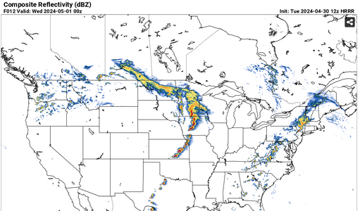
I'm back in Michigan for this cycle, but would concur with SW Iowa today, perhaps a zone initially along I-80 and the HW 71 corridor [Atlantic] to see what materializes this afternoon along the inbound front, forecasted moisture tongue/ pooling and pronounced diffluent split at 500on both 06z NAM3k and 12z HRRR. That way, dependent on what actually does transpire today, one could stay in Des Moines or Omaha this evening and plan a route towards I-70 and the Topeka/Salina region for Wednesday 5/1.
 
Northeast Kansas is my virtual target today. Regrettably I'm not out there yet.

Surface low and WF do make it up into eastern Nebraska and western Iowa. History likes to repeat. However instability will ramp up quickest farther south. Plus the prefrontal trough punch is a little stronger into northeast Kansas. Normally I love my boundary intersections. Today I like well south of the WF.

Very subtle boundary could exist in southeast Kansas this morning; which if true, would lift into northeast Kansas. We're really just working with differential heating. No true morning showers other than departing KCMO now.

Nothing squirrelly is seen in the hodographs. In fact the turning to straight west at 500 mb could promote some over achievement today. Probably for the best (public perspective) that the forcing is a little subtle in the target area.
 
I had one heck of a busy work weekend and into today, so only catching up on things now! I think I would be targeting eastern Kansas, as I worry about the amount of moisture to play with further north as the cold front pushes through quite fast. Kansas is on the edge of the best flow until after 0Z, so I don't know how much that will affect things.
 
Another good Plains event today. A couple of the tornadoes in Kansas were very photogenic. Also, the supercell down along the Red River in southern Oklahoma has produced some remarkable oddities visible on the nearby KFDR radar tonight.


I don't have unlimited PTO, so I chose to sit this week out so I'd have enough left for an active May. Between work and trying to finish up video from this last trip, I didn't get any real look at today's setup. But I think I probably would have been likely to choose the Omaha target at least initially, hopefully seeing some of the factors Jeff noted in time to get down to Kansas. I can't say if I would have made that decision or realization in time (if at all) though.
 
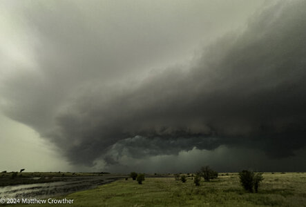
I was on a couple different storms to the north of the one Dan mentioned. I'll be making a REPORTS post about it tomorrow at some point. No tornadoes, but got some decent structure shots, saw a few funnels, and got several good looks at multiple rotating wall clouds as the storm cycled. It was definitely an eventful, if not unexpected, day down here in SW OK.
 
I had planned to go to Topeka and adjust from there for the "right exit region" play but was talked into going to NE. I was on the cell by Nebraska City as it started and it really looked like it was going to drop one south of Hastings Iowa. It had rapid rotation and I was in position for another cross road intercept but it just could not do it. It kept having cells to its south pop up and interfering with it killing most chances. I stayed on it until south of Des Moines as it attempted a few times and might have dropped one by Macksburg where a nice funnel was observed. Overall bust and I should have stayed with my gut and headed to Topeka. Today I will be out again.

I watched the cells in Oklahoma when I arrived at the hotel and just WOW!
 
Back
Top