2020-03-28 EVENT: IA/IL/MO/WI/IN/TN/AL

Outflow boundary is obvious in central Illinois, well south of the WF which is up on I-80. Debate centers on which will be sloppy, and which chasable. I favor the OFB farther south, despite encroaching rain. North could be even sloppier late. Encroaching rain should anchor OFB. So I'd wait for that later. Believe some CAMs with renegade warm sector storms are actually keying in on this OFB, not free warm sector.
 
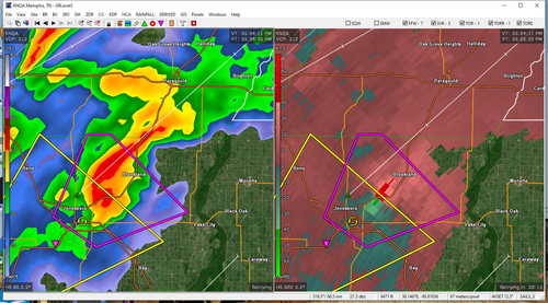
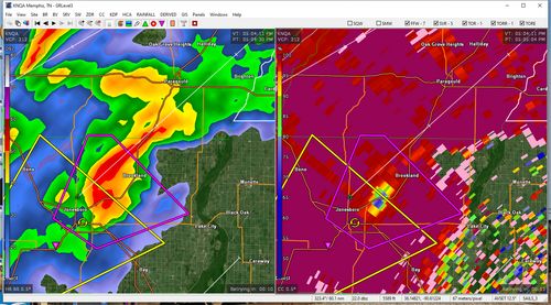
Arkansas (not even in the title list for this event thread) with a large and damaging tornado from Jonesboro-Brookland. May still be on the ground.
 

Attachments

  • NQA_2204.png
    NQA_2204.png
    909.2 KB · Views: 0
  • NQA_2204_CC.png
    NQA_2204_CC.png
    879.6 KB · Views: 0
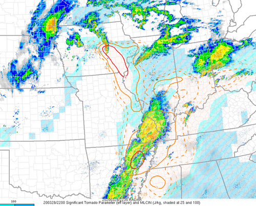
Jonesboro tornado high-end EF4 looking, the damage pictures I've seen so far looks solidly EF3+. Interesting that the realtime STP on mesoanalysis correlates with the only areas to see tornadoes so far today. Short-term model guidance indicates a more favorable tornado environment evolving ahead of the tornadic cell in the MO bootheel after sunset in the Evansville/Hendersonville area.

march2820stp.png
 
Can someone explain to me why SPC went PDS with their Midwest watch? Given the ongoing convection, extensive cloud cover, and possible subsidence moving in from the southwest, I think it was pretty obvious instability parameters were not going to be realized. I certainly wouldn’t question a tornado watch there, just as an assurance, but a PDS one? I don’t get it.
 
Yes, the threat was very apparently diminished as soon as the first visible satellite image of the day could be viewed. Any benefit of the doubt you could reasonably hold out for it was all but gone by midday. I don't know if this is true, but there seems to be a "forecast momentum" protocol in place - an ominous outlook rarely is downgraded, even if the degree of risk has clearly undergone a significant reduction. I'm not sure why that is, possibly there is a recently-evolved social science principle that it's better for a forecast like this to bust than to be downgraded mid-event. I can remember big outlooks being downgraded in the early-mid 2000s, but it seems very few have been since then. Maybe a topic for another thread.
 
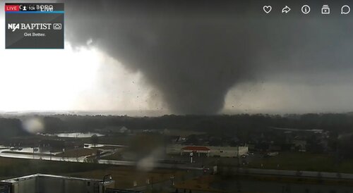
It looked like the cell that spawned the Jonesboro tornado, had cycled a tornado at least once more before that one. But the ArkDoT video of the particular Jonesboro one, was impressive. From a stationary highway cam, it showed a thin rope grow into a swiftly moving, decent sized cone looking tornado and it appeared to still be growing and throwing debris as it moved off screen, throwing debris and power flashes in the outer area of Jonesboro. The rate at which it was growing, looked impressive. It was in a small frame of reference and was gone very quickly with it being close to the cam and speeding along, yet grew intense in seconds.

Very unfortunate that it all happened in an area with lots of buildings and possibly people. Everyone was probably watching the Iowa area near the warm front and low and waiting on the Illinois area to see what might happen, when the dagger was out ahead of the cold front in a somewhat messy line. Most people knew there was a threat along that long line, but the show was fixated on the moderate risk vicinity for hours/days. Luckily only a few minor injuries have been reported in that area. It looked like it may have been more of a commercial, restaurant, service industry/highway exit hotspot area. Or at least next to it. COVID-19 may have saved some people today.
 
The environment down there didn't seem to portend such a strong tornado. I looked at the surface obs during the tornado, and the nearest ASOS just to the south had southerly winds at only 10 knots - much weaker than farther north. I'm wondering if there was an outflow boundary in this area or possibly an MCV? I have no idea as I was never even remotely considering that area, and never looked at it in detail.

Was the Dewhirst tornado photo from Jonesboro, AR?

David, yes, I believe this was from a tower cam.
 
Yes it was. They local news was live streaming it as it came into the city. Yea images of it emerged on Twitter very quickly
 
Back
Top