2023-05-11: EVENT: KS/OK/TX

Once we approached 0-01z the LLJ increased a bit which I think aided in getting these guys rooted into the boundary layer.
I just checked the 5/11 OUN 21Z sounding and I so see that the Buoyancy value was very marginal. I guess this is a Meteo 101 question, but: what is the cue that parcels are not surface/PBL--based?

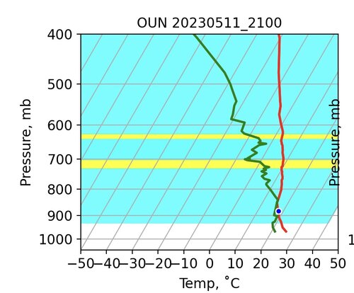
The 21Z profile does not look like one I'd associate with elevated convection. I've always assumed the phrase "rooted in the boundary layer" to mean that surface-based (or parcels originating in the boundary layer) can reach the LFC, whereas elevated convection occurs when PBL-based parcels cannot reach the LC but an elevated parcel can. Here's what I mean. In the image below, the yellow bands represent layers which satisfy the Carlson-Lanicci criteria for EML transition layers, and the cyan bands are layers where the static stability is ≤ 4.5˚C/100mb.
What prevents surface based parcels from reaching the LFC (which is about 900mb, give or take)?
Untitled 2.jpg

BTW--I do appreciate the help understanding what's going on so I can make the most of my opportunities to get out and observe storms. Thank you.
 
The theories on failure mode, if correct, beg the question of why SPC issued this MSD, which was for the hyper-local area where the initial storms formed:


Very difficult when chasing to avoid anchoring on things like this. As a non-meteorologist, it’s hard to ignore what the experts are saying, especially in a nowcasting situation like that when you are out in the field, trying to make decisions, and don’t have time to dig into the data yourself.
 
Last edited:
I just checked the 5/11 OUN 21Z sounding and I so see that the Buoyancy value was very marginal. I guess this is a Meteo 101 question, but: what is the cue that parcels are not surface/PBL--based?

The 21Z profile does not look like one I'd associate with elevated convection. I've always assumed the phrase "rooted in the boundary layer" to mean that surface-based (or parcels originating in the boundary layer) can reach the LFC, whereas elevated convection occurs when PBL-based parcels cannot reach the LC but an elevated parcel can. Here's what I mean. In the image below, the yellow bands represent layers which satisfy the Carlson-Lanicci criteria for EML transition layers, and the cyan bands are layers where the static stability is ≤ 4.5˚C/100mb.
What prevents surface based parcels from reaching the LFC (which is about 900mb, give or take)?

View attachment 23809

BTW--I do appreciate the help understanding what's going on so I can make the most of my opportunities to get out and observe storms. Thank you.
Great question... By all means the sounding says all the storms should have been surface based.

But think of this. The storm that prompted the tornado warning in Byars after the Noble tornado. That storm had been around for a few hours. I wish I had the 1-min goes data available to show you. But i don't. So here is what I noticed... that storm formed almost right after the Comanche storm dissipated. It then struggle and looked terrible for a few hours, but somehow still managed to hang on. Then once it got to Byars around 900-930 pm it went boom.

You could clearly see this storm began to ingest some nice thick juicy air as the IR satellite presentation was the most impressive of any of the storms to that point in the evening. Very very cold tops indicative of a very strong updraft.

But this storm was in a similar environment as all the others. It should have been surface based that entire time too. But it struggled? Why?

Not sure exactly, but there was something limiting it. Personally, i think the inflow layer wasn't getting into the high theta-e air which resulted in very mediocre updrafts. Once it tapped into that air it went crazy.

Byars storm pops around 01:50 UTC

 
Its even easier to see on the 13.3 um band


Hurry and look it up before the archive isn't available anymore

What you said makes sense. Certainly there were plenty of attempts by those early storms to produce a tornado. This clip (Bradley Supercell link) is from a cell near Bradley. I personally think it is absolutely gorgeous, and stopping to get this video is probably a big reason why I never got north in time to pick up the intensifying storms.

The wall cloud near the end of the clip did produce a brief funnel cloud and then nothing more.

Bradley Supercell

I think your explanation is worth looking into as it does explain a lot of what I saw.
 
@Brian McKibben ,

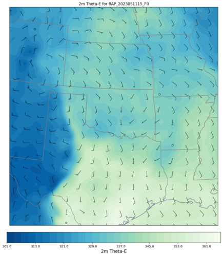
I looked at the distribution of ThetaE and there was definitely a pool of lower-ThetaE in the target area until about 21Z, probably due to the overnight convection still ongoing in the morning. (The chart below is the 15Z RAP 0H Analysis file.) By 21Z, this [cooler] air had largely been replaced from the south (not shown.)

The ∆ in Theta-E by 00Z was ~10K --- just not sure how to assess whether or not that is a big difference. (Note the RAP shows a wind-shift line near the southern-most extent of the lower-ThE air along the Red River. It was quite evident in the 15Z METAR data.)

Thanks again. I appreciate the willingness of folks here to help the rest of us learn to better "our craft".

RAP_20230511_15Z_F0_2m Theta-E.png
 
Last edited:
I just checked the 5/11 OUN 21Z sounding and I so see that the Buoyancy value was very marginal. I guess this is a Meteo 101 question, but: what is the cue that parcels are not surface/PBL--based?

The 21Z profile does not look like one I'd associate with elevated convection. I've always assumed the phrase "rooted in the boundary layer" to mean that surface-based (or parcels originating in the boundary layer) can reach the LFC, whereas elevated convection occurs when PBL-based parcels cannot reach the LC but an elevated parcel can. Here's what I mean. In the image below, the yellow bands represent layers which satisfy the Carlson-Lanicci criteria for EML transition layers, and the cyan bands are layers where the static stability is ≤ 4.5˚C/100mb.
What prevents surface based parcels from reaching the LFC (which is about 900mb, give or take)?

View attachment 23809

BTW--I do appreciate the help understanding what's going on so I can make the most of my opportunities to get out and observe storms. Thank you.

Keep in mind that each parcel has its own LCL and LFC. There is no "environmental" LFC that is fixed at one value.

A great indicator that storms are not surface based is higher bases than implied by the LCL of surface based parcels. Another good indicator is that updrafts don't appear as robust as might be implied by SBCAPE, although that is more difficult to ascertain from visual inspection of storms.

Having forecasted this event and chased from Norman, OK, my suspicions are (1) the atmosphere was more "worked over"/"overturned" from morning precip than the models suggested, (2) there may have been residual weak subsidence immediately behind the trough axis, which would have been maximized in SW OK over other areas further N/NE, (3) the trough itself was starting to fill in, so dynamics impacts were less pronounced, and (4) (and possibly most important), low-level shear just wasn't that great, even after the nocturnal LLJ kicked in.
 
Back
Top