• A friendly and periodic reminder of the rules we use for fostering high SNR and quality conversation and interaction at Stormtrack: Forum rules

    P.S. - Nothing specific happened to prompt this message! No one is in trouble, there are no flame wars in effect, nor any inappropriate conversation ongoing. This is being posted sitewide as a casual refresher.

2019-05-28 EVENT: IA/IL/KS/MO/OK/TX

Joined
May 6, 2005
Messages
276
Location
Moore, OK
Looks like our southwesterly flow is on its way out today and tomorrow. The longwave trough is now positively tilted. Could see 50-70kt at 500 hPa throughout the warm sector. The warm front looks to set up near the I-80 corridor. 12z NAM is forecast MLCAPE near 4000 along DL into KS/OK and along the WF.

I haven't looked at the WF much. My focus is along the DL into OK. Several CAM solutions continue to show convection developing around 22z. 0-1km SRH doesn't look overly impressive, but greater than 150 m2/s2 could make things interesting. 12z sounding form OUN and FWD showed a pretty stout CAP. This should suppress storm converage if storm can form. Large hail seems likely with bulk shear >40 kts and large CAPE. If I was chasing i would set up west of OKC with good N/S road options to get into place.

Be safe everyone.
 
Somewhat half-hearted chase today as I don’t like the terrain in eastern KS into MO, don’t want to screw around with river crossings from SE NEB into IA especially with the flooding/road issues there, etc. OK out of range (started the day in McCook) and not a fan of eastern OK either. Don’t like the early convection that went up in KS in the I-35 corridor and is now moving into northeast KS / SE NEB but rolling the dice on recovery and destabilization back to the west in the SLN area, where it looks like there is some clearing. Think as a result of the early storms the cooler air / synoptic boundary is sagging further into KS as opposed to remaining along the KS/NEB border as progged. Hoping to play the outflow-reinforced boundary somewhere around SLN, heading there now but prepared to adjust from there as necessary. This may be a wishcast more than anything but taking a chance on whatever opportunity may exist in more favorable terrain.
 
Wind profiles are more favorable initially for a tornadic threat across the northern target, particularly in NE KS, though quick congealment into a messier storm mode looks likely as storms progress into SW IA and N MO, eventually reaching W IL after sunset. I'm sort of ambivalent at how much of a strong tornadic potential exists today, and ongoing convective activity north of the warm front is making mesoscale forecasting more critical today. Some high end damaging wind reports appear likely too, especially across IA, MO and into IL, as well as the usual mesovortext tornadic activity (RAP SRH profiles are quite high across S IA and far N MO later this evening) and mid-level lapse rates are quite stout even into WC IL. Further south, storm mode is more more discrete, though wind profiles don't appear as favorable for tornadic activity, at least prior to 0z, except for cells that form closer to the Red River in S OK and N TX. I wouldn't be surprised to see some tornado reports down there, however, as the 850 mb jet ramps up between 01z-03z.
 
Convection has departed the warm sector. Surface low in Kansas should stall the sinking outflow boundary OFB and perhaps promote a slow lift north. OFB is currently over the populated KCMO Metro area, not a good place.

Winds surface to 850 mb will start increasing in Kansas ahead of the DL/CF. SRH will increase along that OFB toward 00Z. Despite late start, several hours of heating remain. Low clouds should gradually break up at least in spots.

While the OFB is the highest odds, looks like SRH will be enough into south-central Kansas. Oklahoma might even have enough deep layer shear. HRRR can't make up its mind on OK storm mode, but sups possible that far south.
 
Another target is near the surface low/occluded front in northwestern/north-central Kansas and adjacent portions of southern Nebraska. Deep layer shear will be strong, but I’m not a fan of a weak low-level jet and veer-back signatures in the 1-3km layer. You’ll probably get a fair amount of transient/hybrid supercells, but the wind profile is far from ideal, especially for tornadoes.

Watch the boundary/warm front north of Kansas City. Storms in far northeastern Kansas may be moving north too quickly to latch onto the front, but other storms could do so later. This area seems to have the greatest tornado potential, even though storm mode is not entirely clear.

Low-level hodographs look relatively small until last minute (near and after 00z) from south-central Kansas, SSWward toward the Red River. You’ll probably get a few supercells, but the tornado threat appears more conditional.

If I was starting from home, I’d probably chase the southern target in Oklahoma, but that’s not an option since I chased Illinois yesterday.
 
Over in Reports @JamesCaruso asks about which storm (north/south) produced the Tipton show. I'm not sure since I was virtually watching a large wedge approach my hometown KC from my college town Lawrence. That debris on dual pole still amazes me!

Tipton et al show reminds me a lot of Chapman. Many of us blew off the triple point for juicer air and more backed winds in 2016. Lovely turkey tower east of ICT. At least 2019 produced east, just rain wrapped. However Tipton gave the best show. Chapman also started a little weak on radar, and close to drier air. Really the two cases seem very comparable to me.

I'm an outflow guy; but, perhaps I need to give a little more respect to the triple point. No idea what I would have done in the field.
 
Thanks @Jeff House . Actually, I missed Chapman too, but I won’t get into that right now 😒. Was actually wishcasting for a “Bennington III” on Tuesday. I think the problem was I was sort of “in between” targets - not wanting to commit to the urban area target out east, but yet was too far east relative to the triple point. I suppose Salina was a “valid” target, and a couple other chasers that got Tipton reported starting from there, so I guess I just waited too long to go after the Hays/Russell CI. As I mentioned in Reports, I thought I was in a good position relative to the surface low, just south of the front, and that Hays/Russell was actually under or even west of the low. The rule is generally, “If a storm goes up in your target area, you go after it.” Well I just didn’t really view the Hays/Russell CI as being in “my” target area, which is part of the reason I disregarded it. I also wasn’t really thinking of it as a “triple point” because it wasn’t a true dryline, winds were veering out in the warm sector, etc. I just plain was mentally out-to-lunch on my analysis that day, for a variety of reasons, none of them good. Some days have analysis errors, some days have execution errors, this day had both. I have to go back and re-analyze and learn from it, but I just can’t stomach doing it now, it’s just going to make me feel even more regret.

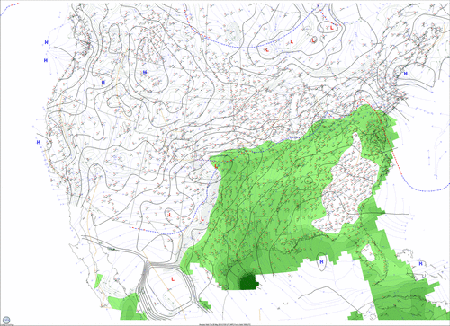
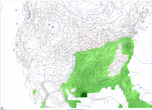
I don’t really rely on these surface maps with their computer drawn fronts when forecasting, except as an occasional reality check, but am posting these just to give some visual on it, I do think it shows it was a somewhat funky situation, with the earlier image showing an occluded front in a position I can’t remember ever seeing in the past, and the later image showing the triple point behind the low, which kind of gets back to what I was saying about the CI almost seeming under or west of the low. Maybe these maps are meaningless, I don’t know. One thing that I am pretty sure is depicted accurately is that the front was more SW/NE there, and more E/W near Salina, which is another reason I preferred staying to the east.

Insights (or criticisms) welcome.

1313BD29-21EF-469B-B955-95964B994219.gifD86AE429-214E-40D6-BC56-869E4A40B90E.gif
 
I wouldn't necessarily follow automatically drawn fronts on computer analyzed plots - algorithms to plot these are still primitive and they can result in errors. Furthermore, sometimes some boundaries just aren't that important for detailed analysis. It seems like in this case the occluded front in W KS did more to confuse than to enlighten you, Jim. I would suggest just sticking to keeping an eye on basic observations.

I agree with the crowd comparing this event to 25 May 2016 (the Chapman tornado event). If you watched visible satellite in KS on Tuesday you could quite clearly see the pair of tornadic storms in NC KS going up on what appeared to be the dead-center of near-surface rotation, as low-level cumulus delineated it pretty clearly. It was a thing of beauty, really. As to why it went so crazy...probably a nearby boundary, but surface obs (even from the Kansas State mesonet) weren't really sufficient to make it clear. However, in hindsight, it was probably a pretty good idea to stay close to that boundary region.
 
To Jeff and James, the Tipton tornado and others were from the southern storm - the first one that popped up at initiation time. The surface pattern seemed fairly unique to me insomuch that I hadn't chased a setup quite like it before. You are correct that the true triple point seemed to be on the northwest side of the low. This was forecasted well by the high res CAMs and created a comma shape to the boundaries as they bent counterclockwise to the TP. The GOES 16 visible satellite was really quite elegant about the time the first storm popped up right at the TP. You could see the dryline arcing around the low and finally travelling SSW, with the WF boundary arcing to the NNE and then east just south of the NE state line.

Despite quite poor low level winds, my theory is that since the first storm was travelling essentially right along the arcing dryline that it enhanced SRH and allowed it to produce multiple tornadoes. Typically we'd see this interaction along a warm front but I'm thinking it was the dryline in this case. Warm, unstable air and mostly easterly winds just to the northeast of the storm would seem to confirm that. For the northern storm, I was watching it closely as I was traveling west out of Concordia. In an extremely short period of time, it went from blah to looking like a classic tornadic sup on radar. I am guessing this is right when it hit the warm front boundary. However, shortly thereafter it went back to being fairly poor. I was able to drive west with great views of both storms, and the northern one looked pretty cold and murky like it had crossed too far over the boundary into more stable air. That would explain its initial presentation on radar then subsequent failure. Meanwhile, the southern storm was just ending its first tornado (Waldo) and would go on to create at least two or three more as it stayed in the narrow arcing warm sector just to the north of the low.

As I mentioned, this was the first time I had chased a storm in that kind of an environment with a narrow arcing warm sector north of a low. This one will be saved to the ol memory bank so I can likely bust on the next five setups like this I see. ;)
 
Having busted on Chapman, I etched that particular day into my memory and when I saw this surface pattern present itself not too far away from where both the Chapman and Bennington tornadoes initially started and being on the anniversary of Bennington I couldn't help but target it(I think I even said "I've seen how this movie ends" in a group chat that morning haha!). The Waldo tornado itself actually looked strikingly similar to the Bennington tornado even. Pretty crazy.

As mentioned above I started the day in Salina and waited there for initiation, and the only factor that held me back from actually setting up out that way initially was concern over getting actual storm initiation there at the triple point. As soon as that storm went up and began to show up on radar though I immediately saddled up and headed out west to intercept.
 
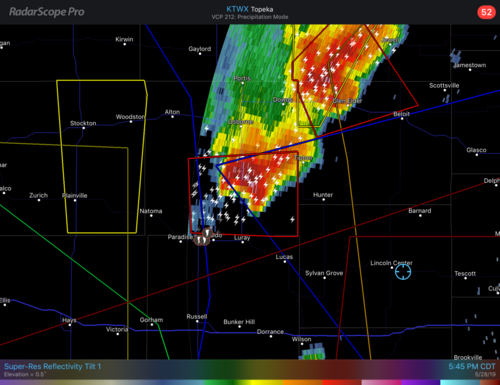
@Brett Nickeson thanks for the info. That whole time I was assuming it was the northern storm because while on the southern storm I thought the couplet actually looked better on the northern one. But now I see that I was simply way too late to the party. By the time I got to the southern storm, the Waldo/Tipton tornados had already occurred. Maybe the northern couplet was actually better by the time I got to the southern storm, but that was after the fact. The SPC TOR reports range from 5:26 to 6:06 CDT for the Waldo/Tipton area. You can see in the image below we are still in Lincoln Center at 5:45.0D4EAB4A-5ABA-43D7-ACDF-95378078BB5B.png

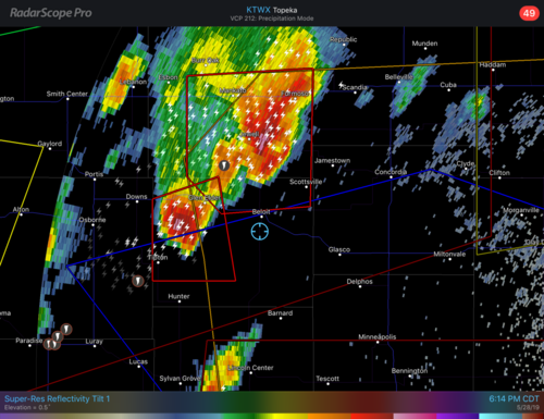
A half hour later, after the last TOR report, we are still just at Beloit and the southern cell is dying.

12B31204-A840-4B8C-8759-7DDC98A39801.png

Brett, if you saved any of the satellite images or other data you mentioned, would you mind posting here or maybe direct message me and let me know if you can send to me directly by email or something? Thanks!
 
One other question, SPC filtered reports show two Waldo TOR reports at 5:26, then a third at 6:06. But then there’s a Tipton report at 5:50. Doesn’t seem to make sense that there’s a Tipton report earlier than the last Waldo report. Any insight on that?
 
No idea. I do know that GID counted all of the tornadoes produced by that particular cell as one large tornado in their survey as there weren't enough DI's to even differentiate between them. May or may not have something to do with it.
 
Brett, if you saved any of the satellite images or other data you mentioned, would you mind posting here or maybe direct message me and let me know if you can send to me directly by email or something? Thanks!
I wish I had. It doesn't appear the mmm archive has the satellite photos from that day either. At least not yet.

EDIT: @JamesCaruso , Adam was nice enough to provide this screenshot in the reports thread. It roughly shows what I was talking about with the arcing dryline. The comma shaped small line of Cu over the two ASOS stations appeared to be the dryline. The southern storm traveled northeast roughly along it as it curved around the low.

35427_7b3771497e47d0df9d64fc44c1fa8285.jpg
 
Last edited:
I didn't chase the main target area on this event, due to having surgery the next day (I ended up doing some backyard chasing in IL that afternoon/evening). I had wondered this ever since this event and I'm not sure if this is the place to post it, but I wondered why NWS Wichita and Hastings have the Waldo-Lurray-Tipton tornado event listed as one single long track EF-2 tornado and don't mention any satellites or the fact that from the videos I've seen there were two primary tornadoes (The Waldo tornado that Adam Lucio has awesome video o along with Devin Pitts; which occluded and had a satellite), and then another large tornado that formed northeast and moved toward Tipton, KS that Pecos Hank and Skip Talbot videographed. It even appeared from their vantage point there were 3 tornadoes on the ground at once near Tipton, KS which struck me as rather extraordinary, especially how the far left vortex arced out of the main wall cloud and kinked around.

Screen Shot 2021-12-02 at 11.54.13 PM.png

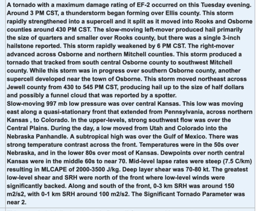
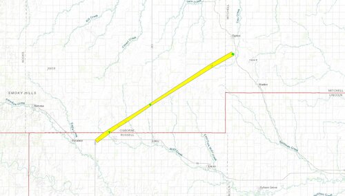
This is the piece written on the setup by NWS Hastings, along with the track map to go along with that.

KStor.JPG

Again I didn't chase this so I don't have any material of my own to contribute (maybe others can step in), but I've never seen a multiple tornado producing supercell like this get recorded in the NCDC storm data as a single long track tornado (in modern times, 2010+).. Just seems like the wrong way to document it. I had wondered this for over 2 years now and just thought if anyone else had any ideas the thinking behind this. Thanks!
 
I didn't chase the main target area on this event, due to having surgery the next day (I ended up doing some backyard chasing in IL that afternoon/evening). I had wondered this ever since this event and I'm not sure if this is the place to post it, but I wondered why NWS Wichita and Hastings have the Waldo-Lurray-Tipton tornado event listed as one single long track EF-2 tornado and don't mention any satellites or the fact that from the videos I've seen there were two primary tornadoes (The Waldo tornado that Adam Lucio has awesome video o along with Devin Pitts; which occluded and had a satellite), and then another large tornado that formed northeast and moved toward Tipton, KS that Pecos Hank and Skip Talbot videographed. It even appeared from their vantage point there were 3 tornadoes on the ground at once near Tipton, KS which struck me as rather extraordinary, especially how the far left vortex arced out of the main wall cloud and kinked around.

View attachment 22365

This is the piece written on the setup by NWS Hastings, along with the track map to go along with that.

View attachment 22366

Again I didn't chase this so I don't have any material of my own to contribute (maybe others can step in), but I've never seen a multiple tornado producing supercell like this get recorded in the NCDC storm data as a single long track tornado (in modern times, 2010+).. Just seems like the wrong way to document it. I had wondered this for over 2 years now and just thought if anyone else had any ideas the thinking behind this. Thanks!
I don't know why this tornado was poorly surveyed to be honest
 
Back
Top