• While Stormtrack has discontinued its hosting of SpotterNetwork support on the forums, keep in mind that support for SpotterNetwork issues is available by emailing [email protected].

2016-05-08 EVENT: KS//OK/TX/MO

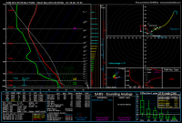
I think we might see scattered mid-60s by the evening but we're still right on track for the day. The FWD displayed a decently deep moist layer, larger than BRO or CRP this morning. Assuming this lead impulse leaves behind some residual cloud cover to start, our moisture might not crater out as badly with the higher SFC temps needed to coincide with our jet maxima to break the cap.

257607d668a2f7fb9fe35cad86f7c31f.jpg

Sent from my XT1080 using Stormtrack mobile app
 
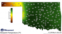
Not chasing but looks like Altus/Lawton area might produce. HRRR been somewhat consistent with this supercell complex. Some agreement with the HRRR and NSSLWRF. Dews are near 65F and I know there was some worry they would get into the mid 60s. Decent clearing too with HRRR suggesting 3000 j/kg CAPE. Veering profiles look decent. Good luck to those that are chasing down in SW OK.
 
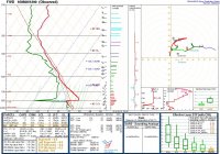
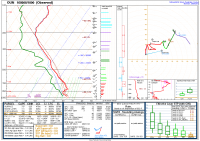
I'd be curious to see you guys feedback on this. I know there were some tornadic storms around in NC KS and SW OK, but after taking a look at the things prior to initiation (18Z soundings at OUN and DDC) it looks like there were a few things acting against the atmosphere to allow for a greater production of tornadoes. Initially, in reviewing the surface data, it looked to me like the surface flow, while backed, was mostly anemic. Additionally, I thought the winds and temps at H850 were a little on the weak side (20 kts). But after looking at those specially launched soundings, it looks like this was more of a VBV issue (S Shaped hodos) again, acting against tornadogenesis.

I ended up foregoing the 14 plus hour drive from Michigan initially because of my concerns with deep layer moisture, but after watching the SPC mesoanalysis page on and off throughout the day, I quickly realized that that wasn't going to be an issue, in turn causing me to question my decision.

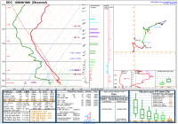
Below are the 18Z soundings from OUN and DDC:
OUN:
OUN.PNG

DDC:
DDC.PNG

Both soundings show a a pretty solid cap, we these were at 1PM locally.
What are your thoughts?
 
... I ended up foregoing the 14 plus hour drive from Michigan initially because of my concerns with deep layer moisture, but after watching the SPC mesoanalysis page on and off throughout the day, I quickly realized that that wasn't going to be an issue, in turn causing me to question my decision.

Both soundings show a a pretty solid cap, we these were at 1PM locally.
What are your thoughts?

I can't chase as much as I used to owing for family reasons, and I opted to sit this one out despite being in the Oklahoma City area. By yesterday morning, model forecast wind profiles were going down the tubes (no pun intended), which played heavily in my decision to "save up" my chase days (hey, I'd have to use a lot of familial political capital to ditch my wife and son on mother's day after being out of town for a week ;P ).

The shear profiles were unremarkable despite, as has been the case several times so far this spring, earlier model forecasts of strong low-level shear. A weakness in the flow around 700-750 mb and, in perhaps a few small area, a veer-back-veer vertical wind profile yielded S-shaped hodographs that looked unsupportive of significant tornadic supercells. [As Jeff notes below, you don't necessarily need veer-back-veer to get an pseudo-S-shaped hodograph. In this case, the weakening of the flow from ~850 to ~700 mb was the nasty part, IMO). Indeed, in the entire risk area in Oklahoma, there was only a single, briefly tornadic supercell. For the most part, left-moving, anticyclonic supercells were preferred over the right-moving, cyclonic supercells; there looked to have been more negative SRH for left movers than there was positive SRH for right movers. Looking at the hodographs across central and western Oklahoma, this is not surprising. The zone of strong destabilization and weakened CINH was also not particularly large owing to the cloud cover that persisted across much of central Oklahoma.

@Jeff Duda posted the following on Facebook (I don't think he'll mind me posting it here since it's weather related), which is the hodograph based on the FDR VWP/VAD valid a little after 22z. "Blech" in terms of a significant tornado threat... (Click any of these thumbnails to enlarge)
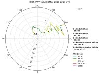
13178701_10103762017324069_6490090126955183529_n.jpg

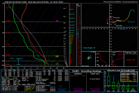
Below is the 00z OUN sounding, which wasn't that far from the briefly tornadic supercell east of Lawton. Note that there is only cross-wise vorticity above 1 km AGL. As was the case a couple of weeks ago, the 0-1 km SRH wasn't too bad, but the 0-3 km SRH was on the low end for supercells. Not too that the cap was going to quickly devour any surface-based storm that approached the I35 corridor, which is pretty much what happened (note convective temperature of 89 F where surface observations showed 2 m AGL temperatures in the low 70s).
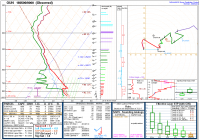
20160509_00z_OUN_sounding.PNG
If we go into model analyses to look a little west of the I35 corridor to get closer to the storms, we see hodographs that are no better... Example below from the 00z NAM analysis for a location near Lawton (first image) and somewhere between Alva and Coldwater just north of the OK/KS border (second image):
nam_2016050900_000_34.84--98.05.png

nam_2016050900_000_36.28--97.92.png
 
Last edited:
Robert,
IMO, the failure mode of the day was actually early initiation of storms coupled with 'S'-shaped hodographs. There wasn't much actual veer-backing going on, as 500 mb winds were past 225 degrees. However, you can still get the "S" shape without veer-backing.

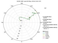
What I mean by early initiation is that models (especially the flavors of the NAM) suggested it wouldn't be until close to 00Z that the wind profile would become very favorable for bigtime storms and tornadoes. A lot of 21Z soundings across the region had 'S' shapes. See the below VAD derived from KFDR just after initiation:

KFDR_VWP_2102.jpg

Note the '+' indicating right-mover storm motion at the time - it's on the wrong side of the hodograph if you're looking for cyclonic rotation! The left-mover storm motion was around 205 deg. at 45 kts. Anyway, this hodograph was much more friendly for left-movers, and those are the ones that tended to survive. If storms had fired a few hours later and the wind profile had matured into the classic hooked shape (it did appear to get better towards 00Z), I bet this event would've resulted in quite a few more tornadoes. A look at mesoanalysis yesterday showed that 700 mb flow was less veered once you got to the TX-OK border and westward. And the dryline had begun to retreat as early as 21Z from what I judged by watching a radar fine line from KFDR. So later initiation would've also meant storms would have developed a little further west, closer to the region with a better wind profile (and with overall better wind profiles warm-sector wide). The Lawton storm was able to produce a tornado because it turned hard enough to the right to make the storm motion vector on the correct side of the hodograph (it was moving basically due east once it got organized).

Regarding the 18Z soundings you posted: Norman was generally too far east to sample the true environment these storms were living on, so I wouldn't put much further consideration into the OUN sounding. Also, there was a strong cap on the 00Z OUN sounding, stronger than forecast. However, widespread clouds during the day across C OK also limited destabilization and narrowed the warm sector, which is why the Lawton storm died as it moved into Stephens County. The veer-back in the 18Z DDC sounding is not all that bad even though it was low in the profile. However, the hodograph on the 00Z DDC sounding was much improved and would've supported intense storms had the thermodynamics worked out.

Overall the moisture ended up not being an issue at all, which surprised me. Surface flow was also not a problem: winds of 10-15 kts out of the SSE and even SE/ESE were common throughout Oklahoma during the afternoon.
 
Last edited:
Excellent discussion, Jeff. I agree completely. I was relatively confident we'd get a few nice tornadoes on the dryline yesterday up until mid-afternoon or so, because as you mentioned, earlier guidance had suggested initiation would be well timed around 22-23z. Instead, the main round of initiation occurred between 20-21z, something that CAMs had already begun to suggest by the night prior. This timing in relation to SRH ramping up was a subtle detail probably overlooked by many at the time, including myself.

Had these initial storms held off until even 90 minutes later, it might have been a much different chase day. It's hard to say, because soundings/VWP and storm behavior yesterday suggested that the wind profile in W OK may not have been particularly favorable up until right at (or even a tad after) 00z. As the first storms were initiating around 3:30pm, I was looking at 850 mb wind forecasts from the HRRR and noticed that it consistently failed to ramp up the LLJ beyond 15-20 kt until right at 00z, which was immediately discouraging. Even at 23z, the HRRR showed very anemic 0-1 km AGL shear.

Due to the capping issues over much of OK and lingering cloud cover that held temperatures E of US-281 in the 70s, there was a relatively narrow east-west corridor for storms to intensify and mature. The strong midlevel flow and associated fast easterly storm motions (for right movers) compounded this problem. However, that corridor from Frederick to Cordell to Seiling eastward to US-281 might have been able to produce some nice tornadoes had mature storms entered there at 00z, instead of 21-22z. And not to be too much of a downer, but this more favorable timing theoretically could've had a positive feedback, where one or two right-moving supercells established a very strong internal VPPGF to sustain themselves further E into the more capped environment. The fact that a few early afternoon runs of the HRRRX depicted a dominant supercell surviving past I-35 in the evening with high UH is some evidence for this.
 
I was surprised that there were more TOR warnings and reports in northwestern KS. IIRC, surface temps and dewpoints were much lower there. What was more favorable in that region?
 
I was surprised that there were more TOR warnings and reports in northwestern KS. IIRC, surface temps and dewpoints were much lower there. What was more favorable in that region?

Hodographs lacked the S-shape up there. Thermodynamics were the 'scaled' same (may have been somewhat cooler and drier at the surface, but it was also cooler aloft, so lapse rates were still pretty good and MLCAPE was also as high as it was in OK).
 
Back
Top