11/12/05 Reports: Central Plains

Joined
Apr 18, 2005
Messages
207
Location
Norman
Well, this is a report relayed from Jim Bishop and Mark McGowan from Central Iowa:

-witnessed 4, but maybe 5, tornadoes
-large hail; no confirmation on size yet
-multiple low-topped supercells (no confirmation on number yet)

-witnessed thin white-rope tornado early
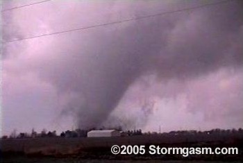
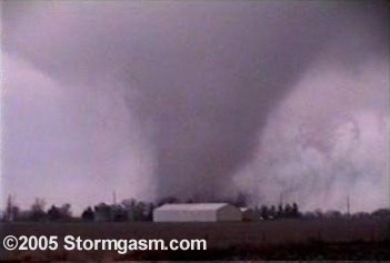
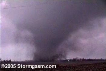
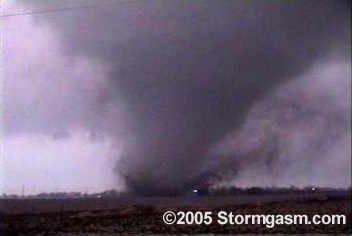
-violent cone tornado with debris documented near Gilbert, IA
-1 or 2 more brief touchdowns between Gilbert and Roland, IA
-a brief touchdown ~6 miles NNE of Roland, IA near dark

This is the most accurate information given at this time; hopefully video and photos will be added over during the next few days.

Simon Brewer
 
Was on what turned out to be the southern most cell all afternoon. It was no easy feat. It looked close to tornadoing before it got to the interstate then struggled for a while. I met up with Steve Peterson at the highway 25 exit on I-80 and we kept after it. Somepoint further ne we were right behind the updraft and it was simply amazing. One of the most amazing sites of an updraft I've seen, with a tight notch into it and it was quite low...quarter sized hail all over the road. It sucked there was just no stopping to take better stills of this. After messing with Minburn and some slow traffic after there we saw the tornado form to our east. It was big right away and looked quite violent. We blasted east on 141 and it crossed the highway ahead of us. It kept looking violent. Right there cops are flying by us and we all get to swerve around piles of hay or some crop all over the highway. Right after that we saw a heavily damaged house with people in the yard and the cops went up the drive way. The rescue services seemed really on the ball as they were all over as it was happening. We kept going and gained some ground on it as it coned out a bit. It had been a big fat barrel all along(this is the same one on that Madrid web cam). So we turn north towards Woodward as it finally ropes out. We were then stopped due to debris all over the place on the south side of town. And if you stopped once on this chase your chase was over. The structure was really damn nice at this point too(to our ne). It now had this long beaver tail that was actually pointed straight se.

It looked like it made quite the mess and I hope somehow no one was seriously injured. The good thing was when it got to Woodward it was roping out and much much smaller. I'm pretty sure this was the first time I've witnessed any severe damage from a storm I was on. I was surprised just how far south we kept seeing emergency vehicles going north after this.

Dean Cosgrove was also on this storm I believe. I'm pretty sure he was ahead of me north of Minburn. Pics and whatnot will be online later.
 
What a sad night, i was on the storm that ahd hit the Stratford IA area and Stanhope, i however was on the end i didnt get to see the tornadoes, but the damage was real and it makes you think, i feel so bad right now for people, they found one womans body in stratford im still in shock as i have never experienced anything like this whatsoever now i just think appreciate what you have because it can be gone in with minutes or seconds, after the tornadoes had gone through i was helping out some people in the area, i had this 5 year old girl in my arms crying for help and i borke down into tears i felt so bad and didnt know what to say but just comfort her.... its just so sad to see houses destroyed and tree's uprooted, i heard alot of reports while headed home that 5 houses were destryoyed. by far there was much more done, and i can only imagine what daylight will bring but destruction, chase wise i never expected this, it was the cell that blew over me and then went north, kind of slwoed down and started producing hail, as it got into boone county up taht way all i heard was reports.... i hope this never happens to any of us ... i took some pics of the clodus and stuff but just as respect i dint shoot any video of damage or take pictures, i was so depressed with sadness and a little bit of anger i talked to one of the sherrif's and he said how did this happen, and i told him it wasnt supposed to happen like this... he said to me in my years of being an officer hear never woudl i have imagined this...

my hopes and iwshes goes out to these people tonight, i wish them the best and EAS and emergency management came through big, from webster city, boone, and ames... i cannot even know what you guys go through... but tonight was a real experience for me firsthand but sad...


and i cannot totally take this in yet. :cry:
 
Initially I decided (Along with Mickey Ptak) NOT to chase as everything was going to be to far to the East and late evening (DARK) storms. Well, about 2:30 a friend called and said he would spring for gas and so I went.

There was a narrow band of low level clouds moving east from about Pawhuska when we started out. Noth really exceptional, just a low level set of very low topped Cu. We were basically behind the power curve for most of this chase and floowed these coulds along the Kansas line to US 75. Here we started watching a few towers that were attempting to go up further to the north and decided to go on up to Independance, Ks. and then continue east from there. Once on US 169 we figured the error as storms were starting to fire further south into Oklahoma. Got on US 160 towards Altamont, Ks, and then a KS highway south back to US 166 through Edna. From here we continued through Chetopa where a SVR went out on the cells near Commerce, OK. Took off south a little ways as the storm moved over the area. 50 mph winds, lots of rain and nickel hail were the menu. Moved back north and off the Baxter Springs, KS and stopped to really take a good look at what was happening. Being it was getting fairly dark, it was hard to really see. However, we spotted a wall cloud to the SE and moved to intercpt this. As this feature moved over the MO line, a TOR went out. Oh man, this area is hard to chase in. Trees, Hills, lots of rain. Roads that lead nowhere, I-44 was an option, but I really wanted to stay off it if possible. Down in the toolies south of Joplin (Shoal Creek area) we finally lost sight of the Wall cloud with the afore mentioned obstacles. Had several close lightning hits with on about 100 yds away. No real wind to speak of and then there it was! Nope, not a Tornado, but some pretty serious winds at about 70 mph.

Several things came to light for us here. One, it was too dark to really see much except back lit by lightning. Two, we were in the rain and anything that would have formed would have been rain wrapped so we wouldn't see it. Three, we were in very close proximity to the warned Meso and had lost sight of it. OK, now it's time to back out. Finally got on I-44 and went a little further east hoping for a clear slot where we would be able to see the clouds and find out what was happening. Other than local radio reports we had no other information to go on. We gave up the chase just east of Joplin and returned back home via US 71 and US 60.

Nice little chase and certainly something for the middle of November!
 
Followed the same band as John but from the south side. I wanted to stay close to it's progresion and also still have an option to head east-southeast towards Arkansas. By 4:30 some growth provided the hope needed I ended up coming into Missouri on hwy 10 then up 43 ? towards Joplin. I had let the storm get way ahead when I had stopped to get some lightning shots south of Miami. When it was severed warned it was time to catch back up . I was somewhere just south of Joplin when I finally found a radio report that it was torn. warned and was headed for Diamond now what threw me was it was also described as being 11 miles east of Joplin, which doesn't make sense since Diamond is southeast of Joplin on hwy 59 and hwy 59 is less than 11 miles from Joplin .. oh well here is a few pics and a couple video grabs

img0020.jpg.w300h225.jpg


img0053.jpg.w300h225.jpg


img0070.jpg.w300h225.jpg


Video Grabs south of Joplin


?
neoklahoma1122005181.jpg


neoklahoma11122005191.jpg


More pictures here
 
Sorry to hear of the damage and havoc in Iowa last night. But good work to all on the intercepts up there yesterday - - - not as exciting to the south. Didn't stick with the original target, and decided to shortcut, which never seems to work out as well. Still made for a nice diversion on a Saturday afternoon in November ...

Looked over data in St. Joseph with Dick, Darin and Erin - and could see the storms going up in SW Iowa on satellite and radar, but it was too late to head north, so decided to stick to the south and hope for something closer to home. Storms had trouble initiating to the south, but we managed to keep up with a cell that had originally formed south of St. Joseph, then reorganized over Cameron. We pursued it north as it moved over the winding Missouri roads at 55 mph and developed a nice, broad rain-free base/inflow. The storm developed a couple of lowerings and a decent notch at one point, but just could not manage to attain a level of severity, as it appeared to finally race ahead of the convergence axis. Storms to our west and south became better after nightfall and began to generate some decent electricity. The storm to our west (in between Maryville and Bethany apparently at the time) had a bit of an overshooting top for a bit as well and looked like it was probably healthier as the sun was going down, with better access to moisture.

Wed0089.jpg
Wed0098.jpg


Wed0116.jpg
Wed0122.jpg
 
Finally got a short video clip up (~10 MB)
Click on the link below to view clip:

http://www.stormgasm.com/11-12-05/11.12.05.4.WMV

The no pics or vid stills have been made yet, but we'll get some up soon.
Jim Bishop and Mark arrived in Norman around 6AM Suday morning; they were completely exhausted and are already on their way to Houston.

Simon
 
Here's a pano of what we were following. This was taken just west of Altamont, Ks. about 5:30 p.m. Had to do some real hustling to catch up here.

I have to agree with David, The areas given for the TOR were confusing. Diamond is indeed the opposite direction of what they were giving on the radio (Both Local and NOAA). However, using I-44 as the reference, we stayed out of trouble.

52232607.jpg
 
What a chase. Mark and I left Houston Friday afternoon and were on tornadoes in Iowa Saturday afternoon. We made it back safely to Houston late Sunday night. I'm completely exhausted but that's a small price to pay for an incredible tornado. I'll post a chase summary on the website soon. Simon has helped out a bunch by posting the video and video stills here and on the website.
 
Awesome pics all! I was greatful for the nice structure I saw here in Norman at about 6pm on Saturday looking SE. No time to grab my camera, so you'll just have to take my word for it... :)
 
What a chase. Mark and I left Houston Friday afternoon and were on tornadoes in Iowa Saturday afternoon. We made it back safely to Houston late Sunday night. I'm completely exhausted but that's a small price to pay for an incredible tornado. I'll post a chase summary on the website soon. Simon has helped out a bunch by posting the video and video stills here and on the website.
What's your success rate on such long-haul chases? How often do you drive these incredible distances per year? I know I'd have to be really confident in my forecast before I was to drive halfway across the country and back in just a few days, but then again, I'm older and have more responsibilities now, and need to budget my time a little closer.
 
Hey Everyone,

Amazing how fast events unfolded in IA to make for a very intense and fast paced chase day. Initial storms were reported moving 75 MPH! Chase plan was to keep going east and catch next storm firing to the SW and racing NE. Base on storm moving into Dallas County, IA quickly lowered and the chase was on to try and keep up with this storm. The mixed feelings of excitement along with feeling sad for those effected when a storm I am chasing hits a town are hard to put into words. My thoughts and prayers are with those people. I was moved by the quick and impressive response to help the people in Woodward.

First shot is storm that would later produce the tornado

Nov_12.jpg


Nov_12_vid%20001.jpg


Nov_12_vid%20005.jpg


A few more tornado pics can be found on my site

http://windsweptchasetours.com/index.html

Mike Hollingshead has a more detailed account in case you have not checked it out yet . My chase adventure in Dallas County was very similar to his

http://www.extremeinstability.com/05-11-12.htm


Dean Cosgrove
 
Originally posted by Greg Stumpf+--><div class='quotetop'>QUOTE(Greg Stumpf)</div>
<!--QuoteBegin-Jim Bishop
What a chase. Mark and I left Houston Friday afternoon and were on tornadoes in Iowa Saturday afternoon. We made it back safely to Houston late Sunday night. I'm completely exhausted but that's a small price to pay for an incredible tornado. I'll post a chase summary on the website soon. Simon has helped out a bunch by posting the video and video stills here and on the website.
What's your success rate on such long-haul chases? How often do you drive these incredible distances per year? I know I'd have to be really confident in my forecast before I was to drive halfway across the country and back in just a few days, but then again, I'm older and have more responsibilities now, and need to budget my time a little closer.[/b]

I don't know what the success rate is, but it is not very high. As most chasers and forecasters know, forecasts usually change to a certain degree from 24-36 hours before an event to right before an event unfolds. This leaves ample room for error, or a bust. You always take a big risk on "long haul" chases, as you put it. But do that enough times, or be "hardcore", and you shall succeed.

I was confident things "could" pan out, but I also knew very well there was a better chance in it not panning out. It was a calculated risk - I knew there could be a window of opportunity for tornadoes. Plus I like to take chase opportunites when I'm off work (Sat & Sun). I guess you could say I just really wanted to chase!
 
Back
Top