cdcollura
EF5
Good day all,
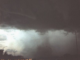
Here's my first really good shot from WAY back in July 1987 of a weak tornado north of Hollywood, Florida and crossing I-95. The un-touched picture's view is to the south.

Below is the chase-log entry for that same date (July 7, 1987)...
JUL 7, 1987 ... 6:00 PM - Penetration and interception of an extremely severe thunderstorm supercell and tornado touchdown along Interstate 95 in Fort Lauderdale, Florida. This storm was a rare classic supercell that contained large hail, unconfirmed public reports as large as baseballs, and destructive winds. The chase, accompanied by guest Tony Ihrig, went south along Interstate 95 from Pompano Beach to Fort Lauderdale. A punch through the western edge of the high precipitation core was executed where hail over an inch was observed along with 65 to 70-MPH winds, torrential rains, and continuous lightning with close hits. The rain free base was encountered near Fort Lauderdale airport where a tornado was observed about two miles ahead crossing Interstate 95. The rain free base contained a large wall cloud with strong mesocyclonic rotation. The precipitation even wrapped around the "bear's cage" forming a hook echo precipitation pattern as the tornado was touching down. Debris was observed from both the tornado touchdown as well as from the powerful outflow of the storm to the east. Documentation for this storm was still photos, including the tornado touchdown. Trees and powerlines were downed in this storm, with a roof torn off a home where the tornado hit. Hail damage and flooding also occurred under the worst part of the storm core. A 1984 Chrysler Laser was used to chase the storm, which was caused by extreme instability. An upper trough, surface trough, and daytime heating allowed this supercell to develop. The storm itself was over 20 miles wide and 67,000 feet high during its most active cycle.
Here's my first really good shot from WAY back in July 1987 of a weak tornado north of Hollywood, Florida and crossing I-95. The un-touched picture's view is to the south.

Below is the chase-log entry for that same date (July 7, 1987)...
JUL 7, 1987 ... 6:00 PM - Penetration and interception of an extremely severe thunderstorm supercell and tornado touchdown along Interstate 95 in Fort Lauderdale, Florida. This storm was a rare classic supercell that contained large hail, unconfirmed public reports as large as baseballs, and destructive winds. The chase, accompanied by guest Tony Ihrig, went south along Interstate 95 from Pompano Beach to Fort Lauderdale. A punch through the western edge of the high precipitation core was executed where hail over an inch was observed along with 65 to 70-MPH winds, torrential rains, and continuous lightning with close hits. The rain free base was encountered near Fort Lauderdale airport where a tornado was observed about two miles ahead crossing Interstate 95. The rain free base contained a large wall cloud with strong mesocyclonic rotation. The precipitation even wrapped around the "bear's cage" forming a hook echo precipitation pattern as the tornado was touching down. Debris was observed from both the tornado touchdown as well as from the powerful outflow of the storm to the east. Documentation for this storm was still photos, including the tornado touchdown. Trees and powerlines were downed in this storm, with a roof torn off a home where the tornado hit. Hail damage and flooding also occurred under the worst part of the storm core. A 1984 Chrysler Laser was used to chase the storm, which was caused by extreme instability. An upper trough, surface trough, and daytime heating allowed this supercell to develop. The storm itself was over 20 miles wide and 67,000 feet high during its most active cycle.


