• While Stormtrack has discontinued its hosting of SpotterNetwork support on the forums, keep in mind that support for SpotterNetwork issues is available by emailing [email protected].

What's keeping a violent tornado from hitting the Denver metro?

Joined
Mar 23, 2013
Messages
443
Location
Denver, CO
The F-4 tornado that hit Yellowstone National Park on July 21, 1987 has my brian churning with questions.

The Yellowstone National Park F-4 Tornado

The park's lowest elevation is 5,282 ft (2 feet higher than Denver) and its highest point is 11,358 ft. At one point the tornado crossed the Continental Divide at over 10,000 ft as an F-4.

So, what is preventing a major EF-4 or EF-5 tornado from forming and striking the Denver Metro or Salt Lake City?

We almost had that precise scenario occur there on June 22, 2023 when a rather large tornado formed in Highlands Ranch, CO (SW side of the metro). None other than Reed Timmer was there to capture it.


Thankfully the damage was limited and the tornado was only on the ground for 6.3 miles and received an EF-1 rating from the NWS in Denver.

But what if it had stayed on the ground, ramped up and hit a lingering outflow boundary or hit a more unstable air mass? Is an EF-4 or EF-5 possible in the Denver metro?

I'm curious as to how it couldn't be possible considering a true F-4 hit Yellowstone NP and did F-4 damage at over 10,000 ft.

I should also say, I am in no way saying I would ever want this scenario to occur. My curiosity is just piqued from a scientific standpoint.
 
Colorado hasn't had an F/EF 4 or 5 in the period since SPC records began in 1950, save for an EF4 on May 18, 1977 that actually started in the Oklahoma panhandle and crossed over into Colorado. Some tornadoes that occurred in Colorado before 1950 could have potentially been F4/F5 rated, most notably the August 10, 1924 Thurman tornado (link) which has been notionally rated F4. I assume that high-end tornadoes aren't common here due to a lack of quality moisture, but I'm sure someone could provide a more nuanced answer. Given the occurrence of the Yellowstone/Teton F4 it seems that an EF4 tornado is theoretically possible in the Denver area but we've yet to see something like that.

However, F/EF 3 tornadoes are somewhat common in Colorado and have actually occurred in the Denver metro, most notably on June 15, 1988. There is some great info on this and similar events at this link. The formation of these tornadoes was likely associated with the DCVZ, which usually sets up just east of Denver or sometimes over it. As the population of Denver grows and the sprawl spreads eastward, I imagine many more people will be building homes directly under the DCVZ, making such an event more likely in the future. We even saw damaging EF2 tornadoes very close to Denver on May 18 of this year.

The best analog for a damaging high-end tornado near Denver is probably the Windsor EF3 tornado of May 22, 2008. This tornado proved that damaging, long-track tornadoes can occur very close to the Colorado front range. Most people that live here seem to have a misguided belief that tornadoes do not happen in Colorado, or that they are uncommon, both of which are not true even for the Denver area. A study of the Windsor tornado by Schumacher et al. in 2010 details the occurrence of F2+ tornadoes in Colorado and Wyoming (link, go to pages 7-9 of the pdf or pages 1418-1420 in the original journal). Essentially, F/EF 2+ tornadoes were found to be relatively common near the front range, with the 2008 Windsor tornado not appearing to be an extreme outlier when looking at the broader historical record. Based on this information, and the occurrence of DCVZ tornadoes rated F3, I believe that another EF3 will probably occur in or near the Denver metro at some point this century.

However, I would argue that the Yellowstone/Teton F4 was an extreme outlier, and its occurrence only indicates that an EF4 is possible near or in the Rockies, but absolutely not that one is likely. It is interesting to consider the prospect of an EF4 tornado in Denver but I'd bet that we won't see one anytime soon. Hopefully.
 
So, what is preventing a major EF-4 or EF-5 tornado from forming and striking the Denver Metro or Salt Lake City?

Nothing, other than probabilities and randomness. The area outside of Denver (or any major city) is much, much larger than the area within it. So a tornado is much, much more likely to strike outside Denver (or any major city) than within it.

I think I read somewhere that the odds of a tornado hitting any given spot on the map is like once in 2,000 years.
 
Low dewpoint, low CAPE, minimal LLJ will tend to keep tornadoes on the low end no matter where they happen. Colorado is high and dry relative to where the real large moisture, cranking LLJ, etc. tend to come together. Also while tornadoes can happen on top of mountains, and in the foothills, there are stablity affecting rotors and up/downslope winds that interfere in various ways with storms so it is not common. It is more rare to have a large supercell right off the mountains not because it can't happen, but because the ingredients rarely sit that far west and if they are, do not remain undisturbed by orographic effects, mixing out with drier mountain air, etc. If you look at tornadoarchive or other tornado maps, tornadoes this far west are often brief and weaker than the long track and more violent variety found in the flatter and wetter states.

Denver metro scrapes together enough ingredients for F0/1 somewhat frequently, and sometimes up to F3, such as Longmont a few years back, Windsor in 2008, etc. The plains fairly often have EF2 or EF3 events, starting right at the I25 corridor and typically intensifying the more east you go. Colorado is about as empty as KS if not more so in the plains, so who knows without damage indicators what some of those tornadoes really are, but they certainly do not often have the look of monsters found further east or south.

Salt Lake City has had en EF2 go right through downtown. This could certainly happen in Denver, but supercells are rare in both locations, even more so in Salt Lake.

So in summary, it could happen, but would be a fluke at least as much as Yellowstone. Note Yellowstone has plains where powerful tornadoes happen not far to the west. Denver just has more mountains to the west where it is possible but not likely to store supercell ingredients, and storms only ocassionally move east to west here (very rare actually). In a flat area with great veering wind profiles and tons of moisture, it is much more likely for strong tornadoes to occur, and that just isn't Colorado as often as it is KS/OK/TX/LA/TN/NE/IA/etc....
 
I did a project shortly after the Windsor tornado in 2008 where I took the path and dropped it 50 miles south and ran it through the heart of the Denver Metro area. A similar question was pondered as part of that project, and it was speculated that the Windsor tornado could've been rated higher in the Metro area as the chances of observing EF-4+ damage would've been higher with more to impact.

I think it's just luck, honestly. Windsor showed that while incredibly rare, large strong/violent tornadoes CAN indeed occur along the Front Range. I do think Denver gets a little help with the mountains being so close so most storms with an eastward trajectory tend to be higher based coming off the mountains, so unless there is a good pool of higher dewpoints to bring the storm bases down quickly, anything strong from those typically would need some time to fuel up (in theory). Windsor was a rare case as this storm was moving northWEST as opposed to the usual easterly direction, so it formed in an area of better moisture first and thus moved toward the Urban Corridor from those higher dews..

Obviously the areas east of Denver are hotspots for tornadoes, but usually for the weaker, landspout varieties with on occasional supercell tornado, but those typically happen further east and then move away. I think a scenario like Windsor would need to occur again where you get a bonified supercell to develop east and then move WEST back toward the Front Range with an organized mesocyclone to have a chance to produce a strong tornado. Or something very slow develops along the Front Range and thus has time to fully form over the Metro and drops something then.

I've often wondered, in terms of more landspouts hitting within the population centers of Denver, if the friction at the ground decreases landspouts (as they tend to form from the ground and get lifted into a strongly developing updraft). The metro has expanded east, well within 'landspout alley' (I just made that up), and I feel as if there should be way more hits now because of that, but I question whether the ground dynamics are interrupted a bit, thus reducing landspout potential verses otherwise more less developed areas (and that may offer a theory why Denver doesn't see more landspout impacts).

My two cents...
 
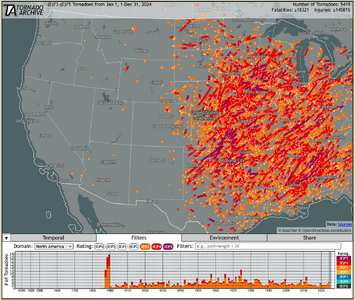
Here is a screenshot using the browser from tornadoarchive.com. Filtered at EF3 and above for all records going back to the late 1800s. Note that violent tornadoes are much less likely the more west you go, and shorter tracked in time/distance when they do happen.

I think this picture does a better job than my previous explanation showing that the ingredients are simply rarely in place this far west for strong tornadoes. Yes, it could happen, but it would likely be a once in a century or more event to get an EF4/EF5 out west coming off the foothills. I find it impressive that Dallas has escaped an EF4/EF5, as have several large metros in Dixie Alley, which in my opinion would be the scariest place to live due to nocturnal HP monsters.

Screenshot 2025-06-13 094230.png
 
In the map Dave C posted: Note the 'hot spot' north of Denver with multiple tornadoes.
Weld County. The most tornado-prone county in Colorado.
Thats there due to the lay of the land and (a big factor) the "Denver Cyclone"/DCVZ.
Denver Cyclone's tend to setup east of Denver, (they form there due to how the land is laid out:: Rockies to the west, Palmer Divide to the south, Cheyenne Ridge to the north, and open to the east...combine those land formations with southeast low-level flow, and you have a setup ripe for rotation. (add higher level west or northwest flow coming over the mountains & it strengthens it)

So you have counter-clockwize flow circulating around the area outside Denver, and that area to the north is where the easterly low-level flow( which ofcourse pulls in warmer/more moist air) hits. Basically the central/southern Weld County is the "sweet spot" (areas west of Denver end up with more northerly flow thats a bit cooler/drier, so less chance of strong storms)
 
Back
Top