cdcollura
EF5
Good day,
Jason, thanks for the post / You-Tube link. His time lapse can be seen from 0:15 to 0:23 in the video. Amazing stuff.
Wesley, I was chasing with Jason as well on that storm, along with a group of others (Jeff Gammons, Amos Magliocco, and Steve Miller).
The storm was so small, I'll refer to it as our "ZP" storm, that I am not sure of any RFD / FFD. I have also seen larger "LP" cells, with no evidence of such (RFD / FFD) so maybe there was one of such but too small to discern from our vantage point.
Despite the strong updraft, and amazing horizontal slanting of the updraft from the shear, I think your assumption of air from the 800 / 1000 MB levels being drawn into the cell are correct, negating any downdrafts. Also, lack of precipitation loading will cause a lack of a downdraft, as the entire cell is completely inflow dominant, more so than an LP storm, and nearly steady-state during it's life-cycle, before shrinking.
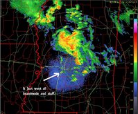
This storm (or cloud?) was on May 22, 2003 near Studley, Kansas (Sheridan County). It developed in a storm environment marked by high instability (CAPE) and shear, but surface dewpoints barely in the low-mid 50's. Boundary intersections gave the boost to overcome the cap and LFC, but the storm instantly shrunk after the sun got within 5 degrees of the horizon.
Also, a thing to note is that there was another cell (which also appears in Jason's TL video after 0:23) was practically next to the rotating previous "ZP" cell after it weakened and showed almost little or no shear / rotation. I assume a local speed-max or "jet-let" was above the "ZP" storm and not over the new one to it's west afterwards.
Below is my chase log entry for this storm, which can also be found at the link here: http://www.sky-chaser.com/mwcl2003.htm.
May 22, 2003 - 7:30 PM ... Observation of a small but fully rotating LP (and low-topped) supercell storm near Studley, Kansas north of highway 24. This storm was not penetrated but assumed to be a strong thunderstorm. The storm had a tight, LP structure with low-top and rotating low-level meso with the "stacked-Plate" effect, just very small! The storm lasted for about an hour and a half after becoming detached from a multi-cell storm cluster. A 2003 Chevy Blazer was used to chase the storms. Documentation was still photos and a camcorder. Surface heating, a convergence boundary, and high speed / directional shear environment with limited moisture caused the storm. A severe thunderstorm watch was also valid for the area until 11 PM, CDT.
My 2 cents worth,
Jason,
That was unreal. Although I've seen some LP's that were not too big, that one takes the cake. I'm not sure if it was a Supercell, but I tend to think it had all of the ingredients except for size. It definately had a strong updraft and inflow. But did it have RFD or FFD? Or did the minute size of it allow the air that rose to be replaced by air from 1000-800mb? Forgive me if my questions seem stupid, I'm still learning.
Jason, thanks for the post / You-Tube link. His time lapse can be seen from 0:15 to 0:23 in the video. Amazing stuff.
Wesley, I was chasing with Jason as well on that storm, along with a group of others (Jeff Gammons, Amos Magliocco, and Steve Miller).
The storm was so small, I'll refer to it as our "ZP" storm, that I am not sure of any RFD / FFD. I have also seen larger "LP" cells, with no evidence of such (RFD / FFD) so maybe there was one of such but too small to discern from our vantage point.
Despite the strong updraft, and amazing horizontal slanting of the updraft from the shear, I think your assumption of air from the 800 / 1000 MB levels being drawn into the cell are correct, negating any downdrafts. Also, lack of precipitation loading will cause a lack of a downdraft, as the entire cell is completely inflow dominant, more so than an LP storm, and nearly steady-state during it's life-cycle, before shrinking.
This storm (or cloud?) was on May 22, 2003 near Studley, Kansas (Sheridan County). It developed in a storm environment marked by high instability (CAPE) and shear, but surface dewpoints barely in the low-mid 50's. Boundary intersections gave the boost to overcome the cap and LFC, but the storm instantly shrunk after the sun got within 5 degrees of the horizon.
Also, a thing to note is that there was another cell (which also appears in Jason's TL video after 0:23) was practically next to the rotating previous "ZP" cell after it weakened and showed almost little or no shear / rotation. I assume a local speed-max or "jet-let" was above the "ZP" storm and not over the new one to it's west afterwards.
Below is my chase log entry for this storm, which can also be found at the link here: http://www.sky-chaser.com/mwcl2003.htm.
May 22, 2003 - 7:30 PM ... Observation of a small but fully rotating LP (and low-topped) supercell storm near Studley, Kansas north of highway 24. This storm was not penetrated but assumed to be a strong thunderstorm. The storm had a tight, LP structure with low-top and rotating low-level meso with the "stacked-Plate" effect, just very small! The storm lasted for about an hour and a half after becoming detached from a multi-cell storm cluster. A 2003 Chevy Blazer was used to chase the storms. Documentation was still photos and a camcorder. Surface heating, a convergence boundary, and high speed / directional shear environment with limited moisture caused the storm. A severe thunderstorm watch was also valid for the area until 11 PM, CDT.
My 2 cents worth,


 This was severe warned for two hrs. and was freakishly small.