What Caused the "Dead Zone" of Storms in North-Central OK on Sunday 2013-05-19?

JamesCaruso

Staff member
Joined
Jul 5, 2009
Messages
1,833
Location
Newtown, Pennsylvania
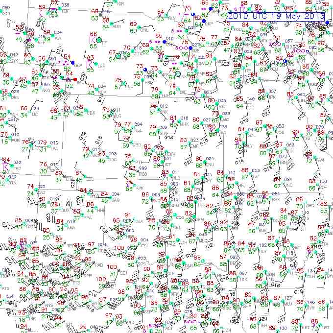
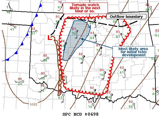
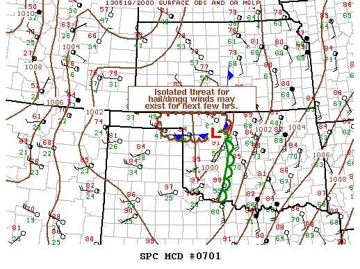
Look at the SPC tornado reports for this date and you will see a gap between the red dots in south-central KS and in central OK. This dead zone is the exact area we (regrettably) targeted, between Enid and I-35 to be exact. Not only were there no storms in this area, but the sky actually appeared to dry out and there were not even any cumulus. Meanwhile, it seemed that the triple point was just to our west (see images below). Enid was 86 over 72 with backed winds at 25, gusts to 31 (sfc obs below). I thought for sure we were in a great spot for initiation! Any insights on what happened?

Thanks to Eric Birch for thoughts he sent me directly in response to my chase report for this day, in which I asked a similar question. Looking for others' insights as well.
5ujuhymy.jpg

sa5ynupu.jpg

6ahypyga.jpg
 
Look at the SPC tornado reports for this date and you will see a gap between the red dots in south-central KS and in central OK. This dead zone is the exact area we (regrettably) targeted, between Enid and I-35 to be exact. Not only were there no storms in this area, but the sky actually appeared to dry out and there were not even any cumulus. Meanwhile, it seemed that the triple point was just to our west (see images below). Enid was 86 over 72 with backed winds at 25, gusts to 31 (sfc obs below). I thought for sure we were in a great spot for initiation! Any insights on what happened?
I'd like to know these things too! We first setup on hwy 81 just south of Kingfisher. As we watched the dryline clounds build...a tornado watch was issued for southern and se KS. We decided to drive north closer to where the dryline and cold front would intersect. While arriving in Enid the first twister touched down in north OKC. The 2nd tornado in east Norman missed my house by 4 tenths of a mile. It was a bitter sweet day. I redeemed myself on May 20th.
 
Two things went wrong. We were in the same area. Started out in Blackwell, relaxing over a sit-down lunch. Upon initiation in both Harper County KS and near Enid, OK we went west of I-35 to Pond Creek, OK to intercept the "Enid" cell. As Wichita tornadoed, we tried to forget that we based out of Wichita. Meanwhile "Enid" storm approached Pond Creek, OK. Behind it we saw another storm with a gorgeous barber pole and hook on radar. Unfortunately the front storm near Pond Creek cut off inflow to the back storm and barber pole. The front storm environment was more stable, so it was literally wasting inflow earmarked for the back storm. Inefficiency at its worst.

Anyway we jog north toward Medford, OK hedging our bets on the front and back storms. Eventually a wall cloud on the front storm can't be ignored as it lumbers across the Kansas state line. Between Caldwell and South Haven, KS we document a brief hose tornado that ropes out after less than 5 minutes. We had to see it through rain, out of position, but that's better than seeing nothing. Soon everything in Kansas lined out and tail end charlies failed all afternoon in northern OK.

Meanwhile the Shawnee tornado is being well documented, not getting rain wrapped, and cycling multiple times. Ditto from near Edmond east. We believe that two things went wrong. First, the northern cluster was inefficient. The storm in the best environment got cut off by a freeloader on the inflow. Net result was a poor use of available parameters/resources. Sure we saw a hose; however, better luck would have lead to a cycling elephant trunk and stovepipe show. Then the two beasts down near OKC (Edmond and Shawnee) destroyed anything to their north by cutting off the LLJ.

I'm not going to complain much because we booked a tornado. We did not see Moore, but we were "pre-redeemed" with the complete Rozel, KS show on May 18th. Saw both cycles start to finish, 3 tornadoes total including the double on the second cycle. You win some you lose some. Rozel made it an excellent chase trip!
 
We too targeted northern OK since there was a nice OFB floating near the state line. We had towers going up well south of Enid but nothing could stick. Up to the north though, the storm in southern KS was going nuts by early afternoon and we were still trying to get north. The storm that Jeff mentions was indeed a great example of a barber pole updraft. When the storm neared Wakita, it had the look of hitting stable air. We decided to bail to I-35 and make a decision...try to chase KS or head south where the Edmond and Shawnee tornadoes were in progress. We rolled the dice on the south, and went east of HWY 412, then south on 48. The storms by this point were massive HP messes, but still had an isolated look. After battling the hills and trees, much to our dismay, the storms weakened. I didn't forecast anything that far east, so I have no idea why these storms didn't keep ripping through the area. Here's what was left of the same storm that dropped the Shawnee tornado when we saw it in the sticks of OK

IMG_9197-XL.jpg


We caught up with the final storm near Okemah before it went outflow dominant. I'm assuming the shear wasn't as good the further east you went? What made the storms just die off so quickly? Were they running into stable air as well?
 
Upper (700mb-400mb) Subsidence can be a cause of this, and also poor 850mb moisture transport. Both are reasons why you'll typically see dryline outbreaks with 100-200miles between clusters of tornadoes.
 
Thanks for sharing your experiences guys. What made our situation worse is that we waited too long to adjust. I can't recall all the details quite as well now, but although we were near Enid we ignored the first cell that went up to our northwest, which I believe was the barber pole previously described, because it seemed to be behind the front, and that assumption appeared to be confirmed by an SPC MSD http://www.spc.noaa.gov/products/md/md0701.html We ignored the stuff in KS because, as I recall, that was a different setup (more on the synoptic front?) and we preferred the dryline / triple point play; besides, it looked like an elongated mess. We ignored the southern (and ultimately best) storms because we felt there would have to be others closer to us, that there was enough "room" for another cell or two to grow without interference.

Finally we knew we had to go after the southern cells, but the first one died as soon as we caught up with it in Drumright. We waited for the second cell to come to us, and it, too, died in Drumright! So that's another question, what was the storm suppression mechanism at play in that area?!?

Unfortunately, we were too patient today and should have gone after the southern storms right away. But we were trying to correct our mistake of the day before (5/18/13), when we committed to the very first storm that went up about 25 mi northwest of Spearville KS only to miss the later Rozel storm that came right through the same general area we had targeted!!!
 
Upper (700mb-400mb) Subsidence can be a cause of this, and also poor 850mb moisture transport. Both are reasons why you'll typically see dryline outbreaks with 100-200miles between clusters of tornadoes.

Rob, thanks, that makes sense because we did notice the sky drying out near us. Just another reason we should have bailed on our position much sooner.

Since you say this can be typical in dryline outbreaks, what is the mechanism causing this? Is it directly associated with this particular type of setup?
 
Subsidence generally occurs anywhere adjacent to areas of rising air. In rare occasions, you'll see a double-barreled vort max with subsidence in between, like on 5/24/11: http://www.spc.noaa.gov/exper/ma_archive/images_s4/20110524/23_vadv.gif

On days like 5/18/13, you'll have an impulse come out early and leave subsidence in its wake: http://www.spc.noaa.gov/exper/ma_archive/images_s4/20120518/14_vadv.gif

To be honest, most people catch the presence of subsidence *after* a chase.

850mb moisture return is a little easier to diagnose, but is commonly overlooked by people because most people don't learn about 850mb level processes other than the presence of an LLJ. To learn more about it, just look at typical dryline outbreaks or busts, and really dig into cyclogenesis and moisture return. Contrary to what most people say, SW 850s are not a bad thing - in fact, some of my best dryline chases have had either SSW or SW 850s. A lack of moisture at this level will spell bust for you, however. Here's an example of northward moisture return being deflected to the NE by strong 850 cyclogenesis, leaving a gap in between areas of ample moisture (think of the shape of the number "7"): http://www.spc.noaa.gov/exper/ma_archive/images_s4/20110524/19_tran.gif

edit: the moral of the story is, it could be these things, or any number of other things, but with dryline storms you can't just look at a model showing 3000 MLCAPE up and down the entire dryline, and the whole area in a 25% hatched tornado risk and assume the conditions are similar up and down the entire length of the dryline. There are differences that models will either not pick up or will smooth over and abstract away. You need to find the focusing of energy anytime you look for a target regardless of type of setup.
 
Last edited by a moderator:
Rob,

Would the subsidence you refer to originate from initial explosive convective development nearby (the focal point of which might owe itself to somewhat stochastic, storm-scale dynamics not picked up by the models) or is the origin of the subsidence more often synoptic in nature? In other words, does it depend intimately on storm-scale modification of the environment? In some ways, this is a sort of chicken/egg question (did storm initiation lead to subsidence, or did the subsidence shift the focus for storm initiation?).

I'm sure there's an either/or answer here, but I'm wondering if operationally one explanation usually trumps the other.

Paul
 
I seem to recall at the time that warmer 700 mb temps in eastern OK likely spelled the demise of the main show shortly after passing east of the I-35 corridor. Some MLCIN remained even towards 00Z.

As to why storms didn't form in the "dead zone" (which I also found myself smack dab in the middle of...just east of Enid initially)...I'm not sure sufficient data exists to answer that question. Deep moist convection is extremely sensitive to small variations in temperature and moisture content in the low levels. It could've been just enough dryness or coolness, perhaps even as a result of soil/vegetation conditions, to keep storms from forming. There could also have been a weakness in the wind field or a slight change in wind direction which would have resulted in slightly less convergence for upward motion. I doubt it was anything on the synoptic scale, as there really wasn't any obvious feature that would inhibit storms on such a large scale.
 
It was certainly a little vexing. I recall heading west on 412 into Enid before towers started going up to the north and noticing a very sudden shift in surface winds from a strong southeasterly component to strong southwesterly. I suspect surface convergence was not a problem...I even considered halting, turning around, and dropping south on I-35 toward the Perry-Guthrie corridor. But alas, the pit stop at the Enid Starbucks and free wireless to check on any new MDs suckered me in. Within a half hour of rolling into town I headed back out and raced south on 81 when the first few OKC updrafts were slamming into the tropopause. It's funny though, there were definitely some meager towers firing just over Enid, but considering their placement would have been west of the dryline, there was no moisture pool to tap into. Perhaps the moist side of the dryline closer to OKC hit its convective temperatures first with generally southerly warm air advection and intense insolation abound, which combined with the fantastic surface convergence must have put it over the top.
 
... It's funny though, there were definitely some meager towers firing just over Enid, but considering their placement would have been west of the dryline, there was no moisture pool to tap into. Perhaps the moist side of the dryline closer to OKC hit its convective temperatures first with generally southerly warm air advection and intense insolation abound, which combined with the fantastic surface convergence must have put it over the top.

Yes, I remember the towers there also and to the northwest of Enid, but ignored them because I thought the same, that they were west of the dryline. An SPC MSD said the same thing (see link in one of my other posts above). (However, one of those storms did have some nice structure for a time, based on the reports thread for this date).

Regardless, my big mistake was being stubborn about staying in my target area rather than racing off to the southern storms. That might have made sense if the sky had not been drying out like it was... I had been burnt the day before by committing to the first storm and chasing it north while missing Rozel, so I was trying not to make the same mistake again. I guess I over-compensated! :)

Jim
 
Back
Top