Tornadoes Hit Philadelphia & New Jersey 7/29/21

Mike, are you a member of the WAS-IS group on Facebook? It is a group that looks at the integration of weather and social sciences, and I think the points you are making would be of interest to that group. For others here with an interest in the relation of social science and societal issues to weather, I would also suggest that group.
 
John,

I used to be. However, I got off Facebook due to the sleazy antics of Mark Zuckerberg. The last straw was when he sent his employees into a hospital to attempt to break into a computer to get dirt and data on people.

I don't think this is a social science issue unless you mean "human factors" as social science, in this case "Why didn't they pull the trigger?"
The problem is that many in NOAA are in denial and I doubt they will be cooperative with a social science study. However, I'd love to be proved wrong.

Mike


Mike, are you a member of the WAS-IS group on Facebook? It is a group that looks at the integration of weather and social sciences, and I think the points you are making would be of interest to that group. For others here with an interest in the relation of social science and societal issues to weather, I would also suggest that group.
 
Social science would include analysis of organizational issues that could lead to less effective/timely warnings. Everything from organizational culture and structure to funding trends. For example, understanding WHY they reduced training and moved toward hiring people with less experience, if that is the case. So very much the domain of WAS-IS. Regarding Facebook, yes I have a lot of issues with them, too, but if you want to be on social media there are not a lot of choices. If I avoided every organization I have some disagreement with, I would have nowhere to go. ;-) Not trying to get too off-topic here, but I do think a discussion of why lead time for tornado warnings has been decreasing would very much be of interest to WAS-IS.
 
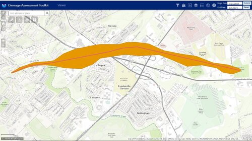
Here is a link to the damage surveys documented so far. I do not think this is completed yet, for example I don’t see the tornado that hit Long Beach Island (LBI) in the Barnegat area, causing damage both on the mainland and on the barrier island.


The image is the Bensalem tornado path (source - NWS Mt. Holly tweet via PhillyWX.com)

I still have that weird crappy feeling of missing an event as a chaser. Two tornados within a 10 mile radius of home!!! A once in a lifetime event even in Tornado Alley, let alone in southeastern PA!!! What a cruel irony to have been out of town. I could have theoretically seen the first tornado to my north and then still gotten down to Bensalem. Yes a tornadic storm did make it to LBI where I am vacationing, but it was after dark. Oh well, I guess even if I were home it would have been difficult to plot an intercept given the roads, traffic, buildings, trees, hills, etc. around here. I suspect there were a lot of low clouds, limited visibility, and little or no structure to be seen. I suspect most of the tornados were rain-wrapped, although I don’t know for sure. I haven’t seen too much in the way of video actually, but I haven’t looked too hard either. It was great to see the lightning over the bay and ocean; I would not have had that kind of visibility at home. I guess I have to just be grateful I’m able to chase the Plains and don’t have to depend on local events. I’m quite sure nothing on Thursday came close to what I have seen, or hopefully will see, on the Plains, so I shouldn’t be too worried about missing this, but still there’s got to be something incredibly surreal about seeing and experiencing something like this in your own backyard...

2600BD6A-FEE9-4B7E-B471-2B86B91C5EF0.jpeg
 
I still have that weird crappy feeling of missing an event as a chaser. Two tornados within a 10 mile radius of home!!! A once in a lifetime event even in Tornado Alley, let alone in southeastern PA!!! What a cruel irony to have been out of town. I could have theoretically seen the first tornado to my north and then still gotten down to Bensalem.
If it's any consolation, visibility here was terrible - there was a lot of heavy rain with those storms (in addition to the usual trees, buildings and traffic in the area) - and it's highly unlikely that you would've been able to get into position to see either tornado. The only video I've seen that appears to show the Bensalem tornado was taken with a Ring camera - 1:39 in this video:
 
Someone posted this link on PhillyWx.com. I’m sure many of you are familiar with this tool, but it’s the first time I have seen it.


While the Bensalem tornado looks like a damage path I would expect, others such as the New Hope / Washington Crossing tornado are a completely straight line, which can’t be an actual damage path. Any help with interpreting this map would be appreciated.

Also the Barnegat / LBI tornado is not shown on this tool or in the NWS Mt. Holly survey report. Was that determined to be straight line wind damage and not a tornado? Even so, I would assume the survey outcome would still be documented in the report...

@Lou Ruh I saw your survey participation mentioned in the report, any light you can shed on this (and further on-the-ground insights) would be appreciated!
 
To put it lightly, there's a lot of misinformation in this thread that needs to be clarified and checked. Not all of the comments below necessarily fall into that category.

but I always thought there was an algorithm that determines when the velocity couplet exceeds a threshold, so I’m not sure how there could be a deterioration in warning lead time, wouldn't this imply that someone was literally ignoring an alarm?? My understanding is that human intervention can issue a warning earlier than the threshold is exceeded, but not later ... But admittedly I don’t know too much about it, this is just my amateurish anecdotal understanding...
There are a couple of algorithms that have been developed over the years to assess the tornado potential of a storm. The only one that I know that is widely used currently is ProbTor, part of the recently developed suite of probabilistic severe guidance called ProbSevere. "Widely used" is a generous term, as I don't want it to seem that NWS forecasters rely on this algorithm (or any algorithm) to determine whether or not to warn on a storm. If they do, they shouldn't be on the warning desk. However, it is one of many useful tools that can help forecasters determine the severe/tornado potential of a storm. Nothing beats "manual" radar analysis, though.


In the preceding two minutes, the inbounds greatly increased. So, we had a supercell's pendant echo that was starting to grow a hook between Horsham and Abington and a rapidly increasing couplet (likely from an increasing RFD).
If you're an NWS warning meteorologist and you issue a tornado warning on a supercell because it has a hook/pendant in reflectivity, you'll at least be removed from warning duties if you're lucky. To be a supercell, the updraft has to be spinning, which is typically going to lead to a hook. Not all supercells produce tornadoes. As for the velocity data at 2249z, there is no couplet there. What I see is cyclonic convergence, which can (not always) be associated with tornadogenesis in the near term.


Given it was the "tail-end Charlie"
There is research that suggests a storm being the "tail-end Charlie" doesn't mean much for tornado potential. Interestingly, when the storm in question produced the tornado, it was no longer the tail-end storm, as another storm had formed in its updraft region, completely destroying any "classic" reflectivity signatures of the first storm. I believe this second storm produced the Bustleton EF0 that crossed Highway 1 and produced a hell of a debris ball for that weak of a tornado.


with a SIGTOR of 2
There is also research that shows the unreliability of STP during the warm season.


it was a pretty easy warning. That a warning was obviously needed became even evident in the next few minutes as the Bensalem supercell was clearly a right mover.
Given all that was said above in addition to there was not really much of a well-defined, gate-to-gate couplet prior to tornadogenesis, no, it was not a "pretty easy warning". TPHL provided a little better of a look at the couplet, but both it and KDIX looked to be plagued by glitchy level II velocity data. TPHL did show what may have been a low-level current of air emanating from the forward flank toward the mesocyclone, which research has recently picked up on possibly being a pre-cursor to tornadogenesis. Also "a warning was obviously needed became even evident in the next few minutes" - hindsight is 20/20. This is a terrible bias we has humans have when reviewing past events. Of course it was evident - it happened. This train of thought can lead to poor decision making and missed opportunities to properly learn. There are many books on this topic and how to think probabilistically. Here's a good one.

Some NWS offices rely more heavily on various techniques and algorithms
Techniques...yes. Any time you issue a warning, you've applied a technique to do so. It's a matter of if an office (forecaster, really) is up on all the latest and greatest research...or if they're still several decades back issuing warnings based on hooks in reflectivity. Algorithms....just no.


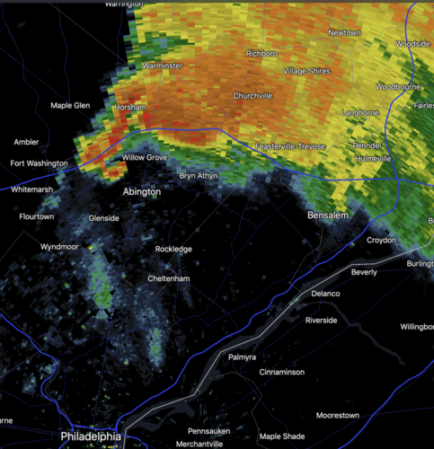
The retirement of my generation of meteorologists and our expertise. This is especially true since we learned to warn tornadoes based on hooks, right-movers and other non-Doppler wind techniques. Given the funnel cloud report at 6:49pm along with the hook (see image) west of Bensalem at 6:47, it would have been an easy warning even without Doppler.
I've seen horrendous warnings produced by folks of your generation. Experience does not always equal expertise. Again, if you put a tornado warning on a storm just because it's a right mover and has a hook, you're going to be taken off the warning desk in today's world. Also, the number of false funnel reports far outweigh the real ones. Good luck going solely off that and how a storm looks in reflectivity.


The hiring of meteorologists fresh out of college. I am aware of multiple instances in three months where the NWS hired meteorologists who graduated in May, even when a more experienced candidate had applied.
As someone who graduated in 2019...oof. What the hell are fresh college grads expected to do? This sounds like the classic "Needs 10 years of experience" for an entry-level job. If you think that newly hired NWS mets hit the forecast and warning desk on their first day, you are very mistaken. It takes YEARS of training. Also, coming from someone who generally lacks confidence in many things (I don't know if I'm even good enough to have imposter syndrome ;)), I can say confidently that there are times (not all the time) when I can out-forecast and out-warn people who have been in the business longer than I've been living. Again, experience does not equal expertise.


Degradated radar training in the NWS. A person currently in the NWS, when discussing the tornado warning problem said to me, "Twenty years ago, radar training was a month in Kansas City. A decade ago, it was a week in Kansas City. Now, it is a couple of hours from the SOO." I don't know whether this is true everywhere or in all cases. But, if it is largely true, it is a serious issue.
Your source is either bitter about something and/or purposefully lying to you, or they are severely detached from how warning training is done. It takes over 100 hours of training that includes guided instruction from the SOO and facilitators in Norman BEFORE you can even get to the week long in-person training in Norman. This then is/should be complemented by at least yearly training from the SOO to ensure you are still up on your skills and the latest techniques and research.


Lack of attention. A quarter-century ago, the NWS worried about the weather wire and NOAA Weather Radio. Now, there is a tremendous amount of social media that has to be accomplished. Is this drawing attention away from mesoscale analysis and monitoring?
No. The warning meteorologist's sole duty is to warn on storms. They are not doing anything else. During severe weather, there is/should be someone dedicated to social media, comms, etc. If there is multi-tasking going on, it's not being done by the warning meteorologist.
 
Hi Alex, Thank you for your comments. FYI, I have been issuing tornado warnings since 1971. I have published papers on this topic and am aware of the tornado research you cited. I do not care comment on every point your raised except the one pertaining to "hindsight."

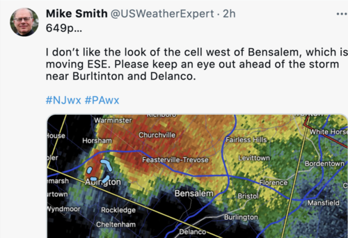
Attached is my tweet from 6:49pm Thursday evening -- the time I said I would have warned. I don't issue my own "tornado warnings" because I do not wish to confuse people with the official warnings from the NWS. I was extremely concerned about that storm and couldn't believe the NWS didn't issue a tornado warning until 7:07pm.

Part of the basis for my concern at 6:49 was the 6:47pm hook echo (second image). While I agree the velocity data quality left something to be desired, the hook plus the report of a funnel cloud in the area was plenty for me given the atmospheric environment.

I don't agree with all of the research. For example, I've had very good luck with "tail-end Charlies" over the years.

Bottom line: If you feel this was an adequate performance from the PHI NWS, with the warning having a lead time of minus three minutes, that's fine. Everyone looks at things differently. However, I emphatically disagree.Bensalem, My tweet, 649 .pngBensalem Tornado, hook echo, 647p.pngI


Also "a warning was obviously needed became even evident in the next few minutes" - hindsight is 20/20. This is a terrible bias we has humans have when reviewing past events.
 
FYI, I have been issuing tornado warnings since 1971. I have published papers on this topic and am aware of the tornado research you cited. I do not care comment on every point your raised except the one pertaining to "hindsight."
An interesting approach after I said "experience does not equal expertise". There's a correlation, but it is far from perfect and usually does not need to be self-proclaimed. If you spoke as if you were up to date with how things are done and the research involved, I would not have felt compelled to comment in the first place.


Bottom line: If you feel this was an adequate performance from the PHI NWS, with the warning having a lead time of minus three minutes, that's fine. Everyone looks at things differently. However, I emphatically disagree.
I did not come here to judge PHI's warning performance, nor did I say I do or do not agree with what they did. I came here to correct/clarify some points with definitive facts so that folks reading this thread can have a proper view of the situation.


Attached is my tweet from 6:49pm Thursday evening -- the time I said I would have warned. I don't issue my own "tornado warnings" because I do not wish to confuse people with the official warnings from the NWS. I was extremely concerned about that storm and couldn't believe the NWS didn't issue a tornado warning until 7:07pm.

Part of the basis for my concern at 6:49 was the 6:47pm hook echo (second image). While I agree the velocity data quality left something to be desired, the hook plus the report of a funnel cloud in the area was plenty for me given the atmospheric environment.
I'm also not saying you were incorrect. If you would have issued a tornado warning at that time as you said, you would have clearly been correct. My point was if you base tornado warnings solely on a supercell's reflectivity, broad rotation, and the environment it is in, your POD will be superb, but your FAR will be abysmal. Those are definitely nudgers, but far from telling the entire picture. If that's all it took, training to issue warnings would not take as long as it does.


I don't agree with all of the research. For example, I've had very good luck with "tail-end Charlies" over the years.
I can't say what you experience was/is wrong. However, your experiences (or anyone's for that matter) are not an objective measure of reality. If you disagree with the research, produce your own objective, peer-reviewed counter argument.
 
Alex,

Again, thank you for commenting. I have reproduced some snippets of your just-published comment below and wish to comment on them as a whole.

If your approach is superior to the techniques I have developed and my experience, why have the NWS's own tornado warning statistics cratered the last ten years?

The 2012-2020 numbers are approximately equal to the numbers in the mid-90's. In most of science the goal is to get better with time. Instead, the NWS has regressed by about twenty years (note: NWS hurricane warnings have improved during this period). The figure below is from my May 21 piece on this topic in the Washington Post, https://www.washingtonpost.com/weather/2021/05/21/joplin-tornado-warning-improvement-nws/ .
Screen Shot 2021-08-04 at 1.19.32 PM.png

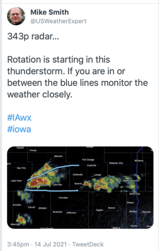
If the many examples I have produced are not sufficient, here is another example of a completely unwarned Lake City EF-3 -- no severe thunderstorm or tornado warning. This was the first tornado of the day at the beginning of the underforecasted regional outbreak in Iowa on July 14. Below is my tweet trying to let people in the path of the supercell they were in danger.
Lake City Iowa tornado tweet, July 14, 2021.png
I provided by Twitter followers with +4 minutes of lead time. The NWS lead time was -5 minutes as the tornado moved into Lake City.

While I think I understand what you are saying, I wish to confirm: When you wrote, "IF you would have issued a tornado warning at that time..." You aren't suggesting that I issue my own tornado warnings, are you? When the NWS is clearly missing a major, and obvious, tornado situation, I feel an obligation to let my followers know but I would be extremely hesitant to call them "tornado warnings" as I do not wish to cause confusion with the NWS. Do you disagree?

As to, "folks reading this thread can have a proper view of the situation," I would say this: The National Weather Service's tornado warning program has serious issues at this time. The reasons are not clear to me. That is why we desperately need a National Disaster Review Board -- modeled on the highly successful NTSB -- to, 1) review the performance of all parties when a major disaster occurs and to make recommendations for improvement, and to 2) take over warning verification from the NWS. Perhaps tornado warnings are simpler than the NWS is making them these days.

Again, thank you for the respectful dialog.

Best wishes,

Mike Smith

An interesting approach after I said "experience does not equal expertise".

folks reading this thread can have a proper view of the situation.

If you would have issued a tornado warning at that time as you said, you would have clearly been correct.

I can't say what you experience was/is wrong. However, your experiences (or anyone's for that matter) are not an objective measure of reality. If you disagree with the research, produce your own objective, peer-reviewed counter argument.
 
Great analysis written up on PhillyWX.com

 
That's a good write-up and thread about the Greater Philadelphia area tornadoes (and farther into New Jersey). Lots of gradients of parameters over the area (both directions depending on parameter). Severe wx loves gradients!

As for warnings overall, I believe a couple shifts impact the POD. Recently the NWS seeks to reduce FAR. I don't agree with the goal if POD falls. We talk about warning fatigue, but getting hit without warning is worse. Public understands tornado warnings do not necessary mean, it's going to hit my house. Public takes shelter because it's developing and/or nearby.

Few years ago there was also talk about the less classic storm mode (on average) since the crazy 2011 year. We have more QLCS tornadoes and more non-supercell tornadoes. Classic outbreaks can be tragic, but textbook storms pad warning verification.

My own observation across industries is an over-reliance on quantitative analysis and software. Experience and pattern recognition absolutely matter! It's a law of science in business, quality goes up with experience. I have seen business demand forecasts degrade as experience retires. Layers of quant adjustments deliver a product that does not even match possible reality. No qualitative QC.

I'm not in the NWS so I cannot say that's what's happening. However Mike raises valid questions, his hypotheses regarding the issues are reasonable, and we should investigate the trends. Don't sacrifice POD for FAR.

Back to the Philly suburbs: Cell Mike referenced had modest rotation, but far from the radar site. With the hook echo, and funnel report, one could reasonably conclude better rotation at lower elevations. I would have advised a B2B client tornado at the same time. Plus if you believe in WOF, the parameters!
 
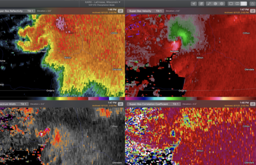
I am sorry to report that there was another obvious tornado warning that was missed by the National Weather Service this afternoon. It was in southwest Wisconsin. Three meteorologists were tweeting about the tornado threat well before the warning.

The there was considerable lofted-debris on CC for two minutes before the tornado warning was issued. Attached is my 4-panel display two minutes before the tornado warning was issued.

Tomer Burg - Homepage yielded a peak estimated intensity of EF-2 (significant).

If you would like to see the sequence of tweets: MSE Creative Consulting Blog: Another Too-Late #Tornado Warning http://mikesmithenterprisesblog.com/2021/08/another-too-late-tornado-warning.html?spref=tw…

The United States, for this and many good reasons, desperately needs a National Disaster Review Board.
Screen Shot 2021-08-11 at 7.59.33 PM.png
 
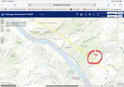
As I posted earlier, I was away during this oh-so-close-to-home event. I got back last Friday and had occasion on Monday evening to check out some of the damage at Washington Crossing park, which was hit by the New Hope PA to Ewing NJ tornado. I was roughly inside the area marked in the red circle below, which includes the main entrance into the park from Washington Crossing-Pennington Road. There were numerous large trees uprooted, and it was amazing to see the grass flattened in spots. I was trying to relate what I saw to the tornado’s plotted path and rotation, and it was not making sense to me.

I know the path as shown does not represent path width. But I assume it represents the center of the path. What didn’t make sense to me is that on the northern side of the plotted path, just north of the entrance road that you can faintly see on the map, I saw numerous uprooted trees pointing SE, indicating a NW wind (see crudely-drawn arrow). One would expect wind in the *opposite* direction in that location, unless the tornado was anti-cyclonic (if it was, that would have been unusual enough to have been mentioned somewhere, but I have seen nothing like that...) More confusing, I saw one tree that looked like it had been blown in the opposite direction (toward the NW) in the midst of all of that. And just one other blown over toward the NW just to the south of the entrance road, but then another blown toward the SE a little farther to the south of the entrance road. If I ignore the plotted path, I would expect trees blown to the SE to be in a southern quadrant of the tornado, and to the NW in a northern quadrant. If I had continued to walk further away from the entrance road to the NE, would I have seen trees blown in the opposite direction of the others, to the NW? Maybe, but that wouldn’t make sense relative to how the path was plotted, and anyway it seemed like the damage had stopped where I stopped walking. It was perplexing, and really bothered me that I couldn’t make sense out of it, but admittedly I am not a damage surveyor...😏

I attempted to go back for another look the following evening on my way home from work. The skies were darkening with storms developing, but I had no clear view of the sky on my drive. I arrived at the park, pulled into the lot, and checked radar before venturing out. It turns out a severe storm was bearing down on me, just four miles away. Is there no end to the cruel irony of weather, thwarting my attempts to survey the damage from a tornado right near my home that I missed because I was away?!? 😒

Anyway, if anybody has any insight that can help me make sense of my observations I would appreciate it!


DA92D2B7-2F04-4370-8969-7C61A6FB1D29.jpeg
 
Back
Top