Tornadoes Hit Philadelphia & New Jersey 7/29/21

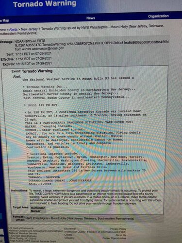
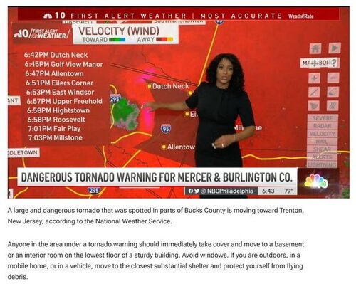
I live in Newtown PA and there were two bonafide tornadic supercells that tracked relatively close to home, one through New Hope / Washington Crossing just 5-7 miles north, and another in Bensalem less than 10 miles to the south. Meanwhile, I just about missed the entire thing because my family and I are vacationing down in Long Beach Island (LBI) NJ. You can’t imagine how pissed off I was about the irony of missing a once-in-a-lifetime local weather event! Was distracted through an entire family dinner. Typical chaser luck. I can’t remember ever seeing radar signatures like this in the area, or seeing PDS wording and “confirmed large and dangerous tornado” around here (although, even with that wording, it said “radar confirmed,” don’t remember ever seeing anything like that, isn’t it usually radar *indicated*, or confirmed only through actual sighting??)

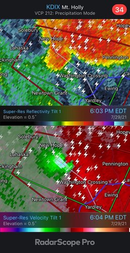
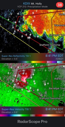
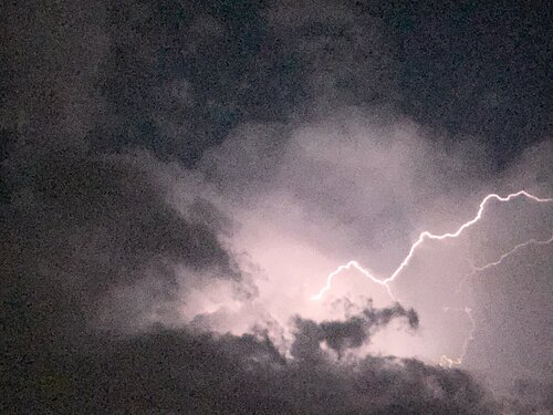
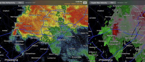
The more southern supercell did finally arrive at the NJ coast and passed through LBI near Barnegat to my north. It was dark by then so I didn’t attempt to chase it, but enjoyed watching the lightning as the storm came across the bay, then walked to the beach to watch it out over the ocean. Enjoyed being able to get the family into it as well, in fact my wife got the lightning shot below. I am also posting a radar image from the northern storm’s close passage to my hometown (I live immediately south of where it says “Newtown Grant”) and the southern storm as it approached LBI.

There was significant damage in Bensalem, speculation that it could have been EF-3, which may tie or exceed the record for Bucks County PA. Looking forward to seeing the surveys.

Interesting that there was morning precip and little sunshine in the area during the day. Many folks on the Philly weather forum commenting, imagine if there had been sun... and another noting this should be “put in the memory banks - its all about #Dynamics”

@Saul Trabal thanks for starting this thread, don’t recall seeing you post before and always glad to meet another local chaser!
 

Attachments

  • E1FE51B5-D021-42F7-8809-5D0622580D6A.jpeg
    E1FE51B5-D021-42F7-8809-5D0622580D6A.jpeg
    172.8 KB · Views: 0
  • 316DFBBA-CD04-4064-89B4-9291A9B58C4D.jpeg
    316DFBBA-CD04-4064-89B4-9291A9B58C4D.jpeg
    163 KB · Views: 0
  • 17F90614-B94A-4C6C-BD47-9B527331D30F.jpeg
    17F90614-B94A-4C6C-BD47-9B527331D30F.jpeg
    390.1 KB · Views: 0
During the past ten years, essentially since Joplin, National Weather Service tornado warnings have become less accurate. That resulted in little warning for the Bensalem Tornado yesterday evening. Bensalem Tornado: Another Dangerous National Weather Service Warning Miss

I don't know why the lead time has been cut nearly in half nor why the PoD has dropped by 18%. But, this trend is extremely dangerous and a solution needs to be found as quickly as possible. My recommendation is that Congress creates a National Disaster Review Board modeled after the National Transportation Safety Board. The latter has been hugely successful at making aviation and other forms of transportation safer.
 
I can’t remember ever seeing radar signatures like this in the area, or seeing PDS wording and “confirmed large and dangerous tornado” around here (although, even with that wording, it said “radar confirmed,” don’t remember ever seeing anything like that, isn’t it usually radar *indicated*, or confirmed only through actual sighting??)

I can't confirm because I wasn't watching radar yesterday but I am willing to bet a large TDS showed up via correlation coefficient which allowed the NWS to confirm a "large and dangerous tornado" without chaser/spotter reports confirming it visually.
 
During the past ten years, essentially since Joplin, National Weather Service tornado warnings have become less accurate. That resulted in little warning for the Bensalem Tornado yesterday evening. Bensalem Tornado: Another Dangerous National Weather Service Warning Miss

I don't know why the lead time has been cut nearly in half nor why the PoD has dropped by 18%. But, this trend is extremely dangerous and a solution needs to be found as quickly as possible. My recommendation is that Congress creates a National Disaster Review Board modeled after the National Transportation Safety Board. The latter has been hugely successful at making aviation and other forms of transportation safer.

Mike, I read your blog post. I can’t explain the delay from 7:03 to 7:07, except to assume that the velocity simply didn’t trip the necessary algorithmic criteria to issue a warning? As for the 6:49 image, you only showed the reflectivity, not the velocity, so it may be unfair to suggest they should have issued a warning that soon, based solely on a reflectivity appendage which is fairly common with non-tornadic storms.

I know you listed some possible theories for the reasons behind the alleged delays, but I always thought there was an algorithm that determines when the velocity couplet exceeds a threshold, so I’m not sure how there could be a deterioration in warning lead time, wouldn't this imply that someone was literally ignoring an alarm?? My understanding is that human intervention can issue a warning earlier than the threshold is exceeded, but not later ... But admittedly I don’t know too much about it, this is just my amateurish anecdotal understanding...

EDIT: I went back and watched the video in the Tweet you linked, where you say the tornado is visible and then the warning is issued after. I couldn’t actually see the tornado, couldn’t that have just been hard-wrapping RFD, forming the couplet that prompted the warning?
 
Hi James,

Happy to elaborate.

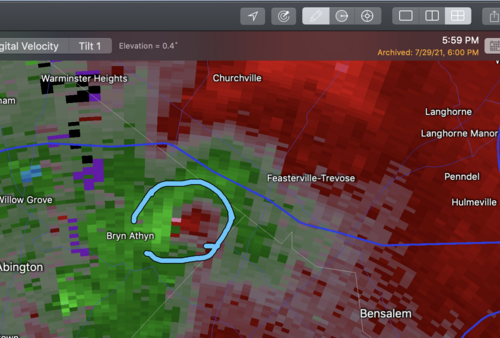
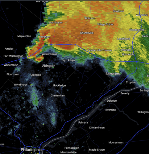
I have attached the 6:49p velocity and reflectivity for reference. In the preceding two minutes, the inbounds greatly increased. So, we had a supercell's pendant echo that was starting to grow a hook between Horsham and Abington and a rapidly increasing couplet (likely from an increasing RFD). Given it was the "tail-end Charlie" with a SIGTOR of 2 and the northern supercell was producing tornadoes, it was a pretty easy warning. That a warning was obviously needed became even evident in the next few minutes as the Bensalem supercell was clearly a right mover.

Had I been working the WeatherData/AccuWeather warning desk and had I had a client in Bensalem, I would have tornado warned at 6:49. However, I don't necessarily fault the NWS for not warning at 6:49. Reasonable people can disagree there. But, by 6:55-7p, it was absolutely unmistakable. Addition at 2:40pm. Mt Holly NWS has rated the storm EF-3.

Some NWS offices rely more heavily on various techniques and algorithms while others don't pay much attention to them. I don't know the specifics of how Mt Holly does it.

If this were an isolated incident, I would not have written today's blog post about Bensalem nor my May 21 piece for the Washington Post (while there is a link in my blog post, for convenience here is my WaPo article: https://www.washingtonpost.com/weather/2021/05/21/joplin-tornado-warning-improvement-nws/ ).

Unfortunately, there have been multiple obvious, unwarned tornadoes between May 21 and yesterday. For example, here is one from northern Indiana: Friday: Another Dangerous Missed Tornado Warning This was rated by the NWS was "upper EF-2."

Right now, very straightforward tornadoes up to perhaps F-3 intensity, are improperly warned. If this continues, people are going to lose their lives.

That is why I urge Congress to quickly create a National Disaster Review Board modeled on the hugely successful NTSB.

Thank you for asking.

Mike

Screen Shot 2021-07-30 at 1.31.26 PM.png

P.S. I forgot to include the PHL TDWR data. This is from 6:59pm.
Screen Shot 2021-07-30 at 1.57.06 PM.png


Mike, I read your blog post. I can’t explain the delay from 7:03 to 7:07, except to assume that the velocity simply didn’t trip the necessary algorithmic criteria to issue a warning? As for the 6:49 image, you only showed the reflectivity, not the velocity, so it may be unfair to suggest they should have issued a warning that soon, based solely on a reflectivity appendage which is fairly common with non-tornadic storms.

I know you listed some possible theories for the reasons behind the alleged delays, but I always thought there was an algorithm that determines when the velocity couplet exceeds a threshold, so I’m not sure how there could be a deterioration in warning lead time, wouldn't this imply that someone was literally ignoring an alarm?? My understanding is that human intervention can issue a warning earlier than the threshold is exceeded, but not later ... But admittedly I don’t know too much about it, this is just my amateurish anecdotal understanding...

EDIT: I went back and watched the video in the Tweet you linked, where you say the tornado is visible and then the warning is issued after. I couldn’t actually see the tornado, couldn’t that have just been hard-wrapping RFD, forming the couplet that prompted the warning?
 
Last edited:
During the past ten years, essentially since Joplin, National Weather Service tornado warnings have become less accurate. That resulted in little warning for the Bensalem Tornado yesterday evening. Bensalem Tornado: Another Dangerous National Weather Service Warning Miss

I don't know why the lead time has been cut nearly in half nor why the PoD has dropped by 18%. But, this trend is extremely dangerous and a solution needs to be found as quickly as possible. My recommendation is that Congress creates a National Disaster Review Board modeled after the National Transportation Safety Board. The latter has been hugely successful at making aviation and other forms of transportation safer.

I wonder if part of the problem, in this area at least (I live in northeastern New Jersey) is that tornadoes are fairly rare around here. Yesterday was practically unprecedented. I recall one TV report that said there were 14 tornado-warned storms (radar indicated?) and two confirmed tornadoes. People around here seem pretty blasé about tornadoes because they are so infrequent. It also seems fairly rare that we get anything above an EF1 or EF2 in the Tri-State area-and I should probably include Pennsylvania in that.
 
Saul,

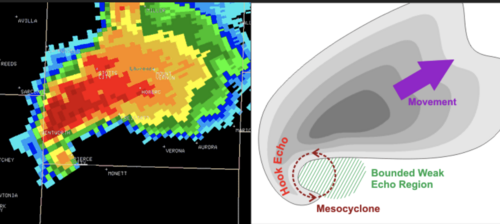
I don't know but it is hard for me to imagine that is the reason. I have attached an actual textbook illustration of a toranadic supercell and it was more or less identical to yesterday evening's PA-NJ tornadoes. It is difficult for me to understand why this wouldn't have been immediately recognized for the threat it was, especially since SPC had issued a tornado watch and there was a SIGTOR of 2.

There was an F-5 tornado in Pennsylvania in 1985 and several F-4's. It is necessary for meteorologists of the region to be well-versed in warning techniques.

Mike
Screen Shot 2021-07-30 at 3.04.19 PM.png

I wonder if part of the problem, in this area at least (I live in northeastern New Jersey) is that tornadoes are fairly rare around here. Yesterday was practically unprecedented. I recall one TV report that said there were 14 tornado-warned storms (radar indicated?) and two confirmed tornadoes. People around here seem pretty blasé about tornadoes because they are so infrequent. It also seems fairly rare that we get anything above an EF1 or EF2 in the Tri-State area.
 
One thing I wonder is whether this trend is related to some effort to reduce the false alarm rate. Certainly seems to me like these storms should have been tornado warned, as you say. I think that reducing the false alarm rate is a worthy goal, but it should not come at the expense of delayed warnings for storms that do produce tornadoes, especially strong ones as in these examples. One could, I suppose, argue that there is an inherent tradeoff, but from the images posted by Mike above, the PA storm seems pretty obvious with regard to tornado potential.
 
Hi John,

Thank you for your comments.

Harold Brooks and Victor Gensini (B&G) say exactly that: the big drop in PoD is related to an attempt to cut false alarms. Please see: https://www.washingtonpost.com/weather/2021/06/11/improving-tornado-warnings-preparation-nws/

Their hypothesis is that it is worthwhile to have "one unwarned F-3 tornado every three years" in order to decrease the NWS' tornado FAR from 74.2 to 70.4 percent. I rather strongly disagree. My full reply is here: Friday: Another Dangerous Missed Tornado Warning

The problem is not confined to the reduced PoD. Lead-time has regressed to 1994 levels. The lead time on the Bensalem Tornado was minus three minutes. That tornado would have been an easy warning, with about ten minutes of lead time, in, say, 2008.

As I note in my reply to B&G, if they are correct, one person will die each year in order to achieve the imperceptibly small (to the public) decrease in FAR. This seems like a terrible trade to me. But, it is actually worse. I'm not particularly concerned about EF-0 tornadoes. But, the NWS is missing EF-2's and EF-3's (like Thursday's Bensalem EF-3) at a far greater rate than Brooks and Gensini predict. That means, inevitably, more will be killed. Given what occurred in Joplin, another catastrophic fatality tornado is in the realm of possibility. This is why I am hitting this topic so hard.

With the much higher rate of missed significant tornadoes (≥EF-2) than predicted by Brooks and Gensini, it is safe to say the misses are not due to the attempt to decrease false alarms. Something else is at work, but I don't know what it is. I can speculate that some of the factors might be:
  • The retirement of my generation of meteorologists and our expertise. This is especially true since we learned to warn tornadoes based on hooks, right-movers and other non-Doppler wind techniques. Given the funnel cloud report at 6:49pm along with the hook (see image) west of Bensalem at 6:47, it would have been an easy warning even without Doppler.
  • The hiring of meteorologists fresh out of college. I am aware of multiple instances in three months where the NWS hired meteorologists who graduated in May, even when a more experienced candidate had applied.
  • Degradated radar training in the NWS. A person currently in the NWS, when discussing the tornado warning problem said to me, "Twenty years ago, radar training was a month in Kansas City. A decade ago, it was a week in Kansas City. Now, it is a couple of hours from the SOO." I don't know whether this is true everywhere or in all cases. But, if it is largely true, it is a serious issue.
  • Lack of attention. A quarter-century ago, the NWS worried about the weather wire and NOAA Weather Radio. Now, there is a tremendous amount of social media that has to be accomplished. Is this drawing attention away from mesoscale analysis and monitoring?
Note: I do not know to the extent any of the above are true. I have heard from people who believe there is no problem at all.

This is why we need a National Disaster Review Board. I explain in detail, here: Editorial: Renewing My Call For a National Disaster Review Board

The Board would have two responsibilities:
  • Like the NTSB, National Chemical Incident Board, and the others, it will comprehensively investigate major disasters to learn what went wrong and what went well. It would not be limited to reviewing the NWS. It would review the NWS, FEMA, Red Cross and other agencies, public and private, just like the other federal boards do. It is a terrible policy for the NWS to investigate itself.
  • It will remove warning verification from the NWS. Lots of people, under the promise of confidentiality, send me things. Correctly or not, there are widespread allegations the NWS "fudges" times and other information when they did not have a warning out. On one occasion, a NWS office in Kansas elected not to add a tornado report of mine (even though it was documented with photos) to their database in a situation where they did not have a tornado warning. That gives me a sense those allegations have credibility.

The huge death toll in Joplin -- by far, the worst in the history in the tornado warning era -- was due to mistakes made by the NWS and local emergency management. See: Amazon.com: "When the Sirens Were Silent" How the Warning System Failed a Community eBook: Smith, Mike: Kindle Store

The NWS's JLN "Service Assessment" was, at best, very poor. Others have called it a "cover-up." But, most meteorologists in and out of the NWS don't know that. As a result, a number of sub-optimal decisions have stemmed from the information in the JLN report.

Before another Joplin, Sandy, or a June 2016 Greenbrier Flash Flood (23 dead) can occur, we must fix this.

I am a Reagan Conservative and I believe we would be better off if the federal government was smaller. That stipulated, we must expand the government to create the National Disaster Review Board.

John's comments were appreciated and I would be happy to read any comments or answer any questions you might have. Please, fire away. Thanks, everyone, for reading.

Mike

Screen Shot 2021-07-31 at 5.21.17 PM.png


One thing I wonder is whether this trend is related to some effort to reduce the false alarm rate. Certainly seems to me like these storms should have been tornado warned, as you say. I think that reducing the false alarm rate is a worthy goal, but it should not come at the expense of delayed warnings for storms that do produce tornadoes, especially strong ones as in these examples. One could, I suppose, argue that there is an inherent tradeoff, but from the images posted by Mike above, the PA storm seems pretty obvious with regard to tornado potential.
 
Last edited:
Thank you, James.

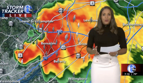
The Bensalem Tornado touched down at 7:04 and reached the town at 7:11. It lifted one minute later. That made the 'lead time' a minus three minutes. Bensalem, ABC6, 710p.png
Above is a screen shot from ABC6, the most-watched news operation in Philadelphia. At that moment, she is speaking the words that a tornado warning had been issued for Bucks Co., north Philly and Bensalem. Note the time (lower right). Even though the warning was officially issued at 7:07, it takes some time to get this on the air as there were multiple other tornado warnings they were covering. Essentially the tornado was in Bensalem as the warning was going out. The tornado would lift just two minutes later. It is fortunate no one was killed.


Mike, I posted a link to your blog post to the Philadelphia weather forum (PhillyWx.com) thread for the 7/29/21 event to spark some discussion. Here is an interesting post from someone who agrees with you that the Bensalem warning was late:

 
Back
Top