It’s obvious everyone is starting to get restless for the 2020 season, so here’s a thread just for it!
-
While Stormtrack has discontinued its hosting of SpotterNetwork support on the forums, keep in mind that support for SpotterNetwork issues is available by emailing [email protected].
You are using an out of date browser. It may not display this or other websites correctly.
You should upgrade or use an alternative browser.
You should upgrade or use an alternative browser.
State of the chase season 2020
- Thread starter Todd Lemery
- Start date
- Status
- Not open for further replies.
Shawn Gossman
Supporter
The weekend of January 10-12 was my missed opportunity for starting this chase season. I stayed in a cabin with my girlfriend and about 6 miles away, an tornado touched down. It was later determined as an EF-1. We slept right through it, LOL. In fact, when I woke up later that night, the storms had passed but I realized the power was out. Outside looked like some wind occurred haha but no major damage at least in our particular area.
I do try to avoid night time chasing, though. So many potential problems that could occur. Night time chasing and really fast storms.
I do try to avoid night time chasing, though. So many potential problems that could occur. Night time chasing and really fast storms.
A quick look at the GFS is currently showing early next week dews in the low 60’s in East Texas out ahead of a low. The shear profiles are looking favorable and if it comes together it might offer another early season taste of chasing. East Texas isn’t exactly great chasing terrain though.....
Devin Pitts
EF2
Hard to really make any calls this early right now, but I cant help but think our background state currently is about the best one could hope for. Lack of drought and high soil moisture content in the traditional plains chase states is always a good thing!
Last edited:
Warren Faidley
Supporter
CFS is suggesting something during the first week or so of March. Long way out, but it's fun to watch the ultra range models and test their accuracy.
Randy Jennings
Supporter
- Joined
- May 18, 2013
- Messages
- 866
Interesting tweet from Victor Gensini today saying this season could be interesting.
Andy Wehrle
EF5
GFS is hinting at an extended period of a broad belt of vigorous 500mb SW flow east of the Rockies starting in about 5-7 days and continuing through the end of this morning's 12Z run. The kind of pattern that would be awesome in May (or at least have the potential to be awesome, last year was the ultimate example of "the devil's in the details" when it comes to severe local storms forecasting) but even so may yield some early season severe weather, most likely in the Dixie jungles.
Alex Elmore
EF2
GFS is hinting at an extended period of a broad belt of vigorous 500mb SW flow east of the Rockies starting in about 5-7 days and continuing through the end of this morning's 12Z run. The kind of pattern that would be awesome in May (or at least have the potential to be awesome, last year was the ultimate example of "the devil's in the details" when it comes to severe local storms forecasting) but even so may yield some early season severe weather, most likely in the Dixie jungles.
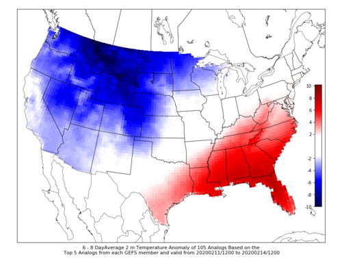
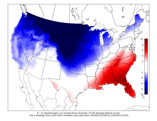
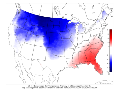
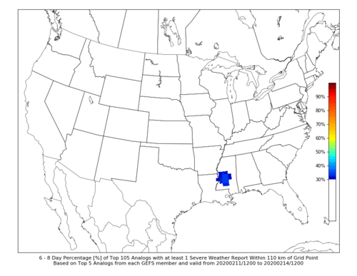
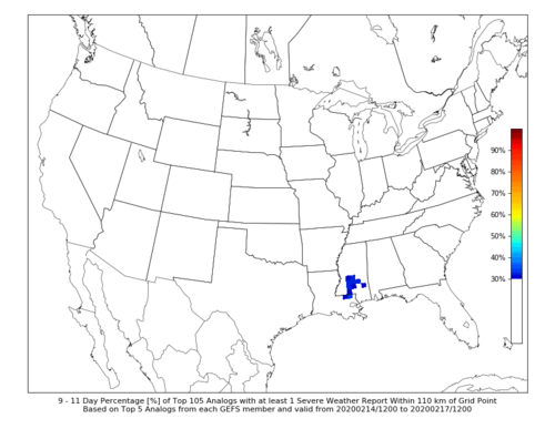
Building on this, CIPS Extended Analog Threat Guidance is signalling troughing in western/central US for the next 1-2 weeks, keeping at least Dixie in the warm sector (surface temp anomaly maps below). There's even some severe weather occurring in some of the analogs in the 6-8 and 9-11 day period (percent of 1 severe report maps also below). While this may seem low, any signal for severe weather at this range this time of year is rare in the guidance, so it's worth keeping an eye on.
Attachments
Dan Robinson
EF5
March 1 is finally in sight on some of the long-range products. Unfortunately nothing of interest showing yet for the Plains/Midwest. The southern stream is shown hugging the coast through the end of the month. GFS puts a big wave through Dixie next weekend, but with no instability.
Alex Elmore
EF2
Several CIPS products are signalling a pattern favorable for storms across the Southeast in the current Day 6-8 time frame. Deterministic and ensemble model output shows a system traversing that area around that time as well. May warrant watching if you happen to live in the Southeast and/or enjoy fast storm motions in densely wooded areas.
Dan Robinson
EF5
Monday-Wednesday does look good for at least some lightning as far north as I-70 across the Plains and Midwest. Not much to speak of afterward.
Greg McLaughlin
EF5
It appears we are in for an active March. Several opportunities appear to be lining up in the weeks ahead. A very active jet stream with troughing over the west and ridging over the east is forecast to become established as we head deeper into March. The GoM SSTs have been very warm this winter with minimal arctic intrusions. Moisture recovery time over the Gulf basin appears to be fairly quick ~1 or 2 days. It's only a matter of time before we see things line up over the plains. The overall consensus among meteorologists I have been talking with/following believe we are going to see an active spring tornado season. Curious to see the ERTAF forecast. My guess is they will be forecasting average to above average tornado probabilities for the second half of March.
Andy Wehrle
EF5
Active Marches can be a mixed bag for the rest of the spring. Several people have posted on here in the past that, anecdotally, they've observed that active Marches tend to be worse for chasers as the spring's window for a western troughing pattern is "wasted" on suboptimal early season setups and/or the best action occurs in Dixie Alley.
However, we all know the atmosphere doesn't really work that way. Also anecdotally, I saw my only tornado of 2016 on March 15th near the I-80 corridor in IL, and that May still had Wynnewood and DDC-Chapman in store.
However, we all know the atmosphere doesn't really work that way. Also anecdotally, I saw my only tornado of 2016 on March 15th near the I-80 corridor in IL, and that May still had Wynnewood and DDC-Chapman in store.
Jeff House
Supporter
Already seeing signs of Great Lakes ridging in the weekly forecasts. That's bearish early season. Just as well. Dixie needs a break already!
Moving later into April and for May, the long-term pattern is indeed trough West. PV has been locked up tight. It weakens with the season, but we should avoid any silly strato warmings. That's generally bullish else equal.
Still much to settle in the tropical oceans. IOD is calming down. Nino is too. Will Nina get a foothold? Regardless, long-waves have been trough West often. Even if not constant, I lean toward a fruitful chase season in the Plains later.
For those mentioning ERTAF, 2020 forecasts have commenced: https://atlas.niu.edu/ertaf/
- Status
- Not open for further replies.
Similar threads
- Replies
- 0
- Views
- 902
- Replies
- 20
- Views
- 4K
- Replies
- 18
- Views
- 3K
- Replies
- 59
- Views
- 9K
- Replies
- 47
- Views
- 4K

