• While Stormtrack has discontinued its hosting of SpotterNetwork support on the forums, keep in mind that support for SpotterNetwork issues is available by emailing [email protected].

Southwestern US Monsoon 2025

...but it is just early July...
...chasing in that region...
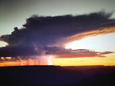
I lived in AZ for eight years, and the monsoons provided the singular opportunity for storms w/ lightning with often good clarity. While Warren shot in the Tucson area, I focused on Grand Canyon & Flagstaff in the north.

The freezing level as it relates to lightning production’s seemingly lower compared to where the photographer stands when you’re already at 6000-7000 feet, so lightning appears to happen quickly from smaller-looking storms.

I believe there’s time for rebounds and reboots for a couple of months still.

One of my favorite things, the anvils from the North Rim of the Grand Canyon would blow off a dozen miles to the South Rim and create a steely gray-blue look to the sky. I also particularly remember the flash floods at the Park would spill out over the sides of the Canyon rim.

When the storms evaporated, they left behind orphan anvils: Cirrus spissatus cumulonimbogenitus. I learned that Latin phrase just because it sounds so dorky. 🤣 But, it's not entirely necessary to do the Southwest if you already know where and when to get other lightning storms.
 
Last edited:
William Monfredo said:
I also particularly remember the flash floods at the Park would spill out over the sides of the Canyon rim.
Oooh I bet that would be a sight to see! (and deff would need videoing !)


Cirrus spissatus cumulonimbogenitus.
sounds like some sorta disease (especially the last word) or something .lol.
I'm gonna have to put that into an AI image generator & see what it comes up with.....
 
Well, well, well..... was going to write something about how next week was looking, but the NWS did a much more professional job, so I'll post their comments:

NEXT WEEK IS SHAPING UP TO BE AN ACTIVE MONSOON WEEK RIGHT AS WE GET
INTO THE HEART OF THE MONSOON FROM A CLIMATOLOGICAL PERSPECTIVE. THE
MID-UPPER LEVEL HIGH WILL GRADUALLY SHIFT TOWARDS THE FOUR CORNERS
WITH NE FLOW OVER SE ARIZONA EARLY IN THE WEEK, WHICH WILL THEN
TRANSITION TO EAST TO SOUTHEAST FLOW WITH THE HIGH TO OUR NORTHEAST
AND A MID LEVEL DISTURBANCE TO OUR SOUTH AND WEST HELPING TO PUMP IN
ADDITIONAL MOISTURE WITH ELEVATED STORM CHANCES. THIS TYPE OF SETUP
WOULD YIELD STORM IMPACTS LEANING TOWARDS A SEVERE THREAT AT THE
BEGINNING OF THE WEEK WITH A TRANSITION TO BOTH A SEVERE AND FLASH
FLOOD THREAT AS THE WEEK PROGRESSES.
 
Back
Top